


Summary
The Swabian-Franconian Forest (German: Schwäbisch-Fränkischen Waldberge, also Schwäbisch-Fränkischer Wald) is a mainly forested, deeply incised upland region, 1,187 km² in area and up to 586.4 m above sea level (NHN),[1] in the northeast of Baden-Württemberg. It forms natural region major unit number 108 within the Swabian Keuper-Lias Land (major unit group 10 or D58). Its name is derived from the fact that, in medieval times, the border between the duchies of Franconia and Swabia ran through this forested region. In addition, the Swabian dialect in the south transitions to the East Franconian dialect in the north here.
| Swabian-Franconian Forest | |
|---|---|
 Finsterroter lake in Naturpark Schwäbisch-Fränkischer Wald | |
| Highest point | |
| Peak | Hohe Brach |
| Elevation | 586.4 m above NHN |
| Dimensions | |
| Area | 1,187 km2 (458 sq mi) |
| Geography | |
 The natural region major unit of the Swabian-Franconian Forest
| |
| State | Baden-Württemberg, Germany |
| Range coordinates | 49°02′13″N 9°33′01″E / 49.0369278°N 9.5503778°E |
| Parent range | Swabian Keuper-Lias Land |
Hill ranges and hills edit
The Swabian-Franconian Forest is divided clockwise (beginning roughly in the north) into the Waldenburg Hills, Mainhardt Forest, Limpurg and Ellwangen Hills, Virngrund, Murrhardt Forest, Löwenstein Hills, Heilbronn Hills and Sulm Plateau; in addition the valley of Weinsberger Tal, which lies between the last two uplands, is part of the region
The highest point of the Swabian-Franconian Forest is the Hohe Brach (586.4 m). Other high hills include the Hagberg (585.2 m), Hornberg (580.0 m), Hohenstein (572 m), Hohenberg (568.9 m), Hohentannen (565.4 m), Altenberg (564.7 m), Stocksberg (538.9 m), Flinsberg (534.8 m), Juxkopf (533.1 m) and Steinknickle (524.9 m).
Protections edit
Naturpark Schwäbisch-Fränkischer Wald, or Swabian-Franconian Forest Nature Park in English, is a nature park and protected area within the Swabian-Franconian Forest. The nature park covers an area of 1,270 km², including most of the Swabian-Franconian Forest, but also large areas of adjacent cultural landscapes and historical monuments.[2]
Gallery edit
-
 Rural cultural landscape
 -
 Meinhardt Forest
 -

-
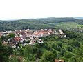 Towns and agriculture (Löwenstein)
 -
 Large parts of the original forest has been swapped for agriculture


- Naturpark Schwäbisch-Fränkischer Wald
-
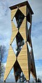 Altenbergturm, a lookout tower
 -
 Forest stream
 -

-
 Autumn scene
 -
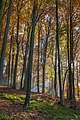 Autumn in the nature park


Literature edit
- Paul Strähle (2006), Naturpark Schwäbisch-Fränkischer Wald : revised by Theo Müller (in German) (4th, revised and expanded ed.), Stuttgart: Theiss, ISBN 3-8062-2033-6
- LUBW Landesanstalt für Umwelt, Messungen und Naturschutz Baden-Württemberg (publ.): Naturführer Schwäbischer Wald. (Reihe Naturschutz-Spectrum. Gebiete, Vol. 29). verlag regionalkultur, Ubstadt-Weiher, 2007, ISBN 978-3-89735-507-1.
References edit
- ^ Map services of the Federal Agency for Nature Conservation
- ^ "Naturpark Schwäbisch-Fränkischer Wald" [Swabian-Franconian Forest Nature Park] (in German). Retrieved 11 September 2019.
External links edit
- Natural region fact file Schwäbisch-Fränkische Waldberge (108) (N.B. the small Baden-Württemberg element of the Central Franconian Basin (113) and the Frankenhöhe (114) is integrated here.) – LUBW (pdf, 12.5 MB)
- Landscape fact file for the Swabian-Franconian Forest by the Bundesamt für Naturschutz, at bfn.de
- Detailed LUBW natural regional map at Basis by google.maps (Open "Natur und Landschaft")
- Swabian-Franconian Forest Nature Park (official homepage)