TD postcode area

Summary

Template:Attached KML/TD postcode area
KML is from Wikidata

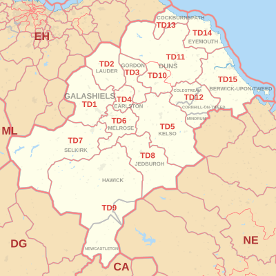
The TD postcode area, also known as the Galashiels postcode area,[2] is a group of fifteen postcode districts in south-east Scotland and the far north-east of England, within seventeen post towns. These cover most of the Scottish Borders council area (including Galashiels, Lauder, Gordon, Earlston, Kelso, Melrose, Selkirk, Jedburgh, Hawick, Newcastleton, Duns, Coldstream, Cockburnspath and Eyemouth) and the northernmost part of Northumberland (including Berwick-upon-Tweed, Cornhill-on-Tweed and Mindrum), plus a part of south-eastern East Lothian and a very small part of Cumbria.

Galashiels
TD is located in the United Kingdom
TD
TD
Coordinates: 55°36′50″N 2°31′37″W / 55.614°N 2.527°W / 55.614; -2.527
CountryUnited Kingdom
Postcode area
TD
Postcode area name
Galashiels
Post towns17
Postcode districts15
Postcode sectors35
Postcodes (live)4,476
Postcodes (total)5,227
Statistics as at May 2020[1]

The letters in the postcode are derived from Tweeddale. The TD postcode area is the smallest by population.[3]

Coverage edit

The approximate coverage of the postcode districts:

Postcode district Post town Coverage Local authority area(s)
TD1 GALASHIELS Galashiels, Tweedbank, Boleside, Clovenfords, Caddonfoot, Fountainhall, Stow, Blainslie, Lindean Scottish Borders
TD2 LAUDER Lauder, Oxton Scottish Borders
TD3 GORDON Gordon, Houndslow, Westruther Scottish Borders
TD4 EARLSTON Earlston, Legerwood, Redpath Scottish Borders
TD5 KELSO Kelso, Ednam, Stichill, Eccles, Hume, Nenthorn, Smailholm, Roxburgh, Eckford, Heiton, Morebattle, Hownam, Linton, Town Yetholm, Kirk Yetholm, Lempitlaw, Sprouston, Makerstoun Scottish Borders
TD6 MELROSE Melrose, Darnick, Gattonside, Newstead, Eildon, Newtown St Boswells, St Boswells, Bowden, Lilliesleaf, Maxton, Clintmains, Dryburgh, Bemersyde Scottish Borders
TD7 SELKIRK Selkirk, Lindean, Midlem, Ashkirk, Philiphaugh, Broadmeadows, Yarrowford, Yarrow, Ettrick, St Mary's Loch, Ettrickbridge Scottish Borders
TD8 JEDBURGH Jedburgh, Ancrum, Camptown, Crailing, Jed Valley, Nisbet, Oxnam, Lanton Scottish Borders
TD9 HAWICK Hawick, Bedrule, Bonchester Bridge, Chesters, Denholm, Newmill-on-Teviot, Roberton, Wilton Dean, Craik, Minto Scottish Borders
NEWCASTLETON Newcastleton, Kershopefoot Scottish Borders, Cumberland
TD10 DUNS Greenlaw, Polwarth Scottish Borders
TD11 DUNS Duns, Chirnside, Allanton, Cranshaws, Longformacus, Fogo, Gavinton, Swinton, Whitsome, Edrom, Preston, Abbey St Bathans, Grantshouse, Chirnsidebridge Scottish Borders, East Lothian
TD12 COLDSTREAM Coldstream, Leitholm, Birgham, Lennel Scottish Borders
CORNHILL-ON-TWEED Cornhill-on-Tweed, Branxton, Crookham, Etal, Carham, Wark on Tweed, Northumberland
MINDRUM Mindrum, Kilham
TD13 COCKBURNSPATH Cockburnspath, Oldhamstocks, Dunglass, Cove Scottish Borders, East Lothian
TD14 EYEMOUTH Eyemouth, Coldingham, St Abbs, Ayton, Burnmouth, Reston, Auchencrow, Houndwood Scottish Borders
TD15 BERWICK-UPON-TWEED Foulden, Mordington, Lamberton, Paxton, Fishwick, Ladykirk, Norham, Ford, Cheswick, Holy Island, Hutton, Horncliffe, Duddo, Fenwick, Ancroft, Lowick, Scremerston, Spittal, Holburn Northumberland, Scottish Borders

Map edit

Template:Attached KML/TD postcode area
KML is from Wikidata
 CA postcode areaDG postcode areaEH postcode areaML postcode areaNE postcode area
TD postcode area map, showing postcode districts in red and post towns in grey text, with links to nearby CA, DG, EH, ML and NE postcode areas.

See also edit

References edit

  1. ^ "ONS Postcode Directory Version Notes" (ZIP). National Statistics Postcode Products. Office for National Statistics. May 2020. Table 2. Retrieved 19 June 2020. Coordinates from mean of unit postcode points, "Code-Point Open". OS OpenData. Ordnance Survey. February 2012. Retrieved 21 April 2012.
  2. ^ Royal Mail, Address Management Guide, (2004)
  3. ^ "FOI request: Population for every postcode district in England and Wales". The National Archives. Archived from the original on 5 January 2016. Retrieved 26 April 2021.{{cite web}}: CS1 maint: bot: original URL status unknown (link)

External links edit

  • Royal Mail's Postcode Address File
  • A quick introduction to Royal Mail's Postcode Address File (PAF) Archived 26 September 2018 at the Wayback Machine