
KNOWPIA
WELCOME TO KNOWPIA

TIROS-N 
Summary
TIROS-N satellite is the first of the TIROS-N series. It is a weather satellite launched on 13 October 1978.[2] It was designed to become operational during 2 years. Its mass is 734 kilograms.[2] Its perigee to Earth is 829 kilometers. Its apogee is 845 kilometers away from Earth. Its inclination is 98.70°. It was managed by the U.S. National Oceanic and Atmospheric Administration (NOAA); designed and launched by NASA. The spacecraft was 3-axis stabilized.[2] TIROS-N was operated for 868 days until deactivated by NOAA on 27 February 1981.[3]
 | |||||||||||||||||||||||||||||
| Mission type | Weather | ||||||||||||||||||||||||||||
|---|---|---|---|---|---|---|---|---|---|---|---|---|---|---|---|---|---|---|---|---|---|---|---|---|---|---|---|---|---|
| Operator | NOAA | ||||||||||||||||||||||||||||
| COSPAR ID | 1978-096A | ||||||||||||||||||||||||||||
| SATCAT no. | 11060 | ||||||||||||||||||||||||||||
| Mission duration | 2 years (planned) 868 days (achieved) | ||||||||||||||||||||||||||||
| Spacecraft properties | |||||||||||||||||||||||||||||
| Spacecraft | TIROS-N | ||||||||||||||||||||||||||||
| Launch mass | 734 kg (1,618 lb) | ||||||||||||||||||||||||||||
| Start of mission | |||||||||||||||||||||||||||||
| Launch date | 13 October 1978, 11:23:00 UTC[1] | ||||||||||||||||||||||||||||
| Rocket | Atlas F | ||||||||||||||||||||||||||||
| Launch site | Vandenberg Air Force Base | ||||||||||||||||||||||||||||
| End of mission | |||||||||||||||||||||||||||||
| Deactivated | 27 February 1981 | ||||||||||||||||||||||||||||
| Orbital parameters | |||||||||||||||||||||||||||||
| Reference system | Geocentric orbit | ||||||||||||||||||||||||||||
| Regime | Sun-synchronous orbit | ||||||||||||||||||||||||||||
| Perigee altitude | 829 km (515 mi) | ||||||||||||||||||||||||||||
| Apogee altitude | 845 km (525 mi) | ||||||||||||||||||||||||||||
| Inclination | 98.70° | ||||||||||||||||||||||||||||
| Period | 101.70 minutes | ||||||||||||||||||||||||||||
| |||||||||||||||||||||||||||||
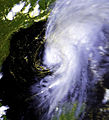
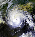
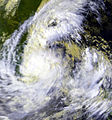
Gallery of cyclones captured by this satellite edit
-
 Typhoon Tip (14 October 1979) 2 days after reaching peak intensity.
 -
-

-
-
-


References edit
- ^ "Display: TIROS-N 1978-096A". nssdca.gsfc.nasa.gov. NASA. 14 May 2020. Retrieved 27 December 2020.
 This article incorporates text from this source, which is in the public domain.
- ^ a b c "Tiros N". Archived from the original on 24 June 2014. Retrieved 10 May 2014.
- ^ "TIROS-N/NOAA Program - 1978-1986". NASA. Archived from the original on 9 December 2014. Retrieved 10 May 2014. This article incorporates text from this source, which is in the public domain.
External links edit
- ITOS/TIROS-N/ATN (NOAA) series