


Summary
Tabeguache Peak is one of the fourteeners of the US state of Colorado. It is a near neighbor of the higher peak Mount Shavano, which lies approximately 1/2 mile (approximately 1 km) to the southeast, and is close to being a subpeak of the latter.[6] According to William Bright an American Linguist specialized in Native American and South Asian languages and descriptive linguistics it is pronounced "TAB-uh-wahch" (/tæbəwɑːtʃ/ ⓘ).[7] According to Mountaineer Louis Dawson the name is pronounced "tab-uh-wash," with the accent on the first syllable.[8] It lies just east of the Continental Divide and just west of the Arkansas River, in the south-central part of the Sawatch Range. It is located within the San Isabel National Forest and is in Chaffee County.
| Tabeguache Peak | |
|---|---|
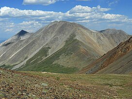 Tabeguache Peak viewed from the west | |
| Highest point | |
| Elevation | 14,162 ft (4,317 m)[1][2] |
| Prominence | 455 ft (139 m)[3] |
| Isolation | 0.75 mi (1.21 km)[3] |
| Listing | Colorado Fourteener 25th |
| Coordinates | 38°37′32″N 106°15′03″W / 38.6254994°N 106.250855°W[1] |
| Geography | |
 Tabeguache Peak | |
| Location | Chaffee County, Colorado, U.S.[4] |
| Parent range | Sawatch Range[3] |
| Topo map | USGS 7.5' topographic map Saint Elmo, Colorado[1] |
| Climbing | |
| Easiest route | Via Mt. Shavano: Hike, class 2[5] |
The mountain is named for the Tabeguache band of the Utes. "Tabaguache" means 'People of Sun Mountain', from "Tava" meaning 'sun.'[9][10]
Climate edit
| Climate data for Tabeguache Peak 38.6267 N, 106.2516 W, Elevation: 13,648 ft (4,160 m) (1991–2020 normals) | |||||||||||||
|---|---|---|---|---|---|---|---|---|---|---|---|---|---|
| Month | Jan | Feb | Mar | Apr | May | Jun | Jul | Aug | Sep | Oct | Nov | Dec | Year |
| Mean daily maximum °F (°C) | 22.1 (−5.5) |
21.5 (−5.8) |
26.4 (−3.1) |
31.6 (−0.2) |
40.4 (4.7) |
52.2 (11.2) |
57.5 (14.2) |
55.4 (13.0) |
49.4 (9.7) |
39.2 (4.0) |
28.6 (−1.9) |
22.4 (−5.3) |
37.2 (2.9) |
| Daily mean °F (°C) | 10.4 (−12.0) |
9.5 (−12.5) |
13.9 (−10.1) |
18.7 (−7.4) |
27.4 (−2.6) |
38.0 (3.3) |
43.4 (6.3) |
42.0 (5.6) |
36.0 (2.2) |
26.6 (−3.0) |
17.4 (−8.1) |
11.0 (−11.7) |
24.5 (−4.2) |
| Mean daily minimum °F (°C) | −1.3 (−18.5) |
−2.5 (−19.2) |
1.4 (−17.0) |
5.8 (−14.6) |
14.4 (−9.8) |
23.7 (−4.6) |
29.4 (−1.4) |
28.5 (−1.9) |
22.7 (−5.2) |
13.9 (−10.1) |
6.2 (−14.3) |
−0.4 (−18.0) |
11.8 (−11.2) |
| Average precipitation inches (mm) | 3.22 (82) |
3.27 (83) |
3.52 (89) |
4.28 (109) |
2.84 (72) |
1.23 (31) |
2.88 (73) |
2.49 (63) |
2.20 (56) |
2.37 (60) |
2.80 (71) |
3.00 (76) |
34.1 (865) |
| Source: PRISM Climate Group[11] | |||||||||||||
Historical names edit
- Mogwatavungwantsingwu
- Mount Tabequache
- Tabeguache Mountain
- Tageguache Peak – 1982 [4]
See also edit
References edit
- ^ a b c "TABEGUACHE". NGS Data Sheet. National Geodetic Survey, National Oceanic and Atmospheric Administration, United States Department of Commerce. Retrieved October 22, 2014.
- ^ The elevation of Tabeguache Peak includes an adjustment of +2.107 m (+6.91 ft) from NGVD 29 to NAVD 88.
- ^ a b c "Tabeguache Peak, Colorado". Peakbagger.com. Retrieved October 22, 2014.
- ^ a b "Tabeguache Peak". Geographic Names Information System. United States Geological Survey, United States Department of the Interior. Retrieved October 29, 2014.
- ^ "Tabeguache Peak Routes". 14ers.com.
- ^ The topographic prominence of Tabeguache Peak is only 435 ft (133 m), and the usual cutoff for independence is 300 ft (91 m).
- ^ William Bright (2004). Colorado Place Names. Johnson Books. ISBN 978-1555663339.
- ^ Louis W. Dawson II (1994). Dawson's Guide to Colorado's Fourteeners, Volume 1. Blue Clover Press. ISBN 0-9628867-1-8.
- ^ Eichler, George R. (1977). Colorado Place Names. Boulder, Colorado: Johnson Publishing Company. LCCN 77-089726.
- ^ Kaelin, Celinda Reynolds (2002). "Tava: A Ute Cultural History". Archived from the original on 24 September 2017.
- ^ "PRISM Climate Group, Oregon State University". PRISM Climate Group, Oregon State University. Retrieved October 10, 2023.
To find the table data on the PRISM website, start by clicking Coordinates (under Location); copy Latitude and Longitude figures from top of table; click Zoom to location; click Precipitation, Minimum temp, Mean temp, Maximum temp; click 30-year normals, 1991-2020; click 800m; click Retrieve Time Series button.
External links edit
 Definitions from Wiktionary
 Media from Commons
 News from Wikinews
 Quotations from Wikiquote
 Texts from Wikisource
 Textbooks from Wikibooks
 Resources from Wikiversity
- "Tabeguache Peak". 14ers.com.
- Mount Shavano at the Colorado Fourteeners Initiative
- Mount Shavano on fourteeners.org
- "Mount Shavano, Colorado". Peakbagger.com.