


Summary
Tachileik (also spelt Tachilek; Burmese: တာချီလိတ်, [tà tɕʰì leɪʔ]; Shan: တႃႈၶီႈလဵၵ်း, [tɑ᷆.kʰi᷆.lék]; Thai: ท่าขี้เหล็ก, RTGS: Tha Khilek, [tʰâː.kʰîː.lèk]) is a border town in Shan State of eastern Myanmar. It is the administrative seat of Tachileik Township and Tachileik District and most populated city in eastern Shan State with 51,553 residents per 2014 census count, ahead of Kyaing Tong, but only 4th statewide.[1] It faces Mae Sai in Thailand, and is home to one of Myanmar's seven official border trade posts with Thailand.
Tachileik
တာချီလိတ်မြို့ | |
|---|---|
Town | |
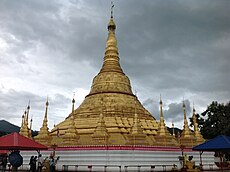
![Skyline of Tachileik on the Daen Lao Range, seen from Thailand's Wat Phra That Doi Wao [th]](http://upload.wikimedia.org/wikipedia/commons/thumb/0/01/Wat_Phra_Dhatu_Doi_Wao_%E0%B8%A7%E0%B8%B1%E0%B8%94%E0%B8%9E%E0%B8%A3%E0%B8%B0%E0%B8%98%E0%B8%B2%E0%B8%95%E0%B8%B8%E0%B8%94%E0%B8%AD%E0%B8%A2%E0%B9%80%E0%B8%A7%E0%B8%B2_%28October_2021%29_-_img_07.jpg/250px-Wat_Phra_Dhatu_Doi_Wao_%E0%B8%A7%E0%B8%B1%E0%B8%94%E0%B8%9E%E0%B8%A3%E0%B8%B0%E0%B8%98%E0%B8%B2%E0%B8%95%E0%B8%B8%E0%B8%94%E0%B8%AD%E0%B8%A2%E0%B9%80%E0%B8%A7%E0%B8%B2_%28October_2021%29_-_img_07.jpg) Skyline of Tachileik on the Daen Lao Range, seen from Thailand's Wat Phra That Doi Wao | |
 Tachileik Location in Burma | |
| Coordinates: 20°27′10″N 99°53′45″E / 20.45278°N 99.89583°E | |
| Country | |
| Division | |
| Admin. district | Tachileik |
| Admin. township | Tachileik Township |
| Population (2014) | 51,553 |
| • Ethnicities | Shan |
| • Religions | Buddhism |
| Time zone | UTC+6.30 (MST) |
History edit
Tachileik was a border crossing used in the opium trade from the Golden Triangle[2] and was the town that the drug lord Khun Sa used to live in.[3]
On 24 March 2011 a magnitude 6.8 earthquake struck the region very close to Tachileik. It caused some damage as far away as Chiang Mai.
On 24 March 2012 a bomb wounded 2 people at the Regina Hotel golf course in Tachileik, followed by a second bomb that exploded an hour later.[4]
Economy edit
The border trade post with Thailand opened on 16 March 1996.[5] In 2022, total trade volume at the border post stood at US$130.664 million.[6]
In 2009, it was reported that Tachileik vendors openly sold endangered animal parts.[7] Located immediately following the bridge that divides Myanmar and Thailand is a marketplace[8][9] that sells a large variety of products, including DVDs, perfume, clothing, luggage and wine.
Tachileik once had the reputation as a distribution nexus for heroin and ya ba (methamphetamine pills) moving from rural Myanmar to the world market.
Tourism edit
The main tourist attraction is a large gold-coloured stupa,[3] which, among other things, showcases the seven days of the week. The idea is for a pilgrim to go to the spot which has the day he/she was born known as the planetary post, and do a simple spiritual worship.
West of town there are hiking trails, though currently they are designated for locals, not for tourists. There is an Akha hill tribe, over an hour's walk north-west of Tachilek called Ho Yu. There are no maps and no guides for such excursions, and Burmese authorities frown on foreign visitors leaving the beaten track.
Pasa Wildlife Reserve is located in the eastern side of the district.
Transport edit
Tachileik has an airport which links to four Burmese cities – Yangon, Mandalay, Taungyi Heho and Kengtung.[10] By road Tachileik is connected to Kengtung, which lies 106 km (66 miles) to the north, by the Asian Highway route AH2, and via Kengtung west to Taunggyi, capital of Shan State, and east by route AH3 to Mongla and on to Yunnan Province, China.[11][12]
Climate edit
| Climate data for Tachileik | |||||||||||||
|---|---|---|---|---|---|---|---|---|---|---|---|---|---|
| Month | Jan | Feb | Mar | Apr | May | Jun | Jul | Aug | Sep | Oct | Nov | Dec | Year |
| Mean daily maximum °C (°F) | 28 (82) |
31 (88) |
33 (91) |
35 (95) |
33 (91) |
32 (90) |
31 (88) |
31 (88) |
31 (88) |
30 (86) |
28 (82) |
26 (79) |
31 (87) |
| Mean daily minimum °C (°F) | 12 (54) |
13 (55) |
16 (61) |
20 (68) |
22 (72) |
23 (73) |
23 (73) |
23 (73) |
22 (72) |
20 (68) |
17 (63) |
13 (55) |
19 (66) |
| Average rainfall mm (inches) | 15 (0.6) |
8 (0.3) |
20 (0.8) |
73 (2.9) |
186 (7.3) |
204 (8.0) |
276 (10.9) |
342 (13.5) |
224 (8.8) |
128 (5.0) |
59 (2.3) |
22 (0.9) |
1,557 (61.3) |
| Average rainy days | 5 | 3 | 3 | 10 | 18 | 21 | 23 | 25 | 19 | 14 | 8 | 6 | 155 |
| Mean monthly sunshine hours | 248 | 252 | 248 | 240 | 217 | 150 | 124 | 155 | 180 | 186 | 210 | 217 | 2,427 |
| Source: World Climate Guide | |||||||||||||
Border crossing edit

Tachileik can be accessed from the Thai town of Mae Sai, which sits directly south on the other side of the small Mae Sai River. There are two bridges that provide access between Mae Sai and Tachilek.
It is a porous border and is not difficult to wade across the river. Burmese merchants used to be able to cross over and do business in Mae Sai for days at a time. The border is also a popular destination for Westerners who either reside in or are visiting Thailand and who need to get their passport visas renewed.

There is no charge for a 'visa run' going from Thailand to Burma on the Thai side, but there is a charge of US$10 or 500 Thai Baht on the Burmese side.[13]
Health care edit
- Tachileik General Hospital
Notes edit
- ^ "Myanmar: Regions, States, Major Cities & Towns - Population Statistics, Maps, Charts, Weather and Web Information".
- ^ here
- ^ a b Chien, Choo Tse (2004) "Border Areas & Into Burma Photo Gallery"
- ^ "Two wounded in Myanmar golf course bombing". Hindustan Times. Agence France-Presse. 24 March 2012. Archived from the original on 27 March 2012. Retrieved 27 March 2012.
- ^ "Border Trade Posts". Ministry of Commerce. Retrieved 2023-03-05.
- ^ "Border Trade Data". Ministry of Commerce. 2023-02-24. Retrieved 2023-03-05.
- ^ Richard S. Ehrlich (5 December 2009). "Endangered animal skins and iPods. A day trip to Tachilek, Myanmar". CNN. Turner Broadcasting System, Inc. Retrieved 26 August 2012.
- ^ John P Seely (2003–2012). "Tachilek: Gateway to Myanmar". John P Seely.com. John P Seely. Retrieved 26 August 2012.
- ^ paulandwaralak (28 January 2012). "Tachilek market Burmaover the border from Mae Sai in Thailand". YouTube. Google, Inc. Archived from the original on 2021-12-21. Retrieved 26 August 2012.
- ^ "Time Taken and Distances (Car / Flight / Boat)". myanmartravels.net. Retrieved 2009-03-15.
- ^ "Asian Highway in Myanmar" (PDF). unescap.org. Retrieved 2009-03-15.
- ^ Lawi Weng. "'Yaa-Baa' Bust in Tachilek". The Irrawaddy, March 11, 2009. Archived from the original on 2009-03-15. Retrieved 2009-03-15.
- ^ "Burma, part 2: Checkpoints". the Daily Muse. Retrieved 2009-03-15.
External links edit
 Media related to Tachileik at Wikimedia Commons
 Tachileik travel guide from Wikivoyage
- Satellite map Maplandia
- Picture