


Summary
Tamenglong district (Meitei pronunciation:[b] /tæmɛŋˈlɒŋ/[1]) is one of the 16 districts of Manipur state in northeastern India.[2] In 2011, Tamenglong was the least populous district in Manipur.[3] In 2016, the Nungba subdivision was separated as a separate district.[4]
Tamenglong district | |
|---|---|
 Location in Manipur | |
| Coordinates: 24°59′N 93°29′E / 24.983°N 93.483°E | |
| Country | |
| State | Manipur |
| Headquarters | Tamenglong |
| Area | |
| • Total | 4,391 km2 (1,695 sq mi) |
| Population (2011)[a] | |
| • Total | 170,651 |
| • Density | 39/km2 (100/sq mi) |
| Language(s) | |
| • Official | Meitei (officially called Manipuri)[b][1] |
| • Regional | Rongmei, Liangmai and Zeme, Thadou |
| Time zone | UTC+5:30 (IST) |
| ISO 3166 code | IN-MN-TA |
| Website | tamenglong |
History edit
In 1919, the British Government established four sub-divisions office in Manipur Hills known as North East Sub-Division, North West Sub-Division, South East Sub-Division and South West Sub-Division. The Headquarters of North West Sub-Division was set up at Khunjao, Tamenglong Village (Nriangluang) and Mr. William Shaw was appointed as the Sub-Divisional Officer. In 1923, the headquarters of Northwest sub-division was shifted to the present site known as Tamenglong headquarters some 3 km away from Khunjao. Later the Manipur North West sub-division was renamed as Tamenglong Sub-Division. Tamenglong became a full-fledged district in 1969 and the first Deputy Commissioner was posted.
Geography edit
This district is bounded by Nagaland state and Senapati district on the north, by the Assam state on the west, by the newly created Noney district on the south and by Kangpokpi district (formerly part of Senapati district) on the east. The Tamenglong town is the headquarters of this district. The 2011 district, including the Nungba subdivision, occupies an area of 4391 km.
The district contains virgin forests, exotic orchids, rare and endangered plants, and wildlife. The forests contain tropical evergreen forests, subtropical forests and bamboo brakes. The dense tropical evergreen forests are located along the riversides across the district. Tamenglong is called the Land of the Hornbill as the , Great Pied Hornbill and Indian Pied Hornbill species are found here. Wildflowers include several types of orchids, including epiphytic, lithophytic and terrestrial.
Places of interest edit
Tamenglong district of Manipur has a topography of irregular undulation with turbulent rivers, waterfalls, caves, lakes, and dense tropical forests covering the land.
- Along the river Barak there is a series of seven waterfalls.
- The Tharon cave (Chalem-Ky) is located at about 27 km from the district HQ. The map of the entire cave is engraved and painted on a stone at the main entrance. Archeological excavation of the cave shows connections to the Hoabinhian culture of North Vietnam.
- Zeilad lake at Makoi (Atengba) is associated with a number of pythons, fishes, and water birds. There are several other lakes nearby including Guiphop Zei, Nrou Zei, and Nap-sam Zei.
- Buning Meadow (Npiulong) is located on the western side of Tamei town. A number of well-groomed uneven small mounds as well numerous brooks mark the stretch. In early summer ground orchids and Wild Lilies can be seen in the meadow. The meadow is also home to wild birds and foxes.
- Phelong Village is well known for its Orange production and its taste. Phelong has been one of the major producers of oranges in Tamenglong District.
- Taningjam Village is one of the oldest villages of Tamenglong District. The rivers and Rock Garden are well-known attractions for a visit to the village.
Economy edit
In 2006 the Ministry of Panchayati Raj named Tamenglong one of the country's 250 most backward districts (out of a total of 640).[5] It is one of the three districts in Manipur currently receiving funds from the Backward Regions Grant Fund Programme (BRGF).[5]
Demographics edit
| Year | Pop. | ±% |
|---|---|---|
| 1951 | 33,519 | — |
| 1961 | 37,667 | +12.4% |
| 1971 | 46,034 | +22.2% |
| 1981 | 62,289 | +35.3% |
| 1991 | 86,278 | +38.5% |
| 2001 | 111,499 | +29.2% |
| 2011 | 140,651 | +26.1% |
| 2011 Tamenglong district (includes the present Noney district) Source: Census of India[6] | ||
According to the 2011 census Tamenglong district has a population of 140,651.[2][a] This gives it a ranking of 607th in India (out of a total of 640). The district has a population density of 32 inhabitants per square kilometre (83/sq mi). Its population growth rate over the decade 2001–2011 was 25.69%. Tamenglong has a sex ratio of 953 females for every 1000 males, and a literacy rate of 70.4%. Its population composition as per the 2011 census is as below:
| Population[7] | Percentage
of Total Pop. | |
|---|---|---|
| All Scheduled Tribes | 134,626 | 85.7% |
| Kuki-Zo tribes[c] | 9,330 | 6.6% |
| Naga tribes[d] | 121,701 | 86.5% |
| Old Kuki/Naga[e] | 1,589 | 1.1% |
The majority of the population consists of Kabui Nagas (55.6%) and Kacha Nagas (30.9%).[7]
Administrative divisions edit
The district is divided into three sub-divisions:[9]
- Tamenglong
- Tamei
- Tousem
In December 2016, the Nungba subdivision was separated out as the new Noney district.[4]
Gallery edit
-
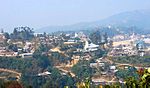 View of town as seen from Gaidai foothill
 -
 Farmland Lake.
 -
 Raengon Bamduan
 -
 Prayer Mountain
 -
 Nriangluang
 -
 Rah Nouh Bung (Ghost Breasts) at Barak
 -
 Asha Naaploih (Asha Rice Pot) at Barak
 -
 The famous Kacha Khou (Mountain) at Magulong


Notable Personalities edit
See also edit
Notes edit
- ^ a b c Includes the Nungba subdivision, which was made a separate district in 2016.
- ^ a b Meitei language (officially known as Manipuri language) is the official language of Manipur. Other regional languages of different places in Manipur may either be predominantly spoken or not in their respective places but "Meitei" is always officially used.
- ^ The Kuki-Zo tribes include Gangte, Hmar, Paite, Simte, Sukte, Thadou, Vaiphei, Zou, and some smaller tribes designated as "Any Kuki" and "Any Lushai (Mizo)".
- ^ The Naga tribes include Angami, Kabui, Kacha Naga, Mao, Maram, Poumai, Sema and Tangkhul.
- ^ The Old Kuki tribes retaining the Kuki classification include: Aimol, Chiru, Kom, Koireng, Kharam, and Ralte. The tribes under the Naga umbrella include: Anal, Chothe, Koirao, Lamkang, Maring, Moyon, Monsang, Purum and Tarao.[8]
References edit
- ^ a b "Report of the Commissioner for linguistic minorities: 47th report (July 2008 to June 2010)" (PDF). Commissioner for Linguistic Minorities, Ministry of Minority Affairs, Government of India. p. 78. Archived from the original (PDF) on 13 May 2012. Retrieved 16 February 2012.
- ^ a b "Tamenglong". 2011 Census of India. Government of India. Archived from the original on 14 September 2017. Retrieved 14 September 2017.
- ^ "District of Manipur". Census2011.co.in. 2011. Retrieved 30 September 2011.
- ^ a b Khelen Thokchom, More districts in Manipur, The Telegraph (Kolkata), 9 December 2016. ProQuest 2290178396
- ^ a b Ministry of Panchayati Raj (8 September 2009). "A Note on the Backward Regions Grant Fund Programme" (PDF). National Institute of Rural Development. Archived from the original (PDF) on 5 April 2012. Retrieved 27 September 2011.
- ^ "A-2 Decadal Variation In Population Since 1901". Censusindia.gov.in. Archived from the original on 1 July 2014.
- ^ a b A-11 Appendix: District wise scheduled tribe population (Appendix), Manipur - 2011, Office of the Registrar General & Census Commissioner, Government of India, 2011
- ^ Kom, Ch. Sekholal (June 2015). "Ethno-nationalism: Competing Micro-nationalist Dissents in Manipur". Social Change. 45 (2): 289–307. doi:10.1177/0049085715574192. ISSN 0049-0857.
- ^ Subdivision & blocks, Tamenglong District Administration, Government of Manipur.
External links edit
- Official website of Tamenglong district