
KNOWPIA
WELCOME TO KNOWPIA

Tanaga (volcano) 
Summary
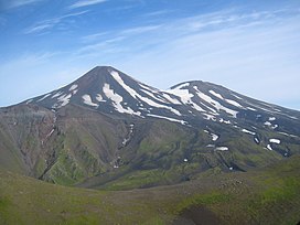
Tanaga (Aleut: Kusuuginax̂)[2][3] is a 5,924-foot (1,806 m) stratovolcano in the Aleutian Range of the U.S. state of Alaska. There have been three known eruptions since 1763. The most recent was in 1914 and produced lava flows. It sits west of another stratovolcano known as Mount Takawangha, which last erupted in 1550.[4]
| Tanaga | |
|---|---|
 Tanaga | |
| Highest point | |
| Elevation | 5,925 ft (1,806 m)[1] |
| Prominence | 5,925 ft (1,806 m)[1] |
| Listing | |
| Coordinates | 51°53′02″N 178°08′29″W / 51.88389°N 178.14139°W |
| Geography | |
 Tanaga Alaska | |
| Location | Tanaga Island, Alaska, U.S. |
| Parent range | Aleutian Range |
| Geology | |
| Mountain type | Stratovolcano |
| Volcanic arc/belt | Aleutian Arc |
| Last eruption | 1914 |
See also edit
External links edit
Tanaga (volcano) at Wikipedia's sister projects
 Definitions from Wiktionary
 Media from Commons
 News from Wikinews
 Quotations from Wikiquote
 Texts from Wikisource
 Textbooks from Wikibooks
 Resources from Wikiversity
- Image of Tanaga
- "Tanaga". Global Volcanism Program. Smithsonian Institution. Retrieved 2021-06-28.
References edit
- ^ a b "Alaska & Hawaii P1500s - the Ultras". PeakList.org. Retrieved 2013-01-06.
- ^ Bergsland, K. (1994). Aleut Dictionary. Fairbanks: Alaska Native Language Center.
- ^ "Tanaga - Introduction". avo.alaska.edu. Retrieved 2020-08-08.
- ^ "Takawangha". Global Volcanism Program. Smithsonian Institution. Retrieved 2021-06-28.