


Summary
Tanegashima (種子島) is one of the Ōsumi Islands belonging to Kagoshima Prefecture, Japan. The island, 444.99 km2 in area, is the second largest of the Ōsumi Islands, and has a population of 33,000 people. Access to the island is by ferry, or by air to New Tanegashima Airport. Administratively, the island is divided into the city, Nishinoomote, and the two towns, Nakatane and Minamitane. The towns belong to Kumage District.
Native name: 種子島 | |
|---|---|
NASA photo of Tanegashima | |
Tanegashima is the easternmost of the Ōsumi Islands, just south of the major island of Kyushu | |
| Geography | |
| Location | East China Sea |
| Coordinates | 30°34′26″N 130°58′52″E / 30.57389°N 130.98111°E |
| Archipelago | Ōsumi Islands |
| Area | 444.99 km2 (171.81 sq mi) |
| Length | 57.2 km (35.54 mi) |
| Coastline | 186 km (115.6 mi) |
| Highest elevation | 282 m (925 ft) |
| Administration | |
Japan | |
| Kagoshima Prefecture | |
| Demographics | |
| Population | 33,000 (2010) |
| Ethnic groups | Japanese |
Geography edit
Tanegashima is the easternmost and the second largest (after Yakushima) of the Ōsumi Islands. It is located approximately 43 kilometres (23 nmi) south of the southern tip of Ōsumi Peninsula in southern Kyushu, or 115 kilometres (62 nmi) south of Kagoshima. The Vincennes Strait (Yakushima Kaikyō) separates it from Yakushima.
The island is of volcanic origin; however, unlike neighboring Yakushima, it presents a flat appearance, with its highest elevation at only 282 metres (925 ft) above sea level. The island has a length of 57 kilometres (31 nmi) and a width ranging from 5 kilometres (2.7 nmi) to 10 kilometres (5.4 nmi). The climate is subtropical. The island, along with neighbouring Yakushima, has been recognised as an Important Bird Area (IBA) by BirdLife International because they support populations of Japanese wood pigeons, Ryukyu green pigeons and Ryukyu robins.[1]
- Gallery
-
 In the vicinity of Inu Castle Coast, Daikoya District
 -
 Town area of Nakatane (中種子町), Kagoshima, Japan
 -
 Weathered rocks near Mt. Iwasaki
 -
 Chikura Caverns
 -
 Cape Kadokura
 -
 Ōsumi islands map


History edit
Tanegashima has a long history of Kofun. Other burials on Tanegashima, namely the Yokomine and Hirota sites, attest to a uniquely well-developed Yayoi period culture at the end of the 4th century AD.[2] The artifacts include magatama, an engraved pendant, and emblems with apparent writing.[3]
During the Nara period, the embryo state of Japan began to make contact with Tanegashima. According to the Nihonshoki, the imperial court hosted a banquet for the islanders of Tanegashima in 677. In 679, the court sent a mission to the island who returned in 681. Other missions to the island mentioned in the book were in 683 and 695. According to the Shoku Nihongi, people from Tane, Yaku, Amami and Dokan (possibly Tokunoshima) came to the imperial court to pay tribute in 699. These activities resulted in the establishment of Tane Province on the island in 702.[4] Tane Province lasted until 824 and was merged into Ōsumi Province.
Sometime around 1140, the whole island of Tanegashima became part of the Shimazu Estate, the largest medieval shōen of Japan. In the early Kamakura period, the positions of the land steward of the Shimazu Estate and the military governor of Ōsumi Province were given to the Shimazu clan. However, the clan lost these positions to the Hōjō clan, the de facto ruler of the shogunate. The Hōjō clan sent the Higo clan as deputy governors. A branch line of the Higo clan made itself autonomous on Tanegashima after the Hōjō clan was annihilated and began to claim the clan name of Tanegashima.[5]
The Tanegashima clan ruled the island until the Meiji restoration. The Tanegashima clan enjoyed a high degree of autonomy until Shimazu unified southern Kyūshū in the late 16th century, and after that, served as a top-ranking retainer to the Satsuma domain. Following the Meiji restoration, the island has been administered as part of Kagoshima Prefecture.
Introduction of firearms into Japan edit
Tanegashima is traditionally known as the site of the introduction of European firearms to Japan in 1543. Until modern times, firearms were colloquially known in Japan as "Tanegashima", due to the belief that they were introduced by the Portuguese on board the first Portuguese ship.[6]
In his memoirs published in 1614, Portuguese adventurer turned author, Fernão Mendes Pinto placed himself in the first landing party, although this claim has since been roundly discredited and in fact contradicts his claims to have been in Burma at the time. The two Portuguese traders, António Mota and Francisco Zeimoto, should actually be credited as the first Europeans to introduce firearms. However, Mendes Pinto does appear to have visited Tanegashima soon thereafter. The Europeans had arrived to trade, not only guns, but also soap, tobacco and other goods unknown in medieval Japan, for Japanese goods.
During the Muromachi period, Tanegashima functioned as a relay station for one of the main routes of Chinese trade that connected Sakai to Ningbo. The Tanegashima clan cooperated with the Hosokawa clan, one of two powers who controlled Chinese trade. The clan also maintained a firm connection with the Honnō-ji Temple of Kyoto. These account for the rapid spread of firearms from Tanegashima to central Japan.[7]
- Gallery
-
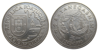 Portuguese escudo commemorating the Portuguese arrival at Tanegashima
 -
 First Westerners in Japan in 1542


Knife industry edit
Edge tools (particularly knives and scissors) made in Tanegashima are famous traditional handicrafts in Japan. Craftsmen in Tanegashima have kept alive traditional techniques for forging and sharpening iron tools. Tanegashima is also famous as the center of iron sand production. The technique has been around since about 1185 when the Taira clan were exiled here from Kyoto by Minamoto no Yoritomo, taking with them craftsmen and chefs from Kyoto. The people of the island speak with a Kyoto accent even now, rather than a Kyūshū or Kagoshima accent, despite its proximity to Kyūshū.[citation needed] These craftsmen were the original users of the distinct techniques used for forging and sharpening. The technique is unique in the world, and produces such tools as "Tanegashima Hōchō" (Tanegashima knives), used by chefs, and "Tane-basami" (Tanegashima scissors), preferred by many for the art of Bonsai. Nevertheless the local population has fallen from over fifty thousand in 1970 to just twenty-eight thousand today, in spite of tourism and space industries, putting traditional crafts at risk.
- Gallery
-
 Nishinoomote City on Tanegashima
 -
 Tanegashima government building
 -
 Nishinoomote Minato Ward from "New Satsuma" (mid December 2012)


Tanegashima Space Center edit
The Tanegashima Space Center is Japan's largest space development center. It is run by JAXA, the Japan Aerospace Exploration Agency and is located at the southeastern end of Tanegashima. It was established in 1969 when the National Space Development Agency of Japan (NASDA) was formed. Activities include assembly, testing, launching and tracking satellites, as well as rocket engine firing tests. Activity includes orbital launches of the H-IIA rockets from the Yoshinobu Launch Complex.
The Space Science and Technology Museum is near the TSC. It offers an intricate view of rocket history and technology in Japan. Though most of the displays are in Japanese, there are English tour pamphlets available.
- Gallery
-
 Full view of the Yoshinobu Launch Complex during roll out of the H-IIA rocket in February 2014
 -
 Overlooking the Osaki Range, surrounded by green mountains and the sea of coral reefs.
 -
 Space Science and Technology Museum
 -
 The H-IIA F11 launch vehicle lifting off from Tanegashima Space Center
 -
 A Mitsubishi Heavy Industries (MHI) H-IIA rocket at TSC


Climate edit
Tanegashima has a humid subtropical climate (Köppen climate classification Cfa) with hot, humid summers and mild winters. Precipitation is high throughout the year, but is highest in the months of May, June and September.
| Climate data for Tanegashima (1991−2020 normals, extremes 1948−present) | |||||||||||||
|---|---|---|---|---|---|---|---|---|---|---|---|---|---|
| Month | Jan | Feb | Mar | Apr | May | Jun | Jul | Aug | Sep | Oct | Nov | Dec | Year |
| Record high °C (°F) | 24.4 (75.9) |
25.6 (78.1) |
26.9 (80.4) |
28.1 (82.6) |
30.6 (87.1) |
32.7 (90.9) |
34.9 (94.8) |
35.9 (96.6) |
34.1 (93.4) |
31.3 (88.3) |
28.8 (83.8) |
27.2 (81.0) |
35.9 (96.6) |
| Mean daily maximum °C (°F) | 14.2 (57.6) |
15.2 (59.4) |
17.6 (63.7) |
21.0 (69.8) |
24.1 (75.4) |
26.8 (80.2) |
30.4 (86.7) |
31.0 (87.8) |
29.1 (84.4) |
25.1 (77.2) |
21.1 (70.0) |
16.7 (62.1) |
22.7 (72.9) |
| Daily mean °C (°F) | 11.7 (53.1) |
12.3 (54.1) |
14.5 (58.1) |
17.8 (64.0) |
21.2 (70.2) |
24.0 (75.2) |
27.5 (81.5) |
28.1 (82.6) |
26.2 (79.2) |
22.3 (72.1) |
18.1 (64.6) |
13.8 (56.8) |
19.8 (67.6) |
| Mean daily minimum °C (°F) | 8.5 (47.3) |
9.0 (48.2) |
11.1 (52.0) |
14.5 (58.1) |
18.1 (64.6) |
21.3 (70.3) |
25.1 (77.2) |
25.7 (78.3) |
23.6 (74.5) |
19.5 (67.1) |
14.9 (58.8) |
10.5 (50.9) |
16.8 (62.3) |
| Record low °C (°F) | 0.0 (32.0) |
−0.6 (30.9) |
2.1 (35.8) |
4.5 (40.1) |
10.0 (50.0) |
15.2 (59.4) |
17.5 (63.5) |
20.6 (69.1) |
14.9 (58.8) |
10.3 (50.5) |
4.5 (40.1) |
2.6 (36.7) |
−0.6 (30.9) |
| Average precipitation mm (inches) | 96.5 (3.80) |
122.5 (4.82) |
160.4 (6.31) |
198.0 (7.80) |
233.3 (9.19) |
556.4 (21.91) |
261.7 (10.30) |
188.7 (7.43) |
293.2 (11.54) |
194.5 (7.66) |
134.8 (5.31) |
92.7 (3.65) |
2,532.5 (99.70) |
| Average rainy days | 9.5 | 10.3 | 12.6 | 10.8 | 11.1 | 17.0 | 9.6 | 11.0 | 11.6 | 9.3 | 9.2 | 8.2 | 130.2 |
| Average relative humidity (%) | 65 | 66 | 69 | 71 | 76 | 84 | 83 | 81 | 79 | 73 | 69 | 65 | 73 |
| Mean monthly sunshine hours | 107.1 | 114.9 | 140.1 | 163.1 | 158.5 | 114.7 | 222.7 | 222.8 | 166.6 | 157.9 | 129.7 | 119.4 | 1,822 |
| Source 1: JMA[8] | |||||||||||||
| Source 2: JMA[9] | |||||||||||||
Sporting events edit
The Tanegashima "Rocket Marathon" takes place in March each year.[10]
Notable people edit
- Miyu Uehara – gravure idol and TV personality
- Kōbō Kenichi – sumo wrestler
- Wakashimazu Mutsuo – sumo wrestler
References edit
- ^ "Yakushima and Tanegashima islands". BirdLife Data Zone. BirdLife International. 2021. Retrieved 7 February 2021.
- ^ "Hirota". archaeology.jp. Retrieved 2018-04-22.
- ^ "Ancient Japanese writing symbols [From the Golden Stamp to Documents from the Shoso-in]|Special Exhibitions|Exhibitions|National Museum of Japanese History". Archived from the original on 2013-07-29. Retrieved 2013-09-30.
- ^ Suzuki Yasutami 鈴木靖民 (1997). "Nantō-jin no raichō wo meguru kisoteki kōsatsu 南島人の来朝をめぐる基礎的考察". Higashi Ajia to Nihon 東アジアと日本 (in Japanese). pp. 347–398.
- ^ Kamiyaku-chō kyōdoshi henshū-iinkai 上屋久町郷土誌編集委員会, ed. (1984). Kamiyaku-chō kyōdoshi 上屋久町郷土誌. Kamiyaku-chō Kyōiku-iinkai 上屋久町教育委員会.
- ^ Sansom, George (1961). A History of Japan, 1334–1615. Stanford University Press. p. 263. ISBN 0804705259.
- ^ Yara Ken'ichirō 屋良健一郎 (2012). "Chūsei kōki no Tanegashima-shi to minami Kyūshū kaiiki 中世後期の種子島氏と南九州海域". Shigaku-zasshi 史学雑誌. 121 (11): 1–36.
- ^ 観測史上1~10位の値(年間を通じての値). JMA. Retrieved February 18, 2022.
- ^ 気象庁 / 平年値(年・月ごとの値). JMA. Retrieved February 18, 2022.
- ^ JAXA March 2005 News
Sources edit
- Lidon, Olof. Tanegashima: The Arrival of Europe in Japan, NIAS Press (2002) ISBN 8791114128
External links edit
 Tanegashima travel guide from Wikivoyage
 Geographic data related to Tanegashima at OpenStreetMap