


Summary
The Tanggula (Chinese: 唐古拉山, p Tánggǔlāshān, or 唐古拉山脉, p Tánggǔlāshānmài), Tangla, Tanglha, or Dangla Mountains (Tibetan: གདང་ལ་།, w Gdang La, z Dang La) is a mountain range in the central part of the Qinghai-Tibet Plateau in Tibet.[1] Administratively, the range is in the Nagqu Prefecture of the Tibet Autonomous Region, with the central section extending into the Tanggula Town and the eastern section entering the Yushu Tibetan Autonomous Prefecture of Qinghai province.
| Tanggula Mountains | |
|---|---|
| Tangla, Tanglha, Dangla Mountains | |
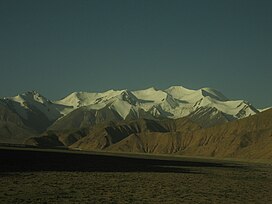 Tanggula Mountains viewed from Qinghai. | |
| Highest point | |
| Peak | Geladaindong Peak |
| Elevation | 6,621 m (21,722 ft) |
| Geography | |
| Country | |
| Province/Region | Qinghai and Tibet Autonomous Region |
| Range coordinates | 33°30′00″N 91°04′12″E / 33.50000°N 91.07000°E |
Tanggula is the source of the Ulan Moron and Dangqu Rivers, the geographic headwaters of the Yangtze River. It functions as a dividing range between the basin of the Yangtze in the north and the endorheic basin of northeastern Tibet in the south.
Overview edit
The elevations of the main ridge average over 5,000 m (16,404 ft). The Yangtze River originates in this mountain range; Geladandong, 6,621 metres or 21,722 feet high, located in Tanggula Town, is the tallest peak in the range.[2][3]
The Qinghai-Tibet Highway and the Qinghai-Tibet Railway cross the Tanggula Mountains at Tanggula Mountain Pass. This is the highest point of the Qinghai-Tibet Railway, and the highest point of any railway in the world, at 5,072 metres (16,640 feet) above sea level.[4] On account of snow and occasional road accidents, highway closures and concomitant traffic delays are not uncommon.[5]
The mountains lie within the Tibetan Plateau alpine shrub and meadows ecoregion.[6]
See also edit
References edit
- ^ "Tanggula Mountains". Encyclopædia Britannica. Retrieved 2007-07-03.
- ^ "Desperate Times at the Headwaters of the Yangtze". Archived from the original on 2007-10-09. Retrieved 2007-07-03.
- ^ Yongjian, Ding; Zhongqin, Li; Shiyin, Liu; Xinzhi, Yu (January 20, 2017). "Glacioclimatological features in the Tanggula mountains, China". Annals of Glaciology. 16: 1–6. doi:10.3189/1992AoG16-1-1-6. ISSN 0260-3055. S2CID 129888580.
- ^ "New height of world's railway born in Tibet". China View. Archived from the original on September 13, 2005. Retrieved 2007-07-03.
- ^ Plateau traffic jam
- ^ Olson, D. M, E. Dinerstein; et al. (2001). "Terrestrial Ecoregions of the World: A New Map of Life on Earth". BioScience. 51 (11): 933–938. doi:10.1641/0006-3568(2001)051[0933:TEOTWA]2.0.CO;2.
{{cite journal}}: CS1 maint: multiple names: authors list (link)
Further reading edit
- Duan, Hong-yu; Yao, Xiao-jun; Liu, Shi-yin; Gao, Yong-peng; Qi, Miao-miao; Liu, Juan; Zhang, Da-hong; Li, Xiao-feng (2019-11-01). "Glacier change in the Tanggula Mountains, Tibetan Plateau, in 1969–2015". Journal of Mountain Science. 16 (11): 2663–2678. doi:10.1007/s11629-018-5011-5. S2CID 201716065.
- Wang, Jing; Wang, Chao; Tang, Yixian; Zhang, Hong; Duan, Wei; Dong, Longkai (2021). "Investigation for the Surface Deformation of Tanggula Mountain Permafrost Using Distributed Scatterer INSAR". 2021 IEEE International Geoscience and Remote Sensing Symposium IGARSS. pp. 5358–5361. doi:10.1109/IGARSS47720.2021.9553890. ISBN 978-1-6654-0369-6. S2CID 238751460.