


Summary
The Tarlac River is a river in Central Luzon Philippines, it is the longest tributary of the Agno River with a total length of 95.2 km (59.2 mi) covering a drainage area of 1,900 square kilometres (730 sq mi) traversing the provinces of Tarlac and Pangasinan.[1] The river originates around the vicinity of Mount Pinatubo and empties itself into the Agno River at Poponto Swamp located between the boundaries of Tarlac and Pangasinan. It was formerly the site of traditional balsa or bamboo raft riding, until the river was heavily silted by sticky lahar or mud flow brought by the eruption of Mount Pinatubo on June 15, 1991, filling the river with over 10 feet (3.0 m) of lahar. Its main tributary is the O'Donnel River in Santa Lucia, Capas, Tarlac.
| Tarlac River | |
|---|---|
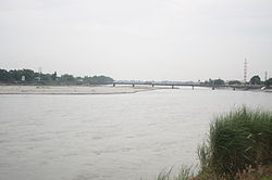 The Aquino Bridge is one of the two bridges constructed across the Tarlac River in Tarlac City to connect the western portion of the city to the Poblacion Area. | |
 Tarlac River mouth  Tarlac River (Philippines) | |
| Location | |
| Country | Philippines |
| Region | Central Luzon |
| Province | |
| Physical characteristics | |
| Source | |
| • location | Mount Pinatubo, Central Luzon |
| • coordinates | 15°9′29.16″N 120°20′52.8″E / 15.1581000°N 120.348000°E |
| • elevation | 4,875 ft (1,486 m) |
| Mouth | Poponto Swamp Agno River |
• location | Bayambang, Pangasinan |
• coordinates | 15°45′29.232″N 120°27′4.464″E / 15.75812000°N 120.45124000°E |
| Length | 95.2 km (59.2 mi) |
| Basin size | 1,900 km2 (730 sq mi) |
| Discharge | |
| • location | Agno River |
| Basin features | |
| River system | Tarlac–Poponto Swamp–Agno |
| Tributaries | |
| • right | O'Donnel River |
The Tarlac River is dammed at Barangay Tibag in Tarlac City where its water is used for irrigation and distributed to the northern and central regions of Tarlac, the rest of the river is now a bed of sand. The river was once a good source of fish and water used for irrigation, the irrigation system now takes just about "all" of the remaining water and distributes it to barangays in Tarlac City such as Matatalaib and Maliwalo. The river bed is also being used as a source of sand and stones that can be used as construction materials.
-
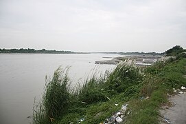 The Tarlac River flowing northward as viewed from the Tarlac City public market
 -
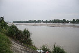 The Tarlac River as viewed from the Tarlac City public market
 -
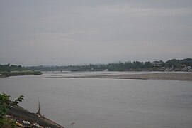 The Tibag Bridge is one of the two bridges constructed across the Tarlac River in Tarlac City to connect the western portion of the city to the Poblacion Area


References edit
- ^ "Hydrometeorology-Agno River Basin". Philippine Atmospheric, Geophysical and Astronomical Services Administration. PAGASA Northern Luzon. Retrieved 9 October 2013.