


Summary
The Tatra Mountains (ⓘ), Tatras, or Tatra (Tatry either in Slovak (pronounced [ˈtatri] ⓘ) or in Polish (pronounced [ˈtatrɨ]) - plurale tantum), are a series of mountains within the Western Carpathians that form a natural border between Slovakia and Poland. They are the highest mountains in the Carpathians. The Tatras are distinct from the Low Tatras (Slovak: Nízke Tatry), a separate Slovak mountain range further south.
| Tatra Mountains | |
|---|---|
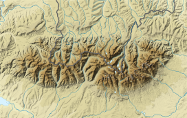
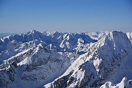
 Bird's-eye view of Western Tatras | |
| Highest point | |
| Peak | Gerlachovský štít |
| Elevation | 2,655 m (8,711 ft) |
| Geography | |
| |
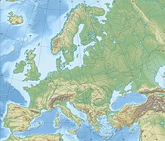
| Countries | Slovakia and Poland |
| Range coordinates | 49°10′N 20°08′E / 49.167°N 20.133°E |
| Parent range | Western Carpathians |
The Tatra Mountains occupy an area of 785 square kilometres (303 sq mi), of which about 610 square kilometres (236 sq mi) (77.7%) lie within Slovakia and about 175 square kilometres (68 sq mi) (22.3%) within Poland. The highest peak, called Gerlachovský štít, at 2,655 m (8710 ft), is located north of Poprad, entirely in Slovakia. The highest point in Poland, Rysy, at 2,500 metres (8,200 ft),[1] is located south of Zakopane, on the border with Slovakia.[2][3]
The Tatras' length, measured from the eastern foothills of the Kobylí vrch (1,109 metres (3,638 ft)) to the southwestern foot of Ostrý vrch (1128 m), in a straight line, is 57 km (35 mi) (or 53 km (33 mi) according to some),[3] and strictly along the main ridge, 80 km (50 mi). The range is only 19 km (12 mi) wide.[4] The main ridge of the Tatras runs from the village of Huty at the western end to the village of Ždiar at the eastern end.
The Tatras are now protected by law by the establishment of the Tatra National Park, Slovakia and the Tatra National Park, Poland, which are jointly entered in UNESCO's World Network of Biosphere Reserves. In 1992, UNESCO jointly designated the Polish and Slovak parks a transboundary biosphere reserve in the World Network of Biosphere Reserves, under its Man and the Biosphere Programme.[5]
Etymology edit
The first written record of the name is from 999, when the Bohemian Duke Boleslaus II, on his deathbed, recalled when the Duchy of Bohemia extended to the Tritri montes. Another mention is in the 1086 document from Henry IV, wherein he referred to the Diocese of Prague with Tritri mountains. Still another is in 1125, where the Kosmas chronicles (Chronica Boemorum) mention the name Tatri.[6]
Machek in 1931 favored the theory of the Polish linguist Rozwadowski with a syllabic r like in the words chrt (Czech hound), smrt (Czech death). In Czech this syllabic is sometimes with vowels i, e or u for example črný – černý, so the Czech reconstruction from Tritri/Tritry would be Trtry. In Polish, the term Tatry is firstly mentioned in 1255. Syllabic r often has vowels on both sides in Polish, so in case of Tarty we can reconstruct the name to Tartry, where the vowel a originated before the syllabic r which dissimilated. This theory is supported by Hungarian forms Turtur, Turtul and Tortol from 12th to 14th centuries. It is unclear what form the Slovak term took before the 17th century when the first references to Tatry appear, probably as a loan word from Polish that later found its way into Czech and Hungarian. The term Tatra also appears as a general term in Slovak for barren or stony land and also in Ukraine for small stones in a river. Machek stresses that the name has no Slavic origin and mentions Rozwadowski's theory of an Illyrian origin because of a connection with a Herzegovian highland called Tatra, thus taken from local inhabitants.[7] The name is also close to the Ukrainian word for gravel, toltry.[6]
Overview edit


The Tatras are a mountain range of a corrugated nature, originating from the Alpine orogeny, and therefore characterized by a relatively young-looking lie of the land, quite similar to the landscape of the Alps, although significantly smaller. It is the highest mountain range within the Carpathians.
It consists of the internal mountain chains of:
- Eastern Tatras (Východné Tatry, Tatry Wschodnie), which in turn consist of:
- the Belianske Tatras (Belianske Tatry, Tatry Bielskie)
- and the High Tatras (Vysoké Tatry, Tatry Wysokie)
- Western Tatras (Slovak: Západné Tatry, Polish: Tatry Zachodnie)
The overall nature of the Tatras, together with their easy accessibility, makes them a favorite with tourists and researchers. Therefore, these mountains are a popular winter sports area, with resorts such as Poprad and the town Vysoké Tatry (The Town of High Tatras) in Slovakia created in 1999, including former separate resorts: Štrbské Pleso, Starý Smokovec, and Tatranská Lomnica or Zakopane, called also "winter capital of Poland". The High Tatras, with their 24 (or 25) peaks exceeding 2,500 m above sea level, together with the Southern Carpathians, represent the only form of alpine landscape in the entire 1,200 kilometres (746 miles) length of arc of the Carpathians.
Ownership and border disputes edit
By the end of the First Polish Republic, the border with the Kingdom of Hungary in the Tatras was not exactly defined. The Tatras became an unoccupied borderland. On 20 November 1770, under the guise of protection against the epidemic of plague in the Podolia, an Austrian army entered into Polish land and formed a cordon sanitaire, seizing Sądecczyzna, Spiš and Podhale. Two years later, the First Partition of Poland allocated the lands to Austria. In 1824, Zakopane region and area around Morskie Oko were purchased from the authorities of the Austrian Empire by a Hungarian Emanuel Homolacs. When Austria-Hungary was formed in 1867, the Tatra Mountains have become a natural border between the two states of the dual monarchy, but the border itself still has not been exactly determined. In 1889, a Polish Count Władysław Zamoyski purchased at auction the Zakopane region along with the area around Morskie Oko. Due to numerous disputes over land ownership in the late 19th century, attempts were made at the delimitation of the border. They were fruitless until 1897, and the case went to an international court which determined on 13 September 1902 the exact course of the Austro-Hungarian border in the disputed area.
A new round of border disputes between Poland and Czechoslovakia started immediately after the end of the First World War, when these two countries were established. Among other claims, Poland claimed ownership of a large part of the Spiš region. This claim also included additional parts of the Tatra Mountains. After several years of border conflicts, the first treaty (facilitated by the League of Nations) was signed in 1925, with Poland receiving a small northernmost part of the Spiš region, immediately outside (to the north-east of) the Tatra Mountains, thus not changing the border in the mountains themselves. During the Second World War there were multiple attempts by both sides of the conflict to occupy more land, but the final treaty signed in 1958 (valid until present day) preserved the border line agreed in 1925.
Borders and hiking edit
With the collapse of the Austrian Empire in 1918 and the creation of Poland and Czechoslovakia, the Tatra Mountains started to be divided by international border. This brought considerable difficulties to hikers, as it was illegal to cross the border without passing through an official border checkpoint, and for many decades there were no checkpoints for hikers anywhere on the border ridge. The nearest road border crossings were Tatranská Javorina - Łysa Polana and Podspády - Jurgów in the east, and Suchá Hora - Chocholów in the west. Indeed, those who did cross elsewhere were frequently fined or even detained by border police of both countries. On the other hand, the permeable border in the Tatra Mountains was also heavily used for cross-border smuggling of goods such as alcohol, tobacco, coffee, etc. between Poland and Czechoslovakia. Only in 1999, more than 80 years after the dissolution of the Austrian Empire, the governments of Poland and Slovakia signed an agreement designating several unstaffed border crossings (with only irregular spot checks by border police) for hikers and cyclists on the 444 km-long Slovak-Polish border. One of these border crossings was created in the Tatra Mountains themselves, on the summit of the Rysy peak. However, there were still many other peaks and passes where hiking trails ran across the border, but where crossing remained illegal. This situation finally improved in 2007, with both countries accessing the Schengen Area. Since then, it is legal to cross the border at any point (i.e. no further official checkpoints were designated). Rules of the national parks on both sides of the border still apply and they restrict movement to official hiking trails and (especially on the Slovak side) mandate extensive seasonal closures in order to protect wildlife.
Climate edit

The Tatras lie in the temperate zone of Central Europe. They are an important barrier to the movements of air masses. Their mountainous topography causes one of the most diverse climates in that region.
Precipitation edit
The highest precipitation figures are recorded on the northern slopes. In June and July, monthly precipitation reaches around 250 mm (10 in). Precipitation occurs from 215 to 228 days a year. Thunderstorms occur 36 days a year on average.[8]
Snow cover edit
Maximum snow cover on the summit amounts to:
- in Poland - Kasprowy Wierch: maximum 388 cm (153 in)[9]
- in Slovakia - Lomnický Štít: mean maximum of 204 cm (80 in)[10]
Peaks are sometimes covered with snow or ice throughout the year. Avalanches are frequent.
Temperature edit
Extreme temperatures range from −40 °C (−40 °F) in the winter to 33 °C (91 °F) in warmer months. Temperatures also vary depending on the altitude and sun exposure of a given slope. Temperatures below 0 °C (32 °F) last for 192 days on the summits.[11]
Winds edit

The average wind speed on the summits is 6 m/s (13.4 mi/hr).
- southerly winds on the northern side
- westerly winds at the base of Tatra (Orava-Nowy Targ Basin)
- foehn winds (Polish: halny) most often occur between October and May. They are warm and dry and can cause extensive damage.
- Maximum wind speed 288 km/h (179 mph) (6 May 1968).[12]
On 19 November 2004, large parts of the forests in the southern Slovak part of the High Tatras were damaged by a strong wind storm.[12] Three million cubic metres (1,864 square miles) of trees were uprooted, two people died, and several villages were totally cut off. Further damage was done by a subsequent forest fire, and it will take many years until the local ecology is fully recovered.[13]
Flora edit

The Tatra Mountains have a diverse variety of plant life. They are home to more than 1,000 species of vascular plants, about 450 mosses, 200 liverworts, 700 lichens, 900 fungi, and 70 slime moulds. There are five climatic-vegetation belts in the Tatras.[citation needed]
The distribution of plants depends on altitude:
- up to 1,300 m (4,265 ft): Carpathian beech forest; almost no shrub layer, herbaceous layer occupies most of the forest floor
- to 1,550 m (5,085 ft): Spruce forest; shrub layer poorly developed, mosses are a major component
- to 1,800 m (5,905 ft): Mountain Pine, numerous herbs
- to 2,300 m (7,546 ft): high altitude grasslands
- from 2,300 m (7,546 ft) up: Subnivean - bare rock and almost no vegetation (mostly lichens)

Fauna edit
The Tatra Mountains are home to many species of animals: 54 tardigrades, 22 turbellarians, 100 rotifers, 22 copepods, 162 spiders, 81 molluscs, 43 mammals, 200 birds, 7 amphibians and 2 reptiles.
The most notable mammals are the Tatra chamois, Alpine marmot, Tatra marmot, snow vole, brown bear, wolf, Eurasian lynx, red deer, roe deer, and wild boar. Notable fish include the brown trout and alpine bullhead.
The endemic arthropod species include a caddis fly, the spider Xysticus alpicola[14] and a springtail.
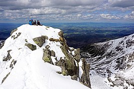
Summits edit
-
 Gerlachovský štít (2,655 metres or 8,711 feet), the highest peak in Slovakia
 -
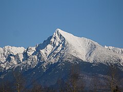 Kriváň (2,495 metres or 8,186 feet), the country's symbol on 1,2 and 5 euro cents
 -
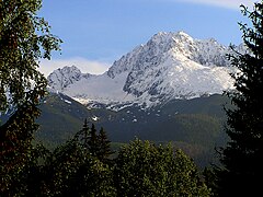
 View from Lomnický štít (2,634 metres or 8,642 feet)
 -
 Skalnaté pleso Observatory (1,751 metres or 5,745 feet)
 -
 Bystrá (2,248 metres or 7,375 feet)
 -
 Kościelec (2,155 metres or 7,070 feet)


Eastern Tatras edit
- Gerlachovský štít - 2655 m (Slovakia)
- Lomnický štít - 2634 m (Slovakia)
- Ľadový štít - 2627 m (Slovakia)
- Pyšný štít - 2621 m (Slovakia)
- Zadný Gerlach - 2616 m (Slovakia)
- Lavínový štít - 2606 m (Slovakia)
- Ľadová kopa - 2602 m (Slovakia)
- Kotlový štít - 2601 m (Slovakia)
- Malý Pyšný štít - 2592 m (Slovakia)
- Kežmarský štít - 2558 m (Slovakia)
- Vysoká - 2547 m (Slovakia)
- Končistá - 2538 m (Slovakia)
- Baranie rohy - 2526 m (Slovakia)
- Dračí štít - 2523 m (Slovakia)
- Ťažký štít - 2520 m (Slovakia)
- Malý Kežmarský štít - 2513 m (Slovakia)
- Rysy - 2503 m, 2499 m (Slovakia/Poland)
- Kriváň - 2495 m (Slovakia)
- Slavkovský štít - 2452 m (Slovakia)
- Batizovský štít - 2448 m (Slovakia)
- Veľký Mengusovský štít (Slovak); Mięguszowiecki Szczyt Wielki (Polish) - 2438 m (Slovakia/Poland)
- Malé Rysy (Slovak); Niżnie Rysy (Polish) - 2430 m (Slovakia/Poland)
- Východná Vysoká - 2429 m (Slovakia)
- Východný Mengusovský štít (Slovak); Mięguszowiecki Szczyt Czarny (Polish) - 2410 m (Slovakia/Poland)
- Prostredný Mengusovský štít (Slovak); Mięguszowiecki Szczyt Pośredni (Polish) - 2393 m (Slovakia/Poland)
- Čubrina (Slovak); Cubryna (Polish) - 2376 m (Slovakia/Poland)
- Svinica (Slovak); Świnica (Polish) - 2301 m (Slovakia/Poland)
- Kozi Wierch - 2291 m (Poland)
- Jahňaci štít - 2230 m (Slovakia)
- Zamarła Turnia - 2179 m (Poland)
- Kościelec - 2155 m (Poland)
- Mnich - 2068 m (Poland)
Western Tatras edit
- Bystrá - 2248 m (Slovakia)
- Jakubina - 2194 m (Slovakia)
- Baranec - 2184 m (Slovakia)
- Baníkov - 2178 m (Slovakia)
- Klin (Slovak); Starorobociański Wierch (Polish) - 2176 m (Slovakia/Poland)
- Pachoľa - 2167 m (Slovakia)
- Hrubá kopa - 2166 m (Slovakia)
- Nižná Bystrá - 2163 m (Slovakia)
- Štrbavy - 2149 m (Slovakia)
- Jalovecký príslop - 2142 m (Slovakia)
- Hrubý vrch (Slovak); Jarząbczy Wierch (Polish) - 2137 m (Slovakia/Poland)
- Tri kopy - 2136 m (Slovakia)
- Veľká Kamenistá (Slovak); Kamienista (Polish) - 2126 m (Slovakia/Poland)
- Krzesanica - 2122 m (Slovakia/Poland) - summit of Czerwone Wierchy / Red Mountains
- Volovec (Slovak); Wołowiec (Polish) - 2064 m (Slovakia/Poland)
- Kasprov vrch (Slovak); Kasprowy Wierch (Polish) - 1987 m (Slovakia/Poland)
- Giewont - 1894 m (Poland)
- Sivý vrch - 1809 m (Slovakia)
Tourism edit
In 1683, an anonymous author published a book of adventures and excursions in the Tatras. It became very popular in Europe and contributed to the growth of tourism in the Tatras. As it later turned out, its author was Daniel Speer, born in Wrocław, who for a time lived in the sub-Tatra region.[citation needed]
A popular tourist destination in Poland is Zakopane but the developed tourist base also includes Kościelisko, Poronin, Biały Dunajec, Bukowina Tatrzańska, Białka Tatrzańska, Murzasichle, Małe Ciche, Ząb, Jurgów, Brzegi.[citation needed]
In Slovakia, the most important tourist base is the city Vysoké Tatry, consisting of three parts: Štrbské Pleso, Starý Smokovec and Tatranská Lomnica.[citation needed]
The Polish "national mountain" (featured prominently in myths and folklore) is Giewont, while the Slovak one is Kriváň.[citation needed]
Trails edit


Orla Perć is considered the most difficult and dangerous mountain trail in the Tatras, a suitable destination only for experienced tourists and climbers. It lies exclusively within the Polish part of the Tatras, was conceived in 1901 by Franciszek Nowicki, a Polish poet and mountain guide, and was built between 1903 and 1906. Over 100 individuals have died on the route since it was established. The path is marked with red signs.[citation needed] The death of Polish philosopher Bronisław Bandrowski is often used by guides as a cautionary tale for tourists. He committed suicide after he was trapped for days on a rocky ledge in one of the trails near Zakopane.[15]
The highest point in the Tatra Mountains that can be freely accessed by a labeled trail is Rysy.[16]
Most of the peaks in the Western Tatras (on both sides of the border), including the main ridge are freely accessible by hiking trails. In the Slovak part of the Eastern Tatras, only seven peaks (out of 48 with prominence of at least 100 m) are accessible by hiking trails (Rysy, Svinica/Świnica, Slavkovský štít, Kriváň, Kôprovský štít, Východná Vysoká, and Jahňací štít). Two of these (Rysy and Svinica/Świnica) are located on the border with Poland and accessible from the Polish side. The rest of the peaks on the Slovak side (including the highest one, Gerlachovský štít) can only be accessed when accompanied by a certified mountain guide. UIAA members can climb them without a certified guide, but not using the normal (easiest) routes (from the III degree of difficulty).[citation needed]
In the Slovak part most of the hiking trails in the Tatras are closed from 1 November to 15 June. Only trails from settlements up to the mountain huts are open. In Poland, the trails are open year-round.[citation needed]
Human engagement edit
In the 18th and 19th centuries, the mountains were used for sheep grazing and mining. Many trees were cut down to make way for humans. Although these activities were stopped, the impact is still visible. Moreover, pollution from the industrialized regions of Kraków in Poland or Ostrava in Czech Republic, as well as casual tourism, cause substantial damage.[17] Volunteers however initiate litter removal events frequently, on both sides of the border.
The Slovak Tatra National Park (Tatranský národný park; TANAP) was founded in 1949 (738 km2, 285 sq mi), and the contiguous Polish Tatra National Park (Tatrzański Park Narodowy) in 1954 (215.56 km2, 83.23 sq mi).[18] The two parks were added jointly to the UNESCO Biosphere Reserve list in 1993.[5]
In 2013, the International Union for Conservation of Nature threatened to cancel the Slovak TANAP's status of a national park because of the large investments (mainly in skiing infrastructure) in the park, which seriously interfere with the landscape and nature.[citation needed]
In popular culture edit
- The theme of the song "Nad Tatrou sa blýska" is that there is a storm in the Tatras. The song was the second part of the dual national anthem of Czechoslovakia from 1918 to its dissolution in 1993, and since became the national anthem of Slovakia.
- Czech composer Vítězslav Novák's 1902 symphonic poem V Tatrách ('In the Tatras', Op.26) was directly inspired by the mountains.
- "A 1930's ski-movie, filmed in Tatras, Poland". nevaasport.com. Archived from the original on 21 June 2007.
- The 1999 film Ravenous was filmed in the Tatra Mountains.[19]
- In 2006, the Bollywood film Fanaa, portraying places in Kashmir, was filmed at Zakopane, mainly because of the risks associated with insurgency in Kashmir, as well due to some similarities in a mountain landscape.[citation needed][20]
- Leo Frankowski mentions the Tatras several times in his science fiction novels in the Conrad Stargard series.
- The Tatra Mountains are the setting of the 2024 Netflix crime drama television series Detective Forst, based on the Forst series by Remigiusz Mróz.[21]
Notable people edit
(Alphabetical by surname)
- Adam Asnyk, poet and dramatist, one of the first members of the Tatra Society
- Klemens Bachleda (1851–1910), Polish mountain guide and mountain rescuer
- Oswald Balzer
- Tytus Chałubiński, founder of the Polish Tatra Society
- Jan Długosz (mountaineer)
- Walery Eljasz-Radzikowski
- Julian Fałat
- Jan Nepomucen Głowacki, considered the father of Polish school of landscape painting, was the first to devote an entire series of works to Tatra Mountains
- Seweryn Goszczyński, Polish Romantic poet who escaped there from the Austrian invader
- Ludwig Greiner, identified Gerlachovský Peak as the summit of the Tatras and Carpathians
- Ruth Hale (alpinist)
- Władysław Hasior
- William Horwood (novelist), whose novel Wolves of Time largely takes place in the Tatra mountains
- Mieczysław Karłowicz
- Jan Kasprowicz
- Kornel Makuszyński
- Franciszek Nowicki
- Władysław Orkan
- Kazimierz Przerwa-Tetmajer
- Daniel Speer, Baroque composer and writer
- Stanisław Staszic
- Mieczysław Szczuka
- Karol Szymanowski
- Göran Wahlenberg
- Stanisław Witkiewicz
- Leon Wyczółkowski
- Władysław Zamoyski
- Mariusz Zaruski
- Ludwik Zejszner
- Stefan Żeromski
Rankings edit
- Polish Tatra National Park is ranked 12th place by CNN[22]
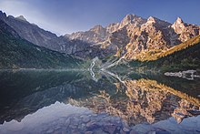
- The Wall Street Journal recognized Morskie Oko as one of the five most beautiful lakes in the world[23]
See also edit
- Mountain Rescue Service (Slovakia)
- Sudetes
- Tatrzańskie Ochotnicze Pogotowie Ratunkowe (Tatra Volunteer Search and Rescue (Poland))
- Tourism in Poland
References edit
- ^ "Polskie Rysy ze zmienioną wysokością na nowej mapie Tatr". Onet Podróże (in Polish). 23 August 2020. Archived from the original on 22 December 2022. Retrieved 9 May 2023.
- ^ Trengove, Mark (July 2005). "Introduction to the Tatras". PeakList: Mountains of the World. Retrieved 1 January 2013.
- ^ a b Strzala, Marek (2012). "Tatra Mountains. Features. Weather. Wildlife". Krakow Info: National Parks. Retrieved 1 January 2013.
- ^ Krupa, Maciek (2012). "The Tatra Mountains and Tatra National Park". Discover Zakopane. BAW Altius. Retrieved 1 January 2013.
- ^ a b "Europe & North America: 297 biosphere reserves in 36 countries". UNESCO: Ecological Sciences for Sustainable Development. Archived from the original on 5 August 2015. Retrieved 31 January 2016.
- ^ a b František, Kele; Lučanský, Milan (2001). Tatry (in Czech). Praha: Knižní klub.
- ^ Machek, Václav (1931). "Tatry". Naše řeč (15): 119–120.
- ^ USA, IBP (3 March 2012). Slovakia Country Study Guide Volume 1 Strategic Information and Developments. Lulu.com. ISBN 978-1-4387-7555-5.
- ^ "Wysokogórskie Obserwatorium Meteorologizne IMGW-PIB". PKL. Archived from the original on 25 March 2019. Retrieved 5 December 2023.
- ^ Vojtek, Martin (31 July 2010). "The dynamics of snow cover in mountainous regions of Slovakia" (PDF). p. 76. Archived (PDF) from the original on 5 December 2023. Retrieved 5 December 2023.
- ^ Slovakia Republic Country: Strategic Information and Developments. United States: International Business Publications USA. 2012. p. 38. ISBN 978-1-4387-7555-5.
- ^ a b Igor J. Zaleski; Tomasz Mączka. "Wiatr halny". Tatrzański Park Narodowy (in Polish). Archived from the original on 9 January 2011.
- ^ USA, IBP (3 March 2012). Slovakia Country Study Guide Volume 1 Strategic Information and Developments. Lulu.com. ISBN 978-1-4387-7555-5.
- ^ Kulczynski (1882). "Xysticus alpicola". Fauna Europaea. 2.4.
- ^ Brożek, Anna; Chybińska, Alicja; Jadacki, Jacek; Woleński, Jan (2015). Tradition of the Lvov-Warsaw School: Ideas and Continuations. Leiden: BRILL. pp. 265, 271. ISBN 978-90-04-31175-6.
- ^ "Zabi Szczyt Wyzni : Climbing, Hiking & Mountaineering: SummitPost". www.summitpost.org. Retrieved 10 October 2022.
- ^ "Multi-scale interactions between disturbances and ecological and socioeconomical changes – case study High Tatra Mts. (Slovakia)" (PDF). lter-europe.net. Retrieved 14 June 2015.
- ^ "Official website of Polish Tatra National Park". www.tpn.pl (in Polish). Archived from the original on 25 February 2011. Retrieved 10 March 2011.
- ^ "Ravenous filming locations". imdb.com.
- ^ Sedia, Giuseppe (11 August 2012). "Bollywood Beats a Path to Krakow". The Krakow Post. Retrieved 24 March 2019.
- ^ Wawrzyn, Marta (21 October 2022). "Detektyw Forst - ruszyły zdjęcia! Co już wiemy o polskim serialu Netfliksa?". Serialowa (in Polish). Retrieved 27 November 2023.
- ^ "Tatrzański Park Narodowy na 12. miejscu w rankingu". CNN (in Polish). onet. Retrieved 11 April 2015.
- ^ Styles, Ruth (22 July 2014). "Great Lakes Around the World". The Wall Street Journal. Retrieved 4 February 2021.
Bibliography edit
External links edit
- "Places to visit Tatras Mountains". travelzenith.com. April 2014. – (available in: ENG)
- "Town of Vysoké Tatry". tatry.sk (in Slovak). Municipal website (available in: ENG, SLV)
- Zakopane – municipal website (available in: POL, ENG)
- TANAP – Slovak Tatra National Park (available in: SLV, ENG, POL)
- TPN – Polish Tatra National Park (available in POL only)
- Commercial tourism-oriented websites
- The High Tatras - Accommodation and Tourism (available in: SLV, CZE, POL, ENG, GER)
- Vysoké Tatry, Slovakia (available in: ENG, GER, SLV, POL)
- Tatry - The smallest mountains in the biggest detail. (available in: ENG, CZE)
- Tatra auf Travelia.sk
- Mountaineering
- Tatra Volunteer Rescue Service (available in POL only)
- Mountaineering in Tatra Mountains (practical info about climbing in Tatras)
- Photography