


Summary
Tauere Atoll or Taouere, also known as Te Putua, is a small atoll of the central Tuamotu Archipelago in French Polynesia. It is located 85 kilometres (53 miles) northwest of Hao Atoll's westernmost point.[2]
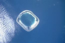 NASA picture of Tauere Atoll | |
 Tauere | |
| Geography | |
|---|---|
| Location | Pacific Ocean |
| Coordinates | 17°22′S 141°28′W / 17.367°S 141.467°W |
| Archipelago | Tuamotus |
| Area | 60 km2 (23 sq mi) (lagoon) 3.9 km2 (1.5 sq mi) (above water) |
| Length | 7.5 km (4.66 mi) |
| Administration | |
France | |
| Overseas collectivity | French Polynesia |
| Administrative subdivision | Tuamotus |
| Commune | Hao |
| Demographics | |
| Population | 3[1] (2012) |

Tauere Atoll is squarish in shape. It measures 7.5 kilometres (4.7 miles) across. The islands are located on its northern and eastern sides. Its lagoon is not connected to the ocean by a pass, which makes this small atoll quite inaccessible.
Tauere has only 3 inhabitants. In 2007 it had 7 inhabitants.[3]
History edit
The first European recorded sight of the atoll was by the Spanish expedition of Pedro Fernandez de Quirós on 12 February 1606. They charted it as La Decena.[4] Tauere was again sighted by Spanish navigator Domingo de Boenechea on October 28, 1772 on the ship Aguila.[5] He sailed from Callao on September 26, 1772, to establish a colony on Tahiti.[6] He called this atoll San Simon y Judas.[7] Hence this atoll appears in some maps as St. Simon.[8]
Administration edit
Administratively Tauere belongs to the commune of Amanu (Main village: Ikitake) which includes the atolls of Rekareka (uninhabited) and Tauere. The Amanu commune is associated with the Hao commune.
References edit
- ^ "Population". Institut de la statistique de la Polynésie française. Retrieved 10 October 2014.
- ^ "Tauere". Ocean Dots. 11 July 2011. Archived from the original on 23 December 2010. Retrieved 24 May 2019.
- ^ Bowermaster, Jon (18 February 2007). "The Fragile Paradise That Tahiti Used to Be". NY Times. The New York Times Company. p. TR8. Retrieved 24 May 2019.
- ^ Kelly, Celsus, O.F.M. La Austrialia del Espiritu Santo. The Journal of Fray Martín de Munilla O.F.M. and other documents relating to the Voyage of Pedro Fernández de Quirós to the South Sea (1605-1606) and the Franciscan Missionary Plan (1617-1627) Cambridge, 1966, p.313.
- ^ Salmond, Anne (2010). Aphrodite's Island. Berkeley: University of California Press. pp. 241. ISBN 9780520261143.
- ^ Buck, Peter H. (1953). "Spanish Voyages of the Eighteenth Century". In Charlot, Jean (ed.). Explorers of the Pacific: European and American Discoveries in Polynesia. Victoria University of Wellington. p. 60. Retrieved 24 May 2019 – via New Zealand Electronic Text Collection.
- ^ Mellén Blanco, Francisco (1992). "Un diario inédito sobre la presencia española en Tahití (1774-1775)". Revista Española del Pacífico (in Spanish) (2): 109–182. Retrieved 24 May 2019 – via Cervantes Virtual.
- ^ Young, J. L. (December 1899). "NAMES OF THE PAUMOTU ISLANDS, WITH THE OLD NAMES SO FAR AS THEY ARE KNOWN". The Journal of the Polynesian Society. 8: 264–268. Retrieved 24 May 2019.
- Population data
External links edit
- Atoll list (in French)