


Summary
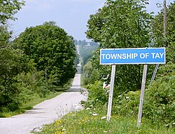
Tay is a township in Central Ontario, Canada, located in Simcoe County in the southern Georgian Bay region. The township was named in 1822 after a pet dog of Lady Sarah Maitland (1792–1873), wife of Sir Peregrine Maitland, Lieutenant Governor of Upper Canada. Two other adjoining townships were also named for her pet dogs, Tiny and Flos (now Springwater Township).[3]
Tay | |
|---|---|
| Township of Tay | |
 | |
 Tay  Tay | |
| Coordinates: 44°43′N 79°46′W / 44.717°N 79.767°W | |
| Country | |
| Province | |
| County | Simcoe |
| Incorporated | 1994 |
| Government | |
| • Mayor | Ted Walker |
| • MPs | Bruce Stanton |
| • MPPs | Jill Dunlop |
| Area | |
| • Total | 139.07 km2 (53.70 sq mi) |
| Population (2016)[2] | |
| • Total | 10,033 |
| • Density | 72.1/km2 (187/sq mi) |
| Time zone | UTC-5 (Eastern (EST)) |
| • Summer (DST) | UTC-4 (EDT) |
| Area code(s) | 705, 249 |
| Website | www.tay.ca |
History edit
The current territory of Tay was home to the Wendat towns of Teanaostataé (St. Louis), and Taenhatentaron (St. Ignace). Together with the nearby town of Teanaustayé (St. Joseph) in nearby Hillsdale they were destroyed by the Iroquois (Haudenosaunee) in 1648–1649. During this warfare, the Jesuits Jean de Brébeuf and Gabriel Lalemant were killed at Taenhatentaron.[4]
In 1994, under countywide municipal restructuring, the Villages of Port McNicoll and Victoria Harbour were amalgamated with Tay.
Communities edit
The township comprises the villages and rural hamlets of Ebenezer, Elliots Corners, Melduf, Mertzs Corners, Ogden's Beach, Old Fort, Paradise Point, Port McNicoll, Riverside, Sturgeon Bay, Triple Bay Park, Vasey, Victoria Harbour, Waubaushene and Waverley.
-
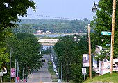 Port McNicoll
 -
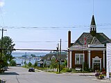 Victoria Harbour


Demographics edit
In the 2021 Census of Population conducted by Statistics Canada, Tay had a population of 11,091 living in 4,535 of its 5,301 total private dwellings, a change of 10.5% from its 2016 population of 10,033. With a land area of 137.86 km2 (53.23 sq mi), it had a population density of 80.5/km2 (208.4/sq mi) in 2021.[5]
| 2016 | 2011 | |
|---|---|---|
| Population | 10,033 (+3.1% from 2011) | 9,736 (-0.1% from 2006) |
| Land area | 139.07 km2 (53.70 sq mi) | 139.00 km2 (53.67 sq mi) |
| Population density | 72.1/km2 (187/sq mi) | 70.0/km2 (181/sq mi) |
| Median age | 48.7 (M: 47.9, F: 49.4) | |
| Private dwellings | 4,931 (total) | 5,049 (total) |
| Median household income | $65,190 |
Notable people edit
- Amos Arbour - NHL, NHA hockey player, member of original Montreal Canadiens hockey club.
- Wayne Middaugh - World Champion Curling Skip
- Sherry Middaugh - Canadian Curling Skip
- Keith Waples - Famed driver of Standardbred horses and inductee into Canada's Sports Hall of Fame
See also edit
References edit
- ^ "Tay census profile". 2011 Census of Population. Statistics Canada. Retrieved 2012-02-15.
- ^ "Census Profile, 2016 Census: Tay, Township". Statistics Canada. Retrieved July 3, 2019.
- ^ Rayburn, Alan (1997), Place Names of Ontario (University of Toronto Press), Toronto-Buffalo-London, ISBN 0-8020-7207-0), pp.345
- ^ "Culmination of Iroquoian Wars: Sainte Marie I Destruction". Digital Museums Canada. Retrieved November 19, 2023.
- ^ "Population and dwelling counts: Canada, provinces and territories, census divisions and census subdivisions (municipalities), Ontario". Statistics Canada. February 9, 2022. Retrieved April 2, 2022.
- ^ "2016 Community Profiles". 2016 Canadian Census. Statistics Canada. August 12, 2021. Retrieved 2017-08-15.
- ^ "2011 Community Profiles". 2011 Canadian Census. Statistics Canada. March 21, 2019. Retrieved 2012-02-15.
- ^ "2006 Community Profiles". 2006 Canadian Census. Statistics Canada. August 20, 2019.
- ^ "2001 Community Profiles". 2001 Canadian Census. Statistics Canada. July 18, 2021.
External links edit
- Official website
- Ontario's Historical Plaques: Saint-Louis
- Mission of St. Ignace II National Historic Site of Canada