


Summary
Teddington is a very small community on Banks Peninsula at the head of Lyttelton Harbour / Whakaraupō. It sits on the junction of the road to Gebbies Pass and the road from Purau to Christchurch.
Teddington | |
|---|---|
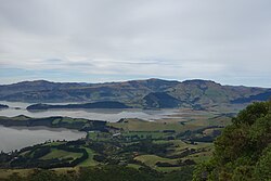 Looking northeast, with Head of the Bay in the lower left of the picture and Te Wharae / Charteris Bay in the centre | |
 | |
| Coordinates: 43°40′06.24″S 172°39′40.81″E / 43.6684000°S 172.6613361°E | |
| Country | New Zealand |
| Region | Canterbury |
| Local authority | Christchurch City Council |
| Ward | Banks Peninsula |
| Community | Te Pātaka o Rākaihautū Banks Peninsula |
| Electorates |
|
| Government | |
| • Territorial Authority | Christchurch City Council |
| • Regional council | Environment Canterbury |
| • Mayor of Christchurch | Phil Mauger |
| • Banks Peninsula MP | Vanessa Weenink |
| • Te Tai Tonga MP | Tākuta Ferris |
| Area | |
| • Total | 47.42 km2 (18.31 sq mi) |
| Population (June 2023)[2] | |
| • Total | 270 |
| • Density | 5.7/km2 (15/sq mi) |
| Time zone | UTC+12 (NZST) |
| • Summer (DST) | UTC+13 (NZDT) |
It dates back to the early settlers of Christchurch[3] but is now reduced to a pub and a restored working blacksmith's forge.[4]
Tsunami edit
An earthquake near Chile on 23 May 1960 caused a tsunami which crossed the Pacific to hit New Zealand. The tsunami was funnelled up Lyttelton Harbour and flooded low-lying farmland and the Wheatsheaf Tavern in Teddington. [5] A similar event occurred in 2010 following an earthquake in Chile with three waves that were greater than two metres high inundating the head of the harbour around Teddington.[6]
An earlier tsunami occurred in 1868 following an earthquake off the coast of Peru. This caused an eight foot high wave to be funneled up Lyttelton Harbour towards Teddington.[7]
Demographics edit
The Teddington statistical area, which extends from Governors Bay almost to Purau[8] and includes Ōtamahua / Quail Island, covers 47.42 km2 (18.31 sq mi).[1] It had an estimated population of 270 as of June 2023,[2] with a population density of 5.7 people per km2.
| Year | Pop. | ±% p.a. |
|---|---|---|
| 2006 | 207 | — |
| 2013 | 192 | −1.07% |
| 2018 | 234 | +4.04% |
| Source: [9] | ||

Before the 2023 census, the statistical area had a smaller boundary, covering 46.15 km2 (17.82 sq mi).[1] Using that boundary, Teddington had a population of 234 at the 2018 New Zealand census, an increase of 42 people (21.9%) since the 2013 census, and an increase of 27 people (13.0%) since the 2006 census. There were 87 households, comprising 117 males and 114 females, giving a sex ratio of 1.03 males per female. The median age was 46.5 years (compared with 37.4 years nationally), with 36 people (15.4%) aged under 15 years, 39 (16.7%) aged 15 to 29, 114 (48.7%) aged 30 to 64, and 42 (17.9%) aged 65 or older.
Ethnicities were 97.4% European/Pākehā, 5.1% Māori, and 2.6% Pasifika. People may identify with more than one ethnicity.
The percentage of people born overseas was 25.6, compared with 27.1% nationally.
Although some people chose not to answer the census's question about religious affiliation, 57.7% had no religion, 33.3% were Christian, 1.3% were Buddhist and 1.3% had other religions.
Of those at least 15 years old, 75 (37.9%) people had a bachelor's or higher degree, and 18 (9.1%) people had no formal qualifications. The median income was $39,300, compared with $31,800 nationally. 48 people (24.2%) earned over $70,000 compared to 17.2% nationally. The employment status of those at least 15 was that 105 (53.0%) people were employed full-time, 33 (16.7%) were part-time, and 3 (1.5%) were unemployed.[9]
St Peter's Anglican church edit

St Peter's church is an Anglican church that was designed by the architect Benjamin Mountfort. It was opened in 1871, and the church was consecrated in 1885. The church can accommodate up to 80 parishioners. The church is built out of kauri and the floor is built out of matai.[10][11]
References edit
- ^ a b c "ArcGIS Web Application". statsnz.maps.arcgis.com. Retrieved 14 October 2021.
- ^ a b "Population estimate tables - NZ.Stat". Statistics New Zealand. Retrieved 25 October 2023.
- ^ "Teddington". Victoria University of Wellington. 2008. Retrieved 7 November 2019.
- ^ "Unexpected Places -The blacksmith at Teddington". Stuff.co.nz. 8 April 2018. Retrieved 7 November 2019.
- ^ "Natural Hazards: Tsunami | East Coast LAB | Life at the Boundary". www.eastcoastlab.org.nz. Retrieved 17 October 2020.
- ^ "Tsunami are frequent visitors to New Zealand shores". Stuff. 12 July 2019. Retrieved 17 October 2020.
- ^ "8 Foot Tsunami Hits Banks Peninsula – 15th August 1868". Discover The Delights Of Peeling Back History. 14 August 1868. Retrieved 17 October 2020.
- ^ "Geographic boundary viewer Teddington". Stats NZ. Retrieved 19 April 2024.
- ^ a b "Statistical area 1 dataset for 2018 Census". Statistics New Zealand. March 2020. Teddington (332800). 2018 Census place summary: Teddington
- ^ "St Peter's Church, Teddington—Mt Herbert Parish (Banks Peninsula) – Anglican Life". www.anglicanlife.org.nz. Retrieved 29 June 2023.
- ^ "Teddington". Mount Herbert Parish. 18 September 2009. Retrieved 29 June 2023.