


Summary
Tehran County (Persian: شهرستان تهران) is in Tehran province of Iran. Its capital is the city of Tehran.[3]
Tehran County
Persian: شهرستان تهران | |
|---|---|
County | |
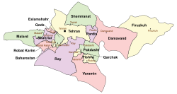 Location of Tehran County in Tehran province (top, yellow) | |
 Location of Tehran province in Iran | |
| Coordinates: 35°45′N 51°25′E / 35.750°N 51.417°E[1] | |
| Country | Iran |
| Province | Tehran |
| Capital | Tehran |
| Districts | Central, Aftab, Kan |
| Area | |
| • Total | 1,300.3 km2 (502.0 sq mi) |
| Population (2016)[2] | |
| • Total | 8,737,510 |
| • Density | 6,700/km2 (17,000/sq mi) |
| Time zone | UTC+3:30 (IRST) |
| Tehran County can be found at GEOnet Names Server, at this link, by opening the Advanced Search box, entering "9206102" in the "Unique Feature Id" form, and clicking on "Search Database". | |
| Year | Pop. | ±% |
|---|---|---|
| 1940 | 540,087 | — |
| 1956 | 1,512,082 | +180.0% |
| 1966 | 2,719,730 | +79.9% |
| 2006 | 7,892,340 | +190.2% |
| 2011 | 8,189,791 | +3.8% |
| 2016 | 8,737,510 | +6.7% |
| amar.org.ir Excluding areas part of the county during previous censuses | ||
At the 2006 census, the county's population was 7,882,843 in 2,313,002 households.[4] The following census in 2011 counted 8,293,140 people in 2,637,704 households.[5] At the 2016 census, the county's population was 8,737,510 in 2,924,208 households,[2] by which time most of the Central District outside the city of Tehran had been separated from the county in the establishment of Pardis County.[6] Greater Tehran is situated mostly in Tehran County. It is the most populous county in Iran.
Administrative divisions edit
The population history and structural changes of Tehran County's administrative divisions over three consecutive censuses are shown in the following table. The latest census shows three districts, four rural districts, and one city.[2]
| Administrative Divisions | 2006[4] | 2011[5] | 2016[2] |
|---|---|---|---|
| Central District | 7,796,431 | 8,262,262 | 8,699,284 |
| Siyahrud RD1 | 16,837 | 17,503 | 5,578 |
| Bumahen (city)2 | 43,004 | 53,451 | |
| Pardis (city)2 | 25,360 | 37,257 | |
| Tehran (city) | 7,711,230 | 8,154,051 | 8,693,706 |
| Aftab District | 22,898 | 28,402 | 32,630 |
| Aftab RD | 14,847 | 15,117 | 12,626 |
| Khalazir RD | 8,051 | 13,285 | 20,004 |
| Kan District | 63,514 | 2,469 | 5,013 |
| Sulqan RD | 63,514 | 2,469 | 5,013 |
| Total | 7,882,843 | 8,293,140 | 8,737,510 |
| RD: Rural District 1Most became a part of Pardis County[6] 2Became a part of Pardis County[6] | |||
References edit
- ^ OpenStreetMap contributors (21 March 2024). "Tehran County" (Map). OpenStreetMap. Retrieved 21 March 2024.
- ^ a b c d "Census of the Islamic Republic of Iran, 1395 (2016)". AMAR (in Persian). The Statistical Center of Iran. p. 23. Archived from the original (Excel) on 12 December 2021. Retrieved 19 December 2022.
- ^ Habibi, Hassan (21 June 1369). "Approval of the organization and chain of citizenship of the elements and units of the national divisions of Tehran province centered on the city of Tehran". Islamic Parliament Research Center (in Persian). Ministry of Interior, Political-Defense Commission of the Government Board. Archived from the original on 30 November 2014. Retrieved 16 December 2023.
- ^ a b "Census of the Islamic Republic of Iran, 1385 (2006)". AMAR (in Persian). The Statistical Center of Iran. p. 23. Archived from the original (Excel) on 20 September 2011. Retrieved 25 September 2022.
- ^ a b "Census of the Islamic Republic of Iran, 1390 (2011)". Syracuse University (in Persian). The Statistical Center of Iran. p. 23. Archived from the original (Excel) on 20 January 2023. Retrieved 19 December 2022.
- ^ a b c Rahimi, Mohammad Reza (29 September 2013). "Approval letter regarding country divisions in Tehran province". Research Center of the System of Laws of the Islamic Council of the Farabi Library (in Persian). Ministry of Interior, Council of Ministers. Archived from the original on 1 June 2013. Retrieved 23 November 2023.