


Summary
Terra Sabaea is a large area on Mars. Its coordinates are 2°N 42°E / 2°N 42°E and it covers 4,700 kilometres (2,900 mi) at its broadest extent. It was named in 1979 after a classic albedo feature on the planet. Terra Sabaea is fairly large and parts of it are found in five quadrangles: Arabia quadrangle, Syrtis Major quadrangle, Iapygia quadrangle, Ismenius Lacus quadrangle, and Sinus Sabaeus quadrangle.

Glaciers edit
Some landscapes look just like glaciers moving out of mountain valleys on Earth. Some have a hollowed-out appearance, looking like a glacier after almost all the ice has disappeared. What is left are the moraines—the dirt and debris carried by the glacier. The center is hollowed out because the ice is mostly gone.[1] These supposed alpine glaciers have been called glacier-like forms (GLF) or glacier-like flows (GLF).[2] Glacier-like forms are a later and maybe more accurate term because we cannot be sure the structure is currently moving.[3] Another, more general term sometimes seen in the literature is viscous flow features (VFF).[3]
A variety of other features on the surface have also been interpreted as directly linked to flowing ice, such as fretted terrain,[4] lineated valley fill,[5][6] concentric crater fill,[7][8] and arcuate ridges.[9] A variety of surface textures seen in imagery of the midlatitudes and polar regions are also thought to be linked to sublimation of glacial ice.[8][10]
The pictures below show features believed to be glaciers—some may still contain ice; in others the ice has probably largely disappeared. Since ice may be present under just a few meters of debris, these places could be used to supply future Martian settlers with water.
-
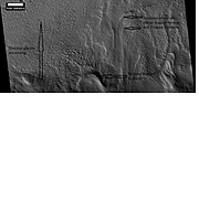
 Romer Lake's Elephant Foot Glacier in the Earth's Arctic, as seen by Landsat 8. This picture shows several glaciers that have the same shape as many features on Mars that are believed to also be glaciers.
 -
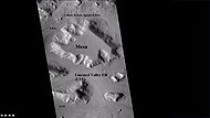
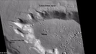
 Mesa in Ismenius Lacus quadrangle, as seen by CTX. Mesa has several glaciers eroding it. One of the glaciers is seen in greater detail in the next two images from HiRISE.
 -
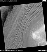
 Glacier as seen by HiRISE under the HiWish program. Area in rectangle is enlarged in the next photo. Zone of accumulation of snow at the top. Glacier is moving down valley, then spreading out on plain. Evidence for flow comes from the many lines on surface. Location is in Protonilus Mensae in Ismenius Lacus quadrangle.
 -
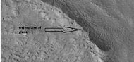
 Enlargement of area in rectangle of the previous image. On Earth the ridge would be called the terminal moraine of an alpine glacier. Picture taken with HiRISE under the HiWish program.
 -
 Remains of glaciers, as seen by HiRISE under the HiWish program.
 -
 End of a glacier, as seen by HiRISE under HiWish program. Surface to the right of the end moraine exhibits patterned ground which is common where ground water has frozen.
 -
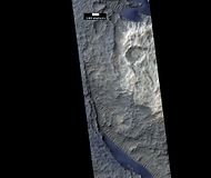
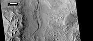
 Wide CTX view showing mesa and buttes with lobate debris aprons and lineated valley fill around them. Location is Ismenius Lacus quadrangle.
 -
 Close-up of lineated valley fill (LVF), as seen by HiRISE under HiWish program. Note: this is an enlargement of the previous CTX image.


-
 Wide view of Lineated Valley Fill, as seen by HiRISE under HiWish program Location is Ismenius Lacus quadrangle.
 -
 Enlarged view of brain terrain on the surface of Lineated Valley Fill, as seen by HiRISE under HiWish program Location is Ismenius Lacus quadrangle.
 -
 Close, color view of Lineated Valley Fill, as seen by HiRISE under HiWish program Location is Ismenius Lacus quadrangle.


Dunes edit
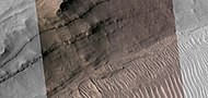
When there are perfect conditions for producing sand dunes, steady wind in one direction and just enough sand, a barchan sand dune forms. Barchans have a gentle slope on the wind side and a much steeper slope on the lee side where horns or a notch often forms.[11] The whole dune may appear to move with the wind. Observing dunes on Mars can tell us how strong the winds are, as well as their direction. If pictures are taken at regular intervals, one may see changes in the dunes or possibly in ripples on the dune’s surface. On Mars dunes are often dark in color because they were formed from the common, volcanic rock basalt. In the dry environment, dark minerals in basalt, like olivine and pyroxene, do not break down as they do on Earth. Although rare, some dark sand is found on Hawaii which also has many volcanoes discharging basalt. Barchan is a Russian term because this type of dune was first seen in the desert regions of Turkistan.[12] Some of the wind on Mars is created when the dry ice at the poles is heated in the spring. At that time, the solid carbon dioxide (dry ice) sublimates or changes directly to a gas and rushes away at high speeds. Each Martian year 30% of the carbon dioxide in the atmosphere freezes out and covers the pole that is experiencing winter, so there is a great potential for strong winds.[13] Some places in Terra Sabaea show dunes, as in the images below.
-
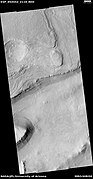
 Dunes in Schaeberle (Martian crater), as seen by HiRISE under the HiWish program.
 -
 Dunes and craters, as seen by HiRISE under HiWish program Some of the dunes are barchans.


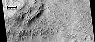
Erosional features in Terra Sabaea edit
-
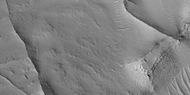
 Eroding mesa in Syrtis Major. It would be rough to walk across this feature. Image was taken with Mars Global Surveyor, under the MOC Public Targeting Program.
 -
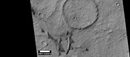
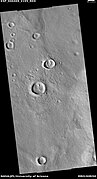
 Close-up of crater deposit that shows both impact craters and pit craters caused by collapse. Image taken by HiRISE under the HiWish program.


Concentric crater fill edit
A concentric crater fill is a landform where the floor of a crater is mostly covered with a large number of parallel ridges.[14] It is common in the mid-latitudes of Mars,[15][16] and is widely believed to be caused by glacial movement.[17][18]
-
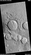
 Crater with concentric crater fill, as seen by CTX (on Mars Reconnaissance Orbiter). Location is Casius quadrangle.
 -
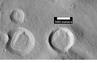
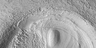
 Well-developed hollows of concentric crater fill, as seen by HiRISE under the HiWish program.
 -
 Close-up that shows cracks containing pits on the floor of a crater containing concentric crater fill, as seen by HiRISE under HiWish program.


Layers in craters edit
Layers along slopes, especially along crater walls are believed to be the remains of a once wide spread material that has mostly been eroded away.[19]
-
 Layers in craters, as seen by HiRISE under the HiWish program. Area was probably covered over by these layers; the layers have now eroded away except for the protected interior of craters.
 -
 Layers in craters, as seen by HiRISE under HiWish program
 -
 Layers in craters, as seen by HiRISE under HiWish program
 -
 Close view of layers in craters, as seen by HiRISE under HiWish program Note: this is an enlargement of the previous image.


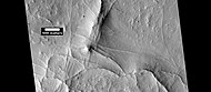
Layers edit
Many places on Mars show rocks arranged in layers. Rock can form layers in a variety of ways. Volcanoes, wind, or water can produce layers.[20] Groundwater may have been involved in the formation of layers in some places.
,
-
 Rock layers in Flammarion Crater, as seen by HiRISE under HiWish program.
 -
 Layers, as seen by HiRISE under HiWish program.


-
 Wide view of layers, as seen by HiRISE under HiWish program
 -
 Close view of layers, as seen by HiRISE under HiWish program
 -
 Close view of layers, as seen by HiRISE under HiWish program A ridge cuts across the layers at a right angle.
 -
 Close view of layers, as seen by HiRISE under HiWish program Part of picture is in color. A ridge cuts across the layers at a right angle.


Linear Ridge Networks edit
Linear ridge networks are found in various places on Mars in and around craters.[21] Ridges often appear as mostly straight segments that intersect in a lattice-like manner. They are hundreds of meters long, tens of meters high, and several meters wide. It is thought that impacts created fractures in the surface, these fractures later acted as channels for fluids. Fluids cemented the structures. With the passage of time, surrounding material was eroded away, thereby leaving hard ridges behind. Since the ridges occur in locations with clay, these formations could serve as a marker for clay which requires water for its formation.[22][23][24]
-
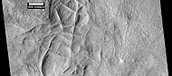 Network of ridges, as seen by HiRISE under HiWish program Ridges may be formed in various ways.
 -
 Color, close-up of ridges seen in previous image, as seen by HiRISE under HiWish program
 -
 More ridges from the same place as the previous two images, as seen by HiRISE under HiWish program
 -
 Linear ridge network, as seen by HiRISE under HiWish program
 -
 Close-up and color image of previous image of linear ridge network, as seen by HiRISe under HiWish program
 -
 More linear ridge networks from same location as previous two images, as seen by HiRISE under HiWish program


-
 Wide view of network of ridges, as seen by HiRISE under HiWish program Portions of this image are enlarged in following images.
 -
 Close view of network of ridges, as seen by HiRISE under HiWish program This is an enlargement of a previous image.
 -
 Close view of network of ridges, as seen by HiRISE under HiWish program This is an enlargement of a previous image. Box shows the size of a football field.
 -
 Close view of network of ridges, as seen by HiRISE under HiWish program This is an enlargement of a previous image.
 -
 Close view of ridges, as seen by HiRISE under HiWish program This is an enlargement of a previous image. A small mesa in the image displays layers.
 -
 Close, color view of network of ridges, as seen by HiRISE under HiWish program This is an enlargement of a previous image.


Other features edit
-
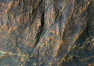 Banded bedrock in Terra Sabaea, in the ancient highlands north of the Hellas basin. The image is about a kilometer wide. Colors are enhanced.
 -
 Wide CTX view of mesa showing lobate debris apron (LDA) and lineated valley fill. Both are believed to be debris-covered glaciers.
 -
 Brain terrain, as seen by HiRISE under HiWish program
 -
 Close-up of lobate debris apron from the previous CTX image of a mesa. Image shows open-cell brain terrain and closed-cell brain terrain, which is more common. Open-cell brain terrain is thought to hold a core of ice. Image is from HiRISE under HiWish program.


-
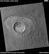 Impact crater that may have formed in ice-rich ground, as seen by HiRISE under HiWish program
 -
 Impact crater that may have formed in ice-rich ground, as seen by HiRISE under HiWish program Note that the ejecta seems lower than the surroundings. The hot ejecta may have caused some of the ice to go away; thus lowering the level of the ejecta.


Interactive Mars map edit

See also edit
References edit
- ^ Milliken, R., J. Mustard, D. Goldsby. 2003. Viscous flow features on the surface of Mars: Observations from high-resolution Mars Orbiter Camera (MOC) images. J. Geophys. Res. 108. doi:10.1029/2002JE002005.
- ^ Arfstrom, J and W. Hartmann. 2005. Martian flow features, moraine-like ridges, and gullies: Terrestrial analogs and interrelationships. Icarus 174, 321-335.
- ^ a b Hubbard B., R. Milliken, J. Kargel, A. Limaye, C. Souness. 2011. Geomorphological characterisation and interpretation of a mid-latitude glacier-like form: Hellas Planitia, Mars Icarus 211, 330–346
- ^ Lucchitta, Baerbel K. "Ice and debris in the fretted terrain, Mars." Journal of Geophysical Research: Solid Earth (1978–2012) 89.S02 (1984): B409-B418.
- ^ G.A. Morgan, J.W. Head, D.R. Marchant Lineated valley fill (LVF) and lobate debris aprons (LDA) in the Deuteronilus Mensae northern dichotomy boundary region, Mars: Constraints on the extent, age and episodicity of Amazonian glacial events Icarus, 202 (2009), pp. 22–38
- ^ D.M.H. Baker, J.W. Head, D.R. Marchant Flow patterns of lobate debris aprons and lineated valley fill north of Ismeniae Fossae, Mars: Evidence for extensive mid-latitude glaciation in the Late Amazonian Icarus, 207 (2010), pp. 186–209
- ^ Milliken, R. E., J. F. Mustard, and D. L. Goldsby. "Viscous flow features on the surface of Mars: Observations from high-resolution Mars Orbiter Camera (MOC) images." Journal of Geophysical Research 108.E6 (2003): 5057.
- ^ a b Levy, Joseph S., James W. Head, and David R. Marchant. "Concentric crater fill in Utopia Planitia: History and interaction between glacial “brain terrain” and periglacial mantle processes." Icarus 202.2 (2009): 462-476. Levy, Joseph S., James W. Head, and David R. Marchant. "Concentric crater fill in Utopia Planitia: History and interaction between glacial “brain terrain” and periglacial mantle processes." Icarus 202.2 (2009): 462-476.
- ^ J. Arfstrom, W.K. Hartmann Martian flow features, moraine-like ridges, and gullies: Terrestrial analogs and interrelationships Icarus, 174 (2005), pp. 321–335
- ^ Hubbard, Bryn, et al. "Geomorphological characterisation and interpretation of a mid-latitude glacier-like form: Hellas Planitia, Mars." Icarus 211.1 (2011): 330-346.
- ^ Pye, Kenneth; Haim Tsoar (2008). Aeolian Sand and Sand Dunes. Springer. p. 138. ISBN 9783540859109.
- ^ "Barchan - sand dune". britannica.com. Retrieved 4 April 2018.
- ^ Mellon, J. T.; Feldman, W. C.; Prettyman, T. H. (2003). "The presence and stability of ground ice in the southern hemisphere of Mars". Icarus. 169 (2): 324–340. Bibcode:2004Icar..169..324M. doi:10.1016/j.icarus.2003.10.022.
- ^ "HiRISE |". hiroc.lpl.arizona.edu. Archived from the original on 2011-07-16.
- ^ Dickson, J. et al. 2009. Kilometer-thick ice accumulation and glaciation in the northern mid-latitudes of Mars: Evidence for crater-filling events in the Late Amazonian at the Phlegra Montes. Earth and Planetary Science Letters.
- ^ "HiRISE - Concentric Crater Fill in the Northern Plains (PSP_001926_2185)". hirise.lpl.arizona.edu. Retrieved 4 April 2018.
- ^ Head, J. et al. 2006. Extensive valley glacier deposits in the northern mid-latitudes of Mars: Evidence for late Amazonian obliquity-driven climate change. Earth Planet. Sci Lett: 241. 663-671.
- ^ Levy, J. et al. 2007.
- ^ Carr, M. 2001. Mars Global Surveyor observations of martian fretted terrain. J. Geophys. Res. 106, 23571-23593.
- ^ "HiRISE | High Resolution Imaging Science Experiment". Hirise.lpl.arizona.edu?psp_008437_1750. Retrieved 2012-08-04.
- ^ Head, J., J. Mustard. 2006. Breccia dikes and crater-related faults in impact craters on Mars: Erosion and exposure on the floor of a crater 75 km in diameter at the dichotomy boundary, Meteorit. Planet Science: 41, 1675-1690.
- ^ Mangold et al. 2007. Mineralogy of the Nili Fossae region with OMEGA/Mars Express data: 2. Aqueous alteration of the crust. J. Geophys. Res., 112, doi:10.1029/2006JE002835.
- ^ Mustard et al., 2007. Mineralogy of the Nili Fossae region with OMEGA/Mars Express data: 1. Ancient impact melt in the Isidis Basin and implications for the transition from the Noachian to Hesperian, J. Geophys. Res., 112.
- ^ Mustard et al., 2009. Composition, Morphology, and Stratigraphy of Noachian Crust around the Isidis Basin, J. Geophys. Res., 114, doi:10.1029/2009JE003349.
Recommended reading edit
- Grotzinger, J. and R. Milliken (eds.). 2012. Sedimentary Geology of Mars. SEPM.
- Lorenz, R. 2014. The Dune Whisperers. The Planetary Report: 34, 1, 8-14
- Lorenz, R., J. Zimbelman. 2014. Dune Worlds: How Windblown Sand Shapes Planetary Landscapes. Springer Praxis Books / Geophysical Sciences.
External links edit
- Martian Ice - Jim Secosky - 16th Annual International Mars Society Convention