


Summary
Texas is a rural town and locality in the Goondiwindi Region of Queensland, Australia.[3][4] It is on the Queensland border with New South Wales.[5] In the 2021 census, the locality of Texas had a population of 790 people.[1]
| Texas Queensland | |||||||||||||||
|---|---|---|---|---|---|---|---|---|---|---|---|---|---|---|---|
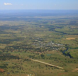 Aerial view of Texas, looking south with the aerodrome runway in the foreground, 2010 | |||||||||||||||
 Texas | |||||||||||||||
| Coordinates | 28°51′31″S 151°09′56″E / 28.8586°S 151.1655°E | ||||||||||||||
| Population | 790 (2021 census)[1] | ||||||||||||||
| • Density | 7.54/km2 (19.52/sq mi) | ||||||||||||||
| Established | 1840s | ||||||||||||||
| Postcode(s) | 4385 | ||||||||||||||
| Elevation | 297 m (974 ft)[2] | ||||||||||||||
| Area | 104.8 km2 (40.5 sq mi) | ||||||||||||||
| Time zone | AEST (UTC+10:00) | ||||||||||||||
| Location |
| ||||||||||||||
| LGA(s) | Goondiwindi Region | ||||||||||||||
| State electorate(s) | Southern Downs | ||||||||||||||
| Federal division(s) | Maranoa | ||||||||||||||
| |||||||||||||||
| |||||||||||||||
History edit
Bigambul (also known as Bigambal, Bigumbil, Pikambul, Pikumbul) is an Australian Aboriginal language spoken by the Bigambul people. The Bigambul language region includes the landscape within the local government boundaries of the Goondiwindi Regional Council, including the towns of Goondiwindi, Yelarbon and Texas extending north towards Moonie and Millmerran.[6]
Texas sits on Bigambul land, the Indigenous people of the region who inhabited the area for thousands of years prior to colonisation in the 1840s.[7]
Texas, at one time, relied on its importance of grazing. It was settled in 1842 and was named after the largest nearby landholding in the area, known as Texas Station.
The origin of the town's name is generally regarded as a reference to a territorial dispute. The land in the area was first settled by the McDougall brothers, who found squatters there on returning from the goldfields. Once their legal right to the land was recognised, they named their property in honour of the dispute between the United States and Mexico over territory in Texas.[3]
Texas Provisional School opened on 1 March 1887. On 1 January 1900, it became Texas State School.[8][9]
Land in Texas was open for selection on 17 April 1877; 140 square miles (360 km2) were available.[10]

Texas was connected by the Texas railway line from Inglewood in November 1930 with the town being served by the Texas railway station (28°51′24″S 151°10′20″E / 28.8568°S 151.1722°E).[11] The line was closed in 1994, but officially remains operational. However, the station is officially abandoned.[12]

Up until about 1986, tobacco farming was an important industry in the area and many Italian families settled the area to run and work the tobacco farms. The tobacco industry had begun to be important in the late 1800s. In the 1870s, Chinese workers began to be employed on the Texas Station to grow the crop for local use. "They were employed because they had grown their own tobacco before, so you use somebody who can already grow something instead of reinventing the wheel," local historian Robyn Griffin explained. "Smoking had become quite fashionable, and they would've also sold some of it to manufacturers."[13] Later, during the 1900s, much of the region's tobacco was grown in the Dumaresq Valley beside the Dumaresq River.
At the 2006 census, the town of Texas had a population of 693.[14]
The current Texas Library was opened in 2010 with minor refurbishment in 2011.[15]
At the 2011 census, the locality of Texas had a population of 1,159.[16] By the 2016 census, the locality of Texas had a population of 843 people,[17] and by the 2021 census it was 790.[1]
Geography edit
The town is located just 2 kilometres (1.2 mi) from Queensland's southern border with New South Wales, close to Bonshaw, New South Wales. The locality across the New South Wales border is also known as Texas, having a shared history as being part of the Texas pastoral run.[3][18]
State Route 89, a road with two names, runs through the locality, entering from the east as Stanthorpe – Texas Road (Mingoola Road, Fleming Street and High Street in the town) and exiting to the north-west as Inglewood – Texas Road (Greenup Street).[19]
Texas has the following mountains:
- Texas Mount (28°51′19″S 151°12′39″E / 28.8554°S 151.2108°E) 501 metres (1,644 ft)[20][21]
- The Blacks Rock (28°58′01″S 151°08′34″E / 28.9669°S 151.1429°E)[20]
Texas Aerodrome is on the Texas-Yelarbon Road, north-west of the town (28°50′04″S 151°09′10″E / 28.8345°S 151.1527°E).[22] The runway is approx 830 by 15 metres (2,723 by 49 ft) of graded gravel. It is operated by the Goondiwindi Regional Council.[23][24]
Climate edit
| Climate data for Texas, QLD | |||||||||||||
|---|---|---|---|---|---|---|---|---|---|---|---|---|---|
| Month | Jan | Feb | Mar | Apr | May | Jun | Jul | Aug | Sep | Oct | Nov | Dec | Year |
| Record high °C (°F) | 44.6 (112.3) |
43.0 (109.4) |
40.1 (104.2) |
36.1 (97.0) |
31.8 (89.2) |
27.8 (82.0) |
26.6 (79.9) |
35.0 (95.0) |
36.7 (98.1) |
39.8 (103.6) |
43.2 (109.8) |
43.0 (109.4) |
44.6 (112.3) |
| Mean daily maximum °C (°F) | 33.7 (92.7) |
32.5 (90.5) |
31.1 (88.0) |
27.4 (81.3) |
23.0 (73.4) |
19.4 (66.9) |
18.8 (65.8) |
20.9 (69.6) |
24.5 (76.1) |
28.0 (82.4) |
30.4 (86.7) |
32.7 (90.9) |
26.9 (80.4) |
| Mean daily minimum °C (°F) | 18.6 (65.5) |
18.3 (64.9) |
15.9 (60.6) |
11.7 (53.1) |
8.0 (46.4) |
4.6 (40.3) |
3.7 (38.7) |
4.5 (40.1) |
7.8 (46.0) |
11.7 (53.1) |
15.0 (59.0) |
17.2 (63.0) |
11.4 (52.5) |
| Record low °C (°F) | 10.2 (50.4) |
8.8 (47.8) |
4.9 (40.8) |
−0.4 (31.3) |
−2.9 (26.8) |
−7.6 (18.3) |
−6.6 (20.1) |
−5.2 (22.6) |
−2.6 (27.3) |
−2.1 (28.2) |
2.8 (37.0) |
6.2 (43.2) |
−7.6 (18.3) |
| Average rainfall mm (inches) | 88.8 (3.50) |
76.0 (2.99) |
56.1 (2.21) |
34.6 (1.36) |
39.5 (1.56) |
41.0 (1.61) |
41.8 (1.65) |
33.6 (1.32) |
39.8 (1.57) |
60.6 (2.39) |
68.1 (2.68) |
80.9 (3.19) |
660.8 (26.03) |
| Average rainy days (≥ 0.2mm) | 7.3 | 6.3 | 5.4 | 3.7 | 4.4 | 5.7 | 6.0 | 5.3 | 5.1 | 6.6 | 7.1 | 7.8 | 70.7 |
| Source: Bureau of Meteorology[25] | |||||||||||||
Economy edit
Farming is the dominant industry in the Texas region, although there is also a silver mine. The Whyalla Beef feedlot is located about 25km from the town.[26]
Part of the Goondiwindi Region,[5] Texas is administered from the nearby larger town of Goondiwindi.[27]
As of 2022, Texas is serviced by three petrol stations. A Shell Branded service station sells both regular and premium (greater than 95 octane) unleaded petrol. Similarly, a BP service station, providing regular and premium petrol. A Metro service station adds to competitive pricing, in addition all 3 provide convenience store items in varying degrees plus takeout food options. All 3 stations provide diesel fuel.
Education edit

Texas P–10 State School is a government primary and secondary (Early Childhood to Year 10) school for boys and girls at 1 Flemming Street (28°51′02″S 151°10′27″E / 28.8506°S 151.1742°E).[28][29] In 2018, the school had an enrolment of 160 students with 16 teachers (15 full-time equivalent) and 16 non-teaching staff (9 full-time equivalent).[30] It includes a special education program.[28]
There are no schools offering education to Year 12 in or near Texas (the nearest being in Stanthorpe and Goondiwindi). Distance education and boarding schools are options.[5]
Amenities edit

Texas public library is at 46 High Street (28°51′18″S 151°10′04″E / 28.8550°S 151.1679°E). It is operated by the Goondiwindi Regional Council.[31][32]

Texas Memorial Hall is at 50 High Street (28°51′18″S 151°10′06″E / 28.8551°S 151.1682°E). It is operated by the Goondiwindi Regional Council.[33]
The Texas branch of the Queensland Country Women's Association has its rooms at 27 Broadway Street.[34]
Texas has a swimming pool, bowling club, golf course, showground and a racecourse.[35]
Attractions edit
The Texas Heritage Centre and Tobacco Museum is at 50 Fleming Street (28°51′23″S 151°10′22″E / 28.8564°S 151.1727°E).[36]
Media edit
Texas is serviced by the MacIntyre Gazette, Warwick Daily News and Stanthorpe Border Post newspapers. Texas is served by the Border Districts Community Radio Station 89.7 Ten FM which is transmitted from a 4 kW transmitter located on Mt Mackenzie in Tenterfield NSW.
In popular culture edit
After a visit to Texas in 2002, and being involved in a car accident nearby, American Country/Rockabilly recording artist Jason Lee Wilson memorialised the town in a song "TX, QLD, Australia". The song was included on the Cumberland Runners' 2004 debut album entitled Music to Haul By.
Previously, James Blundell had written and recorded a song entitled "Texas" as the B-side of his first single on the EMI label (EMI 2165), Cloncurry Cattle Song. On the single the writing credits of the two songs were inadvertently switched, but corrected on Blundell's debut, self-titled album (1989). Texas was composed by James Blundell and Doug Trevor, with Blundell and M. Hickson writing Cloncurry Cattle Song.
Lee Kernaghan also referenced the town in his 2002 hit song "Texas, Qld 4385" from his Electric Rodeo album released in 2002.
Notable people edit
- James Blundell – singer
- Travis Burns – Rugby League player
- Peter Hitchener – Nine News Melbourne Monday–Thursday presenter
References edit
- ^ a b c Australian Bureau of Statistics (28 June 2022). "Texas (Suburbs and Localities)". 2021 Census QuickStats. Retrieved 18 May 2023.
- ^ "Texas Post Office". Climate Averages for Australian Sites. Bureau of Meteorology. Archived from the original on 26 July 2008. Retrieved 1 August 2008.
- ^ a b c "Texas – town in Goondiwindi Region (entry 33782)". Queensland Place Names. Queensland Government. Retrieved 13 February 2022.
- ^ "Texas – locality in Goondiwindi Region (entry 47832)". Queensland Place Names. Queensland Government. Retrieved 13 February 2022.
- ^ a b c "Queensland Globe". State of Queensland. Retrieved 28 December 2023.
- ^ "Bigambul". State Library of Queensland. Archived from the original on 5 September 2020. Retrieved 15 January 2020.
- ^ "National Native Title Tribunal: Bigambul People Claimant application". Archived from the original on 2 September 2006. Retrieved 26 March 2006.
- ^ "Our school". Texas P-10 State School. 1 April 2019. Archived from the original on 13 March 2021. Retrieved 5 March 2022.
- ^ Queensland Family History Society (2010), Queensland schools past and present (Version 1.01 ed.), Queensland Family History Society, ISBN 978-1-921171-26-0
- ^ "Proclamations under the New Land Acts". The Brisbane Courier. Queensland, Australia. 2 March 1877. p. 3. Archived from the original on 27 August 2020. Retrieved 19 February 2020 – via Trove.
- ^ Australian Railway Historical Society Bulletin, June 1988, pp129-136
- ^ "Railway stations and sidings - Queensland". Queensland Open Data. Queensland Government. 2 October 2020. Archived from the original on 5 October 2020. Retrieved 5 October 2020.
- ^ Jon Daly, 'Texas 'gold leaf': The rise and fall of Australia's last great tobacco town.' Archived 30 December 2021 at the Wayback Machine, ABC News, 30 December 2021.
- ^ Australian Bureau of Statistics (25 October 2007). "Texas (L) (Urban Centre/Locality)". 2006 Census QuickStats. Retrieved 30 October 2008.
- ^ "Queensland Public Libraries Statistical Bulletin 2016-2017" (PDF). Public Libraries Connect. November 2017. Archived (PDF) from the original on 30 January 2018. Retrieved 22 January 2018.
- ^ Australian Bureau of Statistics (31 October 2012). "Texas (SSC)". 2011 Census QuickStats. Retrieved 21 August 2016.
- ^ Australian Bureau of Statistics (27 June 2017). "Texas (SSC)". 2016 Census QuickStats. Retrieved 20 October 2018.
- ^ "Map showing Texas pastoral run in 1860". Reuss and Browne. Archived from the original on 12 August 2021. Retrieved 12 August 2021.
- ^ Texas, Queensland (Map). Google Maps. Archived from the original on 5 March 2022. Retrieved 23 October 2021.
- ^ a b "Mountain peaks and capes - Queensland". Queensland Open Data. Queensland Government. 12 November 2020. Archived from the original on 25 November 2020. Retrieved 25 November 2020.
- ^ "Texas Mount – mountain in Goondiwindi Region (entry 33786)". Queensland Place Names. Queensland Government. Retrieved 25 November 2020.
- ^ "Airports - Queensland". Queensland Open Data. Queensland Government. 22 October 2020. Archived from the original on 15 November 2020. Retrieved 3 November 2020.
- ^ "Aerodromes". Goondiwindi Regional Council. Archived from the original on 29 December 2021. Retrieved 5 March 2022.
- ^ "Texas Airport - YTEX - Airport Guide". Archived from the original on 20 October 2016. Retrieved 28 October 2016.
- ^ "TEXAS POST OFFICE". Climate statistics for Australian locations. Bureau of Meteorology. August 2015. Retrieved 31 August 2015.
- ^ "Whyalla Beef". NH Foods. Retrieved 19 September 2023.
- ^ "Council Meetings". Goondiwindi Regional Council. Archived from the original on 28 December 2021. Retrieved 5 March 2022.
- ^ a b "State and non-state school details". Queensland Government. 9 July 2018. Archived from the original on 21 November 2018. Retrieved 21 November 2018.
- ^ "Texas P-10 State School". Texas P-10 State School. 1 April 2019. Archived from the original on 13 March 2021. Retrieved 5 March 2022.
- ^ "ACARA School Profile 2018". Australian Curriculum, Assessment and Reporting Authority. Archived from the original on 27 August 2020. Retrieved 28 January 2020.
- ^ "Find your Library". Goondiwindi Regional Council. Archived from the original on 29 December 2021. Retrieved 5 March 2022.
- ^ "Texas Library". Public Libraries Connect. 28 July 2015. Archived from the original on 22 January 2018. Retrieved 22 January 2018.
- ^ "Texas Community Facilities". Goondiwindi Regional Council. Archived from the original on 29 December 2021. Retrieved 5 March 2022.
- ^ "Branch locations". Queensland Country Women's Association. Archived from the original on 26 December 2018. Retrieved 26 December 2018.
- ^ "Texas". Centre for the Government of Queensland. Archived from the original on 15 May 2013. Retrieved 12 May 2013.
- ^ Goondiwindi. "Texas Museum". Goondiwindi Regional Council. Archived from the original on 12 August 2020. Retrieved 30 August 2020.
External links edit
![]() Media related to Texas, Queensland at Wikimedia Commons
Media related to Texas, Queensland at Wikimedia Commons
- "Texas". Queensland Places. Centre for the Government of Queensland, University of Queensland.
- "Town map of Texas". Queensland Government. 1974.