


Summary
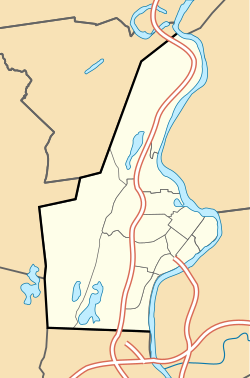
The Flats is a neighborhood in Holyoke, Massachusetts located to the east of the city center, adjacent to the downtown. Although it lies at one of the lowest elevations in Holyoke, its name derives not from topography but from the brick tenement "flats" which characterized its architecture throughout much of its history.[citation needed] Historically the area has also been associated with the name Depot Hill,[2] as it was the location of the city's first freight and passenger railway stations; passenger service was restored at Holyoke station in 2015, following a period of absence after 1967.[3] A section of the neighborhood between Lyman and Appleton Street to north and south respectively, and between Race and Bowers Street to the east and west is also known as Depot Square.[4][5] Today the area features the Holyoke Innovation District, Canal System, Hadley Falls Company Housing District, Marcella Kelly Elementary School, local Amtrak station and 275 acres (111 ha) of residential, commercial, and industrial zoning.
The Flats | |
|---|---|
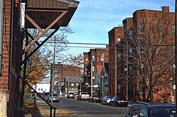  Top to bottom: Brick tenements in a style which characterized the area through much of its history; the Hotel Jess/Perkins Block and other buildings at Depot Square | |
 The Flats  The Flats  The Flats | |
| Coordinates: 42°12′22″N 72°35′41″W / 42.206089°N 72.5947075°W | |
| Country | United States |
| State | Massachusetts |
| City | Holyoke |
| Wards | 1 |
| Precincts | 1A |
| Area | |
| • Total | 0.43 sq mi (1.1 km2) |
| Elevation | 65 ft (20 m) |
| ZIP code | 01040 |
| Area code | 413 |
| MACRIS ID | HLY.W |
The Flats faced mass depopulation following the issuance of city master plans in 1961 and 1968, which called for its conversion from mixed zoning to entirely industrial land use; from 1970 to 1980 this urban renewal initiative, combined with fires from substandard housing conditions and arson, reduced the number of housing units in the neighborhood by 41%.[6]


In recent years municipal and state authorities have sought to redevelop the neighborhood as a startup company incubator and cultural center through the creation of the Innovation District and Canalwalk. Proposals have also been put forth for redevelopment of the historic H. H. Richardson train station as well as the Hotel Jess/Perkins Block.[5] While not on the National Register of Historic Places, the latter holds historical significance as it was constructed by Benjamin F. Perkins, a contemporary of Alexander Graham Bell, who had manufactured and demonstrated early telephone equipment personally for the inventor during his visits to Holyoke, and whose eponymous block was the first headquarters of the Springfield Telephone and Automatic Signal Company, a division of the Bell company, and Western Massachusetts' first telephone exchange, established in 1878.[7][8] That same year the building became one of two sites for the world's first public-use toll line, which connected Springfield and Holyoke when it entered service on June 15, 1878.[9]
References edit
- ^ a b Spatial analysis of "Holyoke Neighborhoods" (PDF). Archived from the original (PDF) on 2 August 2017. Retrieved 3 Jun 2016.
- ^ Tighe, James; Walker, O. W. (1904). "City of Holyoke" (Map). Atlas of Massachusetts. p. 60.
- ^ Brown, Karen (August 28, 2015). "Holyoke Gets Train Stop After 50-Year Absence". New England Public Radio. Retrieved September 13, 2015.
- ^ "Depot Square, Holyoke, MA 01040". Google Maps. Google. Retrieved December 24, 2018.
- ^ a b Laidlaw, Scott (February 2012). Holyoke's Depot Square and the Richardson Train Station; a study of the district's history and historic buildings (PDF) (Report). City of Holyoke Office of Planning and Development; The Center for Design Engagement. Archived from the original (PDF) on March 4, 2016.
- ^ Kegelman, Thomas P. (September 1991). Changing Patterns of Residential Rental Property Investment in Holyoke, Massachusetts (Master of City Planning). Massachusetts Institute of Technology (MIT). Archived from the original on 2018-12-24.
- ^ Lockwood, John (February 18, 2015). "Western Mass. History: Springfield's 'Great Telephone War' of 1870s was David vs. Goliath-type battle". The Republican. Springfield, Mass. Archived from the original on February 21, 2015.
- ^ "When Holyoke First Chatted by Wire; Fiftieth Anniversary of Invention of Telephone Occasion of Reminiscence—Name of Perkins Synonymous with Pioneer Days—Party Lines Original Broadcasting Stations". The Springfield Sunday Union. Springfield, Mass. June 6, 1926. p. 5F.
- ^ "Southern New England Telephone Company: The First Fifty Years, 1878-1928". Thomas J. Dodd Research Center. University of Connecticut. Archived from the original on June 9, 2008.
External links edit
![]() Media related to The Flats, Holyoke, Massachusetts at Wikimedia Commons
Media related to The Flats, Holyoke, Massachusetts at Wikimedia Commons