


Summary
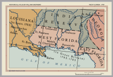
The Floridas (Spanish: Las Floridas) was a region of the southeastern United States comprising the historical colonies of East Florida and West Florida. They were created when England obtained Florida in 1763 (see British Florida), and found it so awkward in geography that she split it in two. The borders of East and West Florida varied. In 1783, when Spain acquired West Florida and re-acquired East Florida from Great Britain through the Peace of Paris (1783), the eastern British boundary of West Florida was the Apalachicola River, but Spain in 1785 moved it eastward to the Suwannee River.[1][2] The purpose was to transfer the military post at San Marcos de Apalachee (now St. Mark's) and the surrounding district from East Florida to West Florida.[3][4] From 1810 to 1813, the United States extended piecemeal control over the part of West Florida that comprised the modern-day Gulf coasts of Alabama and Mississippi and the Florida Parishes of Louisiana. After the ratification of the Adams-Onis Treaty in 1821 the United States combined East Florida and what had been the remaining Spanish-controlled rump of West Florida into the territory that comprised modern-day Florida.
See also edit
References edit
- ^ Wright, J. Leitch (1972). "Research Opportunities in the Spanish Borderlands: West Florida, 1781–1821". Latin American Research Review. 7 (2). Latin American Studies Association: 24–34. JSTOR 2502623.
- ^ Weber, David J. (1992). The Spanish Frontier in North America. New Haven, Connecticut, USA: Yale University Press. p. 275. ISBN 978-0-300-05917-5.
Spain never drew a clear line to separate the two Floridas, but West Florida extended easterly to include Apalachee Bay, which Spain shifted from the jurisdiction of St. Augustine to more accessible Pensacola.
- ^ "The Evolution of a State, Map of Florida Counties – 1820". 10th Circuit Court of Florida. Retrieved 2016-01-26.
Under Spanish rule, Florida was divided by the natural separation of the Suwanee River into West Florida and East Florida.
- ^ Klein, Hank. "History Mystery: Was Destin Once in Walton County?". The Destin Log. Retrieved 2016-01-26.
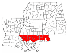
On July 21, 1821 all of what had been West Florida was named Escambia County, after the Escambia River. It stretched from the Perdido River to the Suwanee River with its county seat at Pensacola.
30°N 85°W / 30°N 85°W