


Summary
The Table, sometimes called Table Mountain, is a 2,021-metre (6,631 ft) high flow-dominated andesite tuya located 4 kilometres (2 mi) south of Garibaldi Lake, 15 kilometres (9 mi) northeast of Cheekye and 5 kilometres (3 mi) north of Mount Garibaldi, British Columbia, Canada. It rises over 530 metres (1,740 ft) above the surface of Garibaldi Lake, which lies less than 1 kilometre (1 mi) to the north.
| The Table | |
|---|---|
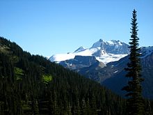
 The Table rises above the southwest side of Garibaldi Lake | |
| Highest point | |
| Elevation | 2,021 m (6,631 ft)[1] |
| Prominence | 251 m (823 ft)[1] |
| Listing | Mountains of British Columbia |
| Coordinates | 49°53′42″N 123°00′47″W / 49.89500°N 123.01306°W[2] |
| Geography | |
 The Table  The Table The Table (Canada) | |
| District | New Westminster Land District |
| Parent range | Garibaldi Ranges |
| Topo map | NTS 92G14 Cheakamus River[2] |
| Geology | |
| Age of rock | Holocene |
| Mountain type | Tuya |
| Volcanic arc/belt | Canadian Cascade ArcGaribaldi Volcanic Belt |
| Last eruption | Holocene |
| Climbing | |
| First ascent | 1916 Tom Fyles |
The Table is almost impossible to climb because sections of the volcano have collapsed, creating steep and exceptionally rotten rock walls on all sides.
Geology edit
The Table is part of the Garibaldi Lake volcanic field, a volcanic field that includes a group of nine small andesitic stratovolcanoes and basaltic andesite vents formed during the early Holocene. This in turn is part of the Garibaldi Volcanic Belt and of the Cascade Volcanic Arc that run from southwestern British Columbia to northern California caused by subduction of the Juan de Fuca Plate and Explorer Plate under the North American Plate at the Cascadia subduction zone.
Canadian geologist Bill Mathews proposed in 1951 that The Table formed when magma intruded into and melted a vertical tube in the overlying Cordilleran Ice Sheet. The partially molten mass of hornblende-phyric andesite cooled as a large block, with gravity flattening its upper surface. Horizontal columns occur at numerous locations along the periphery of the mass. The absence of glacial erosion of the tuya suggests that it erupted during the early Holocene, just prior to the disappearance of the ice sheet. Similar formations can be found in the Wells Gray-Clearwater volcanic field, the Northern Cordilleran Volcanic Province and elsewhere in the Garibaldi Volcanic Belt.
In Film edit
The Table is featured in Agent Cody Banks and in Stargate: The Ark of Truth in which it is the site of the village where the Ark was hidden. The title sequence of the film features The Table, with a graphics overlay of the village superimposed on it, as well as an aerial tour of the Mount Garibaldi and Tantalus Range area.
See also edit

References edit
- ^ a b "The Table". Bivouac.com. Retrieved 2021-06-18.
- ^ a b "The Table". BC Geographical Names. Retrieved 2021-06-18.
- Sources
- Mathews, W. H. (1951). "The Table, a Flat-Topped Volcano in Southern British Columbia". American Journal of Science. 249 (11): 830–841. doi:10.2475/ajs.249.11.830.
- Wood, Charles A.; Kienle, Jürgen, eds. (1990). Volcanoes of North America. Cambridge University Press. ISBN 0-521-43811-X.
- Harris, Stephen L. (2005). Fire Mountains of the West: The Cascade and Mono Lake Volcanoes (3rd ed.). Mountain Press Publishing Company. ISBN 0-87842-511-X.