
KNOWPIA
WELCOME TO KNOWPIA

Thur (France) 
Summary
The Thur (French pronunciation: [tyʁ]) is a river in the Haut-Rhin department, Alsace, France, left tributary of the river Ill. It rises in the Vosges Mountains, and flows through the towns Thann and Cernay. It flows into the Ill (a tributary of the Rhine) near Ensisheim, north of Mulhouse. It is 53 km (33 mi) long.[1]
| Thur | |
|---|---|
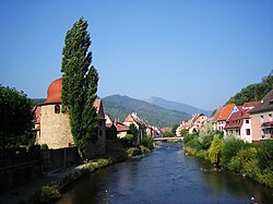 The Thur in Thann | |
  | |
| Location | |
| Country | France |
| Department | Haut-Rhin |
| Physical characteristics | |
| Source | |
| • location | Vosges mountains |
| • elevation | ±950 m (3,120 ft) |
| Mouth | |
• location | river Ill |
• coordinates | 47°52′32″N 7°20′34″E / 47.87556°N 7.34278°E |
| Length | 53 km (33 mi) |
| Basin size | 262 km2 (101 sq mi) |
| Discharge | |
| • average | 5.5 m3/s (190 cu ft/s) |
| Basin features | |
| Progression | Ill→ Rhine→ North Sea |
References edit