


Summary
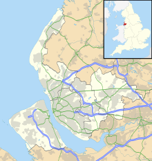
Thurstaston Common is an area of almost 250 acres (100 ha) of parklands, wood and heath between Frankby and Thurstaston, on the Wirral Peninsula in North West England. The common is jointly owned by the National Trust and the Metropolitan Borough of Wirral. Royden Country Park is nearby and offers additional facilities.
| Site of Special Scientific Interest | |
 | |
 Location within Merseyside | |
| Location | Merseyside |
|---|---|
| Grid reference | SJ245851 |
| Coordinates | 53°21′18″N 3°08′06″W / 53.355°N 3.135°W |
| Interest | Biological and Geological |
| Area | 70.8 hectares, 174.9 acres (708,000 m2) |
| Notification | 1954 / 1983 |
| Natural England website | |
The Common is a Site of Special Scientific Interest (SSSI)[1][2] and a local nature reserve.[3][4][5] From the top of the 298 ft (91 m) Thurstaston Hill there are views of the Dee Estuary (itself an SSSI) and across to the Clwydian Hills of North Wales. The area is popular with walkers and families.
SSSI edit
The common is underlain by Triassic sandstone and the varied habitats include wet and dry heaths, acidic marshy grassland and deciduous woodland with birch and oak. The heath is dominated by heather, with bilberry, wavy hair-grass, gorse, heath grass, tormentil, hairy sedge, pill sedge and heath bedstraw, with cross-leaved heath and purple moor-grass; in the wet, peaty hollows are heath rush, common cottongrass and hare's-tail cottongrass, deer grass, Sphagnum compactum, bog asphodel and bulbous rush. Also present in wet patches are oblong-leaved sundew and round-leaved sundew. Birds that breed here include sparrowhawk, tawny owl, great spotted woodpecker, lesser spotted woodpecker, Eurasian jay, redpoll and linnet.[1]
"Thor's Stone" edit

Thurstaston Hill is the location of Thor's Stone, a large sandstone outcrop and a place of romantic legend. In the 19th century it was supposed that early Viking settlers may have held religious ceremonies here. A visit to the site by members of the British Archaeological Association in 1888 heard an account by Rev. A. E. P. Gray, rector of Wallasey, that the 'Thor Stone' was also known in the locality as 'Fair Maiden's Hall' and that children were "in the habit of coming once a year to dance around the stone".[6] This part of Wirral was certainly part of a Norse colony centred on Thingwall in the 10th and 11th centuries. However, geologists and historians now think that the rock is a natural formation similar to a tor, arising from periglacial weathering of the sandstone, which was later exploited by quarrymen in the 18th and 19th centuries.[7]
Gallery edit
-
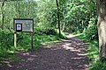 The path from School Lane
 -
 Pathway on Thurstaston Hill
 -
 Looking towards Arrowe Park and Liverpool
 -
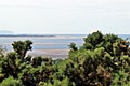 The view to Point of Ayr


References edit
- ^ a b "Thurstaston Common citation" (PDF). Sites of Special Scientific Interest. Natural England. Retrieved 26 July 2013.
- ^ "Map of Thurstaston Common". Sites of Special Scientific Interest. Natural England. Retrieved 26 July 2013.
- ^ "Thurstaston Common". Local Nature Reserves. Natural England. Retrieved 26 July 2013.
- ^ "Map of Thurstaston Common". Local Nature Reserves. Natural England. Retrieved 26 July 2013.
- ^ "Thurstaston Common Nature Reserve". Wirral Council. Retrieved 28 January 2011.
- ^ Journal of the British Archaeological Association, 1888
- ^ Stephen J. Roberts, A History of Wirral, 2002, ISBN 978-1-86077-512-3
It was a Viking place of sacrifice
External links edit
- Metropolitan Borough of Wirral: Royden Park & Thurstaston Common LNR
- BBC: Thor's Stone