


Summary
Timimoun (Berber languages: ⵜⵉⵎⵉⵎⵓⵏ, Arabic: ﺗﻴﻤﻴﻤﻮن) is a town and commune, and capital of Timimoun District, in Adrar Province, south-central Algeria. According to the 2008 census it has a population of 33,060,[1] up from 28,595 in 1998,[2] with an annual growth rate of 1.5%.[1]
Timimoun
ⵜⵉⵎⵉⵎⵓⵏ ﺗﻴﻤﻴﻤﻮن | |
|---|---|
Town and commune | |
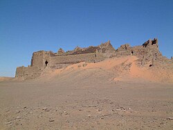 Ksar of Timimoun | |
 Location of Timimoun commune within Adrar Province | |
 Timimoun Location of Timimoun within Algeria | |
| Coordinates: 29°15′46″N 0°14′20″W / 29.26278°N 0.23889°W | |
| Country | Algeria |
| Province | Adrar |
| District | Timimoun |
| Elevation | 288 m (945 ft) |
| Population (2008)[1] | |
| • Total | 33,060 |
| Time zone | UTC+1 (CET) |
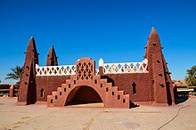
Timimoun is known for the red ochre color of its buildings.
Geography edit
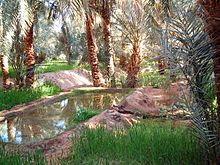
The town of Timimoun lies at an elevation of around 288 metres (945 ft) in the Gourara region of northern Adrar Province. It is located on the south-eastern side of an oasis which supports the town's population. A sebkha (salt lake) lies further to the northwest, while the plateau of Tademaït rises to the southeast.
Climate edit
Timimoun has a hot desert climate (Köppen climate classification BWh), with extremely hot summers and warm winters, with minimal rainfall throughout the year. The annual mean temperature almost reaches 25 °C (77 °F).
| Climate data for Timimoun | |||||||||||||
|---|---|---|---|---|---|---|---|---|---|---|---|---|---|
| Month | Jan | Feb | Mar | Apr | May | Jun | Jul | Aug | Sep | Oct | Nov | Dec | Year |
| Mean daily maximum °C (°F) | 19.3 (66.7) |
22.1 (71.8) |
27.5 (81.5) |
32.2 (90.0) |
36.8 (98.2) |
42.0 (107.6) |
45.5 (113.9) |
44.0 (111.2) |
39.6 (103.3) |
33.1 (91.6) |
25.0 (77.0) |
19.9 (67.8) |
32.3 (90.1) |
| Daily mean °C (°F) | 12.2 (54.0) |
14.8 (58.6) |
19.8 (67.6) |
24.2 (75.6) |
28.7 (83.7) |
33.6 (92.5) |
37.1 (98.8) |
36.0 (96.8) |
32.1 (89.8) |
25.9 (78.6) |
18.0 (64.4) |
13.3 (55.9) |
24.6 (76.4) |
| Mean daily minimum °C (°F) | 5.2 (41.4) |
7.6 (45.7) |
12.1 (53.8) |
16.2 (61.2) |
20.7 (69.3) |
25.1 (77.2) |
28.8 (83.8) |
28.0 (82.4) |
24.6 (76.3) |
18.7 (65.7) |
11.1 (52.0) |
6.8 (44.2) |
17.1 (62.8) |
| Average precipitation mm (inches) | 2.2 (0.09) |
1.8 (0.07) |
2.3 (0.09) |
2.2 (0.09) |
1.4 (0.06) |
0.1 (0.00) |
0.0 (0.0) |
0.2 (0.01) |
0.6 (0.02) |
2.6 (0.10) |
0.9 (0.04) |
1.7 (0.07) |
16 (0.64) |
| Source: Global climatology for Timimoun, Algeria (2000 - 2015)[3] | |||||||||||||
Transportation edit
Timimoun lies on the N51 national highway, a road which runs roughly west to east from the N6 (connecting to Béchar in the north and Adrar in the south) to the N1 (connecting from Ghardaïa in the north to In Salah and Tamanrasset in the south). Regional roads also lead south to Aougrout and Deldoul communes, and north to Tinerkouk, Ksar Kaddour and Ouled Said.
Timimoun is served by Timimoun Airport,[4] which is about 5 kilometres (3.1 mi) southeast of the town.
Education edit
7.0% of the population has a tertiary education, and another 19.3% has completed secondary education.[5] The overall literacy rate is 79.6%, and is 87.5% among males and 71.8% among females.[6]
Carpets edit


Localities edit
As of 1984, the commune was composed of 32 localities:[7]
- Timimoun
- Tala
- Tinoumeur
- Bouyahia
- Ouled Nouh
- Zaouiet Sidi Hadj Belkacem
- Beni Melhal
- Beni Mellouk
- Ouadjda
- Taoursit
- Massahel
- Tsmana
- Azekkour
- Tarouaïa
- Alamellal
- Aghiat
- Massine
- El Barka
- Ouamemi
- Amakbour
- Amezgar
- Kef Elkasbah
- Kef Elksar
- Béni Guentour Lahmer
- Samjane
- Taounza
- Hiha
- Yakou
- El Kort
- Tilaghmine
- Timazlane
- Béni Aïssi Sidi Mansour Tganet
References edit
- ^ a b c "Population: Wilaya d'Adrar" (PDF) (in French). Office National des Statistiques Algérie. Retrieved 1 July 2013.
- ^ "Algeria Communes". Statoids. Retrieved 8 March 2013.
- ^ "Timimoun, Algeria". Infoclimat. October 2013. Retrieved 31 May 2013.
- ^ "Timimoun Airport". OurAirports.com. Retrieved 27 October 2013.
- ^ "Structure relative de la population résidente des ménages ordinaires et collectifs âgée de 6 ans et plus selon le niveau d'instruction et la commune de résidence" (PDF) (in French). Office National des Statistiques Algérie. Retrieved 1 July 2013.
- ^ "Taux d'analphabétisme et taux d'alphabétisation de la population âgée de 15 ans et plus, selon le sexe et la commune de résidence " (PDF) (in French). Office National des Statistiques Algérie. Retrieved 1 July 2013.
- ^ "Décret n° 84-365, fixant la composition, la consistance et les limites territoriale des communes. Wilaya d'Adrar" (PDF) (in French). Journal officiel de la République Algérienne. 19 December 1984. p. 1473. Archived from the original (PDF) on 2012-01-15. Retrieved 1 July 2013.