
KNOWPIA
WELCOME TO KNOWPIA

Tjeldsund Bridge 
Summary
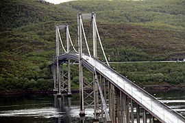
The Tjeldsund Bridge (Norwegian: Tjeldsundbrua) is a suspension road bridge that crosses the Tjeldsundet strait between the mainland and the island of Hinnøya in Troms county, Norway. The bridge is 1,007 metres (3,304 ft) long, the main span is 290 metres (950 ft), and the maximum clearance to the sea is 41 metres (135 ft). The bridge has 32 spans.[5][6][7]
Tjeldsund Bridge Tjeldsundbrua | |
|---|---|
 Tjeldsund bridge | |
| Coordinates | 68°37′42″N 16°34′43″E / 68.628235°N 16.578712°E |
| Carries | |
| Crosses | Tjeldsundet |
| Locale | Troms, Norway |
| Characteristics | |
| Design | suspension road bridge |
| Material | Steel and cement |
| Total length | 1,007 metres (3,304 ft) |
| Width | 9.3 metres (31 ft) |
| Longest span | 290 metres (950 ft) |
| No. of spans | 32 |
| Clearance below | 41 metres (135 ft) |
| History | |
| Construction cost | 45 million kr |
| Opened | 22 October 1967[1][2][3][4] |
| Location | |
 | |
After 30 months and 375,000 work hours, 112,000 bags of cement, 1200 tons of steel and the cost of 45 million kr, Tjeldsund Bridge was opened by King Olav V on 22 August 1967.[8]
The bridge carries the European route E10 highway, connecting the municipalities of Harstad and Tjeldsund. It is part of a network of bridges that connect the islands of Vesterålen and Lofoten to the mainland.
Gallery edit
-
 Tjeldsundbrua lighted at night
 -
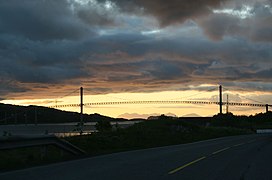 Tjeldsundbrua at dusk
 -
 Tjeldsundbrua
 -
 Tjeldsundbrua


References edit
- ^ "Kong Olav og Magnar Hellebust under åpningen av Tjeldsundbrua".
- ^ "Tjeldsundbrua under bygging".
- ^ "Geocaching - the Official Global GPS Cache Hunt Site".
- ^ "Tilbakeblikk til da Tjeldsundbrua åpnet 22. Oktober 1967". 19 October 2017.
- ^ "Tjeldsund Bridge". Bridge-Info.org. Retrieved 2012-08-23.
- ^ Merzagora, Eugenio A. (ed.). "Road Viaducts & Bridges in Norway (> 500 m)". Norske bruer og viadukter. Retrieved 2012-08-23.
- ^ Tjeldsund Bridge at Structurae. Retrieved 2012-08-23.
- ^ Historie_om_Tjeldsundbrua Archived 2005-08-27 at the Wayback Machine (Norwegian)
External links edit
Wikimedia Commons has media related to Tjeldsundbrua.
- Picture of Tjeldsund Bridge
- Updated weather information for bridges & mountain crossings northern Norway