


Summary
Todzhinsky District (Russian: Тоджи́нский кожуун; Tuvan: Тожу кожуун, Toju kojuun) is an administrative[1] and municipal[2] district (raion, or kozhuun), one of the seventeen in the Tuva Republic, Russia. It is located in the northeast of the republic. The area of the district is 44,800 square kilometers (17,300 sq mi).[2] Its administrative center is the rural locality (a selo) of Toora-Khem.[1] Population: 6,020 (2010 Census);[3] 5,931 (2002 Census);[6] 6,448 (1989 Census).[7] The population of Toora-Khem accounts for 39.7% of the district's total population.[3]
Todzhinsky District
Тоджинский кожуун | |
|---|---|
| Other transcription(s) | |
| • Tuvan | Тожу кожуун |
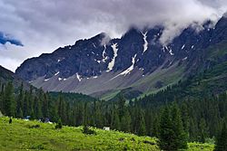 Sayan, in Todzhinsky District | |
 Flag  Coat of arms | |
 Location of Todzhinsky District in the Tuva Republic | |
| Coordinates: 52°46′41″N 96°54′40″E / 52.778°N 96.911°E | |
| Country | Russia |
| Federal subject | Tuva Republic[1] |
| Administrative center | Toora-Khem[1] |
| Area | |
| • Total | 44,800 km2 (17,300 sq mi) |
| Population | |
| • Total | 6,020 |
| • Estimate (2018)[4] | 6,545 (+8.7%) |
| • Density | 0.13/km2 (0.35/sq mi) |
| • Urban | 0% |
| • Rural | 100% |
| Administrative structure | |
| • Administrative divisions | 6 sumon |
| • Inhabited localities[1] | 7 rural localities |
| Municipal structure | |
| • Municipally incorporated as | Todzhinsky Municipal District[2] |
| • Municipal divisions[2] | 0 urban settlements, 6 rural settlements |
| Time zone | UTC+7 (MSK+4 |
| OKTMO ID | 93650000 |
| Website | http://todzhinsky.ru/ |
Geography and economy edit
The district is located in the isolated part of the republic, far from its developed regions.[2] As a result, its location impedes the economic development of the territory and infrastructure.[2] Ship transport is the main means of communication with the rest of the republic in summer.[2] The district border Piy-Khemsky and Kyzylsky District to the southwest, Kaa-Khemsky District to south and southeast, Kuraginsky and Karatuzsky District of Krasnoyarsk Krai to the northwest and west, Nizhneudinsky District of Irkutsk Oblast to the northeast, Okinsky District of Republic of Buryatia in the east.
See also edit
References edit
Notes edit
- ^ a b c d e Resolution #1648 ZP-1
- ^ a b c d e f g h Law #268 VKh-1
- ^ a b c Russian Federal State Statistics Service (2011). Всероссийская перепись населения 2010 года. Том 1 [2010 All-Russian Population Census, vol. 1]. Всероссийская перепись населения 2010 года [2010 All-Russia Population Census] (in Russian). Federal State Statistics Service.
- ^ "26. Численность постоянного населения Российской Федерации по муниципальным образованиям на 1 января 2018 года". Federal State Statistics Service. Retrieved January 23, 2019.
- ^ "Об исчислении времени". Официальный интернет-портал правовой информации (in Russian). June 3, 2011. Retrieved January 19, 2019.
- ^ Russian Federal State Statistics Service (May 21, 2004). Численность населения России, субъектов Российской Федерации в составе федеральных округов, районов, городских поселений, сельских населённых пунктов – районных центров и сельских населённых пунктов с населением 3 тысячи и более человек [Population of Russia, Its Federal Districts, Federal Subjects, Districts, Urban Localities, Rural Localities—Administrative Centers, and Rural Localities with Population of Over 3,000] (XLS). Всероссийская перепись населения 2002 года [All-Russia Population Census of 2002] (in Russian).
- ^ Всесоюзная перепись населения 1989 г. Численность наличного населения союзных и автономных республик, автономных областей и округов, краёв, областей, районов, городских поселений и сёл-райцентров [All Union Population Census of 1989: Present Population of Union and Autonomous Republics, Autonomous Oblasts and Okrugs, Krais, Oblasts, Districts, Urban Settlements, and Villages Serving as District Administrative Centers]. Всесоюзная перепись населения 1989 года [All-Union Population Census of 1989] (in Russian). Институт демографии Национального исследовательского университета: Высшая школа экономики [Institute of Demography at the National Research University: Higher School of Economics]. 1989 – via Demoscope Weekly.
Sources edit
- Законодательная палата Великого Хурала Республики Тыва. Постановление №1648 ЗП-1 от 21 декабря 2005 г. «Об утверждении реестра административно-территориального деления Республики Тыва», в ред. Постановления №455 ЗП-2 от 21 ноября 2007 г «О внесении изменения в реестр административно-территориального деления Республики Тыва». Вступил в силу 21 декабря 2005 г. Опубликован: "Тувинская правда", №2, 12 января 2006 г. (Legislative Chamber of the Great Khural of the Tyva Republic. Resolution #1648 ZP-1 of December 21, 2005 On Establishing the Registry of the Administrative-Territorial Division of the Tyva Republic, as amended by the Resolution #455 ZP-2 of November 21, 2007 On Amending the Registry of the Administrative-Territorial Division of the Tyva Republic. Effective as of December 21, 2005.).
- Великий Хурал (парламент) Республики Тыва. Закон №268 ВХ-1 от 24 декабря 2010 г. «О статусе муниципальных образований Республики Тыва», в ред. Закона №837 ВХ-1 от 10 октября 2011 г. «О внесении изменений в Закон Республики Тыва "О статусе муниципальных образований Республики Тыва"». Вступил в силу со дня официального опубликования. Опубликован: "Тувинская правда", №178 (без приложений), 31 декабря 2010 г. (Great Khural (Parliament) of the Tyva Republic. Law #268 VKh-1 of December 24, 2010 On the Status of the Municipal Formations of the Tyva Republic, as amended by the Law #837 VKh-1 of October 10, 2011 On Amending the Law of the Tyva Republic "On the Status of the Municipal Formations of the Tyva Republic". Effective as of the official publication date.).