
KNOWPIA
WELCOME TO KNOWPIA

Tokosha Mountains 
Summary
Tokosha Mountains is a 6,148 ft (1,870 m) multi-peak massif located in the Alaska Range, in Denali National Park and Preserve, in Alaska, United States. It is situated between the toes of Ruth Glacier and Tokositna Glacier, 27 mi (43 km) south-southeast of Denali and 26 mi (42 km) northwest of Talkeetna.[3] Despite its relatively low elevation, it is notable for its Teton-esque granite spires which can be seen from the George Parks Highway.
| Tokosha Mountains | |
|---|---|
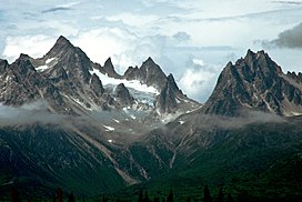 Tokosha Mountains, east aspect | |
| Highest point | |
| Elevation | 6,148 ft (1,874 m)[1] |
| Prominence | 2,898 ft (883 m)[2] |
| Isolation | 10.12 mi (16.29 km)[1] |
| Coordinates | 62°43′0″N 150°37′54″W / 62.71667°N 150.63167°W[2] |
| Geography | |
 Tokosha Mountains Location of Tokosha Mountains in Alaska | |
| Location | Matanuska-Susitna Borough, Alaska, United States |
| Parent range | Alaska Range |
| Topo map | USGS Talkeetna C-2 |
| Geology | |
| Type of rock | Granite |
| Climbing | |
| First ascent | 1975 by David Johnston and Brian Okonek |
History edit
In the Denaʼina language, tokosha means "treeless" or "treeless area". The mountain was named in by 1906 by explorer Belmore Browne of the Cook Expedition which attempted to climb Denali. The first ascent of Grand Tokosha was made on March 3, 1975 by David Johnston and Brian Okonek.[4]
See also edit
References edit
- ^ a b "Tokosha Mountains AK - 6,148'". listsofjohn.com. Retrieved 2020-07-08.
- ^ a b "Grand Tokosha". Peakbagger.com. Retrieved 2019-05-19.
- ^ "Tokosha Mountains". Geographic Names Information System. United States Geological Survey, United States Department of the Interior. Retrieved 2019-05-19.
- ^ American Alpine Club
Gallery edit


External links edit
- Weather forecast: Tokosha Mountains