
KNOWPIA
WELCOME TO KNOWPIA

Tolga (village) 
Summary
Tolga is the administrative centre of Tolga Municipality in Innlandet county, Norway. The village is located along the river Glåma, about 15 kilometres (9.3 mi) down river from the village of Os i Østerdalen and about 20 kilometres (12 mi) northeast of the village of Tynset. To the southeast of the village, lies the long Hodalen valley where the villages of Hodalen and Øversjødalen are located.[3]
Tolga | |
|---|---|
Village | |
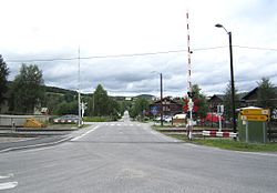 View of the village | |
 Tolga Location of the village  Tolga Tolga (Norway) | |
| Coordinates: 62°24′32″N 10°59′56″E / 62.40899°N 10.99877°E | |
| Country | Norway |
| Region | Eastern Norway |
| County | Innlandet |
| District | Østerdalen |
| Municipality | Tolga Municipality |
| Area | |
| • Total | 1.05 km2 (0.41 sq mi) |
| Elevation | 543 m (1,781 ft) |
| Population (2021)[1] | |
| • Total | 583 |
| • Density | 558/km2 (1,450/sq mi) |
| Time zone | UTC+01:00 (CET) |
| • Summer (DST) | UTC+02:00 (CEST) |
| Post Code | 2540 Tolga |
The 1.05-square-kilometre (260-acre) village has a population (2021) of 583 and a population density of 558 inhabitants per square kilometre (1,450/sq mi).[1]
The large, octagonal Tolga Church is located in the village.[3]
The Rørosbanen railway line runs through the village, stopping at Tolga Station.
References edit
- ^ a b c Statistisk sentralbyrå (1 January 2021). "Urban settlements. Population and area, by municipality".
- ^ "Tolga, Tolga". yr.no. Retrieved 2022-02-06.
- ^ a b Mæhlum, Lars, ed. (2021-11-01). "Tolga (tettstad)". Store norske leksikon (in Norwegian). Kunnskapsforlaget. Retrieved 2022-02-06.