
KNOWPIA
WELCOME TO KNOWPIA

Tomasee 
Summary
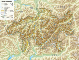
The Tomasee (Romansh: Lai da Tuma or Lag da Toma) is a lake at the northern face of Piz Badus, above the village of Tschamut in Grisons, Switzerland. Its surface area is 2.5 ha (6.2 acres).
| Tomasee | |
|---|---|
| Lai da Tuma | |
 | |
 Tomasee  Tomasee  Tomasee  Tomasee | |
| Location | Grisons |
| Coordinates | 46°37′57″N 8°40′20″E / 46.63250°N 8.67222°E |
| Primary inflows | Rein da Tuma |
| Primary outflows | Rein da Tuma |
| Basin countries | Switzerland |
| Surface area | 2.5 ha (6.2 acres) |
| Surface elevation | 2,345 m (7,694 ft) |
 | |
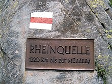
It is the source of the Anterior Rhine and is deemed to be the official source of the Rhine (the source of the Posterior Rhine is above Hinterrhein, Switzerland, at 46°29′56″N 9°03′54″E / 46.499°N 9.065°E).
It is possible to reach the lake on a path from Oberalp Pass, suitable for most walkers although still a mountain trail.[1]
Notes edit
- ^ (in English) Hike Switzerland to the source of the Rhine in Graubünden
External links edit
 Media related to Tomasee at Wikimedia Commons