


Summary
Tongariki Island is an inhabited island in Shefa Province of Vanuatu in the Pacific Ocean. The island is a part of Shepherd Islands archipelago.[1][2]
 | |
| Geography | |
|---|---|
| Location | Pacific Ocean |
| Coordinates | 17°1′S 168°37′E / 17.017°S 168.617°E |
| Archipelago | Vanuatu, Shepherd Islands |
| Highest elevation | 521 m (1709 ft) |
| Administration | |
| Province | Shefa Province |
| Demographics | |
| Population | 274 (2015) |
Geography edit
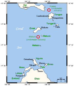
Tongariki is a small island of volcanic origin located in the eastern Shepherd Islands, having no beaches or reefs. Several small islands lie close to the south coast. The island is 3.8 km long and 1.7 km wide.[3] The estimated highest terrain elevation above the sea level is some 521 metres.[4] The uninhabited island of Falea lies 1.8 km north-west of Tongariki.The island consist of five villages known as Tavia, Lewaima, Lakilia , mu-ura and Erata.
Population edit
As of 2015, the official local population was 274 people in 55 households.[5] The main village is Erata. Some local people speak Namakura language.
References edit
- ^ "Tongariki: Vanuatu". Geographic Names. Retrieved 9 August 2018.
- ^ "Shepherd Islands". Vanuatu Travel. Retrieved 9 August 2018.
- ^ "Shepherd group of islands". Vanuatu Islands Travel Info. Retrieved 10 August 2018.
- ^ "Tongariki Island". Mapcarta. Retrieved 9 August 2018.
- ^ "2015 Vanuatu National Population and Households Projections by Province and Islands" (PDF). Vanuatu National Statistics Office. Retrieved 9 August 2018.