
KNOWPIA
WELCOME TO KNOWPIA

Topock Gorge 
Summary
Topock Gorge is a mountainous canyon and gorge section of the Colorado River, located between Interstate 40 and Lake Havasu. The town of Needles, California, to the northwest, was named for the "needle-like" vertical rock outcroppings. The natural landmarks and river crossing by them were one of the journey markers for travelers on historic Route 66.[citation needed]
| Topock Gorge | |
|---|---|
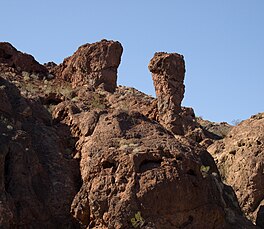 Rock formations in Topock Canyon on the Colorado River, 2010 | |
 Topock Gorge | |
| Location | Mohave County, Arizona / San Bernardino County, California, United States |
| Coordinates | 34°39′40″N 114°27′19″W / 34.66111°N 114.45528°W |
| Basin countries | United States |
| Average depth | 15 ft (4.6 m) |
| Surface elevation | 500 ft (150 m) |
| References | GNIS data |
Havasu National Wildlife Refuge edit
The Topock Gorge is within the Havasu National Wildlife Refuge, managed by the United States Fish and Wildlife Service.[1] It features natural habitat, wildlife, scenic preservation, and archeology. Mojave people Indian petroglyphs are in the Gorge.
Fish species edit
Amphibians
Wikimedia Commons has media related to Topock Gorge.
References edit
- ^ "Havasu National Wildlife Refuge" (PDF). United States Fish and Wildlife Service. Archived from the original (PDF) on 2011-07-16. Retrieved 2010-06-22.
- U.S. Fish and Wildlife Service: Havasu Wilderness Area – brochure
External links edit
- Official Havasu National Wildlife Refuge website
- Great Blog with tons of pictures and video of the Topock Gorge
- Arizona Boating Locations Facilities Map
- Arizona Fishing Locations Map