
KNOWPIA
WELCOME TO KNOWPIA

Trekanten (Kristiansand) 
Summary
Trekanten is a neighbourhood in the city of Kristiansand in Agder county, Norway. It is located in the borough of Vågsbygd and in the district of Slettheia.[1] The neighborhood includes a large commercial area.
Trekanten | |
|---|---|
Neighborhood in Kristiansand | |
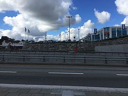 View of the Fv456 road and Trekanten centre | |
 Trekanten Location of the neighborhood  Trekanten Trekanten (Norway) | |
| Coordinates: 58°07′45″N 7°57′43″E / 58.1292°N 07.9619°E | |
| Country | Norway |
| County | Agder |
| Municipality | Kristiansand |
| Borough | Vågsbygd |
| District | Slettheia |
| Elevation | 19 m (62 ft) |
| Time zone | UTC+01:00 (CET) |
| • Summer (DST) | UTC+02:00 (CEST) |
| Postal code | 4621 |
| Area code | 38 |
It is located around a triangle formed by the junction of three arterial roads within Vågsbygd borough in Slettheia (its name means The Triangle in English). Trekanten is next to Norwegian County Road 456, which in June 2014 was transferred into a new 1.3-kilometre (0.81 mi) dual carriageway tunnel emerging at Trekanten.[2]
The centre contains various shops, offices, child welfare, and healthcare facilities.
Transportation edit
| Line | Destination |
|---|---|
| M1 | Flekkerøy - Sørlandsparken-Dyreparken-IKEA |
| M1[3] | Flekkerøy - Kvadraturen |
| M2 | Voiebyen - Hånes |
| M2 | Voiebyen - Hånes-Lauvåsen |
| M3 | Slettheia - Søm |