


Summary
The Trempealeau River (pronounced TREM-puh-lo, from the French trempe à l'eau, dip in water) is an 81.5-mile-long (131.2 km)[1] tributary of the Mississippi River in the Driftless Area of western Wisconsin in the United States.


Course edit
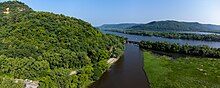
The Trempealeau River rises in western Jackson County as two streams, its North and South Branches; the South Branch has at times been known as the main stem of the river, and the North Branch has at times been known as "Bovee Creek". The two streams join just east of Hixton, and the Trempealeau initially flows generally westwardly into Trempealeau County, past Hixton, Taylor, Blair, Whitehall and Independence. Near Independence, the river turns to the southwest and flows past Arcadia; in its lower course, it is used to define the boundary between Trempealeau and Buffalo counties. The Trempealeau flows into the Mississippi River just downstream of Winona, Minnesota at Perrot State Park.
Gallery edit
 |
 |
See also edit
References edit
- ^ U.S. Geological Survey. National Hydrography Dataset high-resolution flowline data. The National Map, accessed October 5, 2012
- Columbia Gazetteer of North America entry
- DeLorme (1992). Wisconsin Atlas & Gazetteer. Freeport, Maine: DeLorme. ISBN 0-89933-247-1.
- U.S. Geological Survey Geographic Names Information System: Trempealeau River
- U.S. Geological Survey Geographic Names Information System: North Branch Trempealeau River
- U.S. Geological Survey Geographic Names Information System: South Branch Trempealeau River
External links edit
 Media related to Trempealeau River at Wikimedia Commons
44°19′37″N 91°27′14″W / 44.327037°N 91.454011°W