


Summary
Troubridge Island is an island located in the south west corner of Gulf St Vincent in South Australia near the eastern edge of the Troubridge Shoals off the east coast of Yorke Peninsula about 8 kilometres (5.0 mi) southeast by east of the town of Edithburgh It is notable for being a site of an operating lighthouse from 1856 until 2002 and as a site for a sea bird rookery. Since 1982, the island has been part of the Troubridge Island Conservation Park.
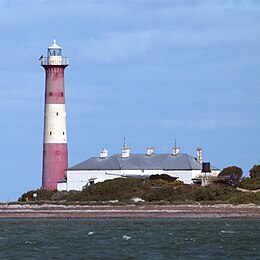 Troubridge Island Lighthouse | |
 Troubridge Island | |
| Geography | |
|---|---|
| Location | Gulf St Vincent |
| Coordinates | 35°07′04″S 137°49′38″E / 35.11766°S 137.82733°E |
| Area | 2 ha (4.9 acres)[1] |
| Highest elevation | 5 m (16 ft)[1] |
| Administration | |
Australia | |
Description edit
Troubridge Island is located approximately 8 kilometres (5.0 mi) southeast by east of the town of Edithburgh near the eastern edge of the Troubridge Shoals. It is a ‘crest of sand’ which is permanently above high tide and which is stabilised by the presence of vegetation. At high water, the Island had an area of 2 hectares (4.9 acres) and a height of 5 metres (16 feet) as of 1996. At low water, its intertidal zone extends for at least one kilometre (0.62 mi) from its high water mark. The island is most accessible at high tide, when there is sufficient water over the intertidal zone to allow a boat reach the permanently dry land. Since 1988, access to the island has been restricted to these with permits provided by the Department of Environment, Water and Natural Resources.[2][3][4][5]
Flora and fauna edit
Flora edit
Most of the 31 plant species recorded from the island are introduced. The vegetation consists of low shrubland dominated by nitre bush, grey saltbush and African boxthorn. Other prominent plants present are tree mallow, sea rocket, marram grass and hairy spinifex.[6]
Fauna edit
Fauna on Troubridge Island is represented by both birds and reptiles. As of 2009, almost 60 native bird species have been recorded including 21 species of conservation significance and 22 species listed as migratory. Dominant species include black-faced cormorants, Caspian terns, crested terns and fairy terns, Pacific gulls, little penguins, pied cormorants and silver gulls.[7]
As of 1996, starlings, an introduced species, is reported as having a population of 10,000 and was "competing with native species for roosting sites and fouling the keepers' cottages."[8] The following reptile species have been recorded on Troubridge Island: marbled geckos and sleepy lizards.[7]
Little penguin colony edit
Troubridge Island's little penguin colony was approximately 3000-5000 birds during the 1980s. In 2009, its population was estimated to be 3010 breeding adults. In 2011, the colony was believed to be stable.[9] A census conducted in 2013 estimated a total population of 270 breeding adults, showing a severe and unexplained decline.[10]

History edit
European discovery and use edit
Matthew Flinders discovered the Troubridge Shoals on 1 April 1802, however he did not report the existence of the island.[11]
A lighthouse known as the Troubridge Island Lighthouse was erected on the island as a means to reduce shipping losses caused by the strandings on the Troubridge Shoals. It was first lit in 1856. It was converted to automatic operation in 1981 and its role as a navigation aid was taken over progressively from 1980 by a new lighthouse located on Troubridge Hill on Yorke Peninsula to the west of Troubridge Island. It was decommissioned in 2001.[1][12]
In 1981, the island was sold to the South Australian Government who proceeded with the establishment of the Troubridge Island Conservation Park. The land associated with the lighthouse being leased by the Australian Maritime Safety Authority (AMSA). In 1993, the lease was transferred to the South Australian Government for the remainder of its term.[1][2][13]
Troubridge Shoals edit
Troubridge Island is part of Troubridge Shoals which extend across to Yorke Peninsula and constitutes a hazard to shipping. Troubridge Shoals has been the cause of over 33 wrecks and groundings. During the period October 1849 to May 1850, at least seven vessels ran aground.[14] precipitating the erection of a lighthouse in 1855.
When the Parsee was wrecked on the shoals on 13 November 1838 the survivors landed at the adjacent Troubridge Island.[15][16]
Marion Reef, south of Troubridge Island, was named for the Marion, which ran aground in 1851 as did many others, has been (incorrectly) identified as part of Troubridge Shoals.[17]
Protected areas status edit
Statutory edit
Troubridge Island has been part of the Troubridge Island Conservation Park since 1982. In 1986, the park was extended for a distance about 1 kilometre (0.62 miles) around the island to cover most of the sandbar of which the island is part. Since 2012, the island has been located within the boundaries of the Lower Yorke Peninsula Marine Park.[18][19]
Non-statutory edit
The island (and some of the adjoining sandbar exposed at low tide) has been nominated as an Important Bird Area (IBA) known as the Troubridge Island Important Bird Area by BirdLife International. The basis for the nomination is that the IBA supports over 1% of the world populations of both black-faced cormorants (with up to 4000 individuals) and silver gulls (with up to 10,000 breeding pairs) as well as supporting "significant numbers of the vulnerable Fairy Tern".[20]
See also edit
Citations edit
- ^ a b c d Robinson et al, 1996, page 290
- ^ a b Robinson et al, 1996, page 292
- ^ Robinson et al, 1996, page 293
- ^ DEH, 2009, page 12
- ^ DMH, 1985, chart 20
- ^ "Troubridge Island". BirdLife Australia. Retrieved 18 August 2014.
- ^ a b DEH, 2009, pages 20-22
- ^ DEH, 2009, page 23
- ^ Wiebkin, 2011, pages 10-11
- ^ Colombelli-Négrel & Kleindorfer, 2014, pages 18, 22 & 23
- ^ Flinders, 2014 (1966), page 257-258
- ^ Coroneos & McKinnon, 1997, page 18
- ^ DEH, 2009, page 35.
- ^ "Shipping Intelligence". South Australian Register. Adelaide. 11 May 1850. p. 2. Retrieved 18 August 2014 – via National Library of Australia.
- ^ "WRECK OF THE PARSEE". Southern Australian. Adelaide, SA. 24 November 1838. p. 2. Retrieved 7 September 2018 – via National Library of Australia.
- ^ Alison Painter, 13 November 1838 Parsee wreck Professional Historians Australia (SA). Retrieved 7 September 2018.
- ^ "Wreck of the Ship "Marion" on Troubridge Shoal". South Australian Register. Adelaide. 2 August 1851. p. 2. Retrieved 19 August 2014 – via National Library of Australia.
- ^ DEH, 2009, pages 2-3
- ^ DEWNR, 2012, pages 2-3
- ^ BI, 2015
References edit
- Colombelli-Négrel, D.; Kleindorfer, S (2009). Penguin monitoring and conservation activities in the Gulf St Vincent July 2013 – June 2014 Report to the Adelaide and Mt Lofty Natural Resources Management Board (PDF). Adelaide: Flinders University, South Australia. ISBN 978-1-921466-76-2. Retrieved 28 July 2014.
- Coroneos, Cosmos; McKinnon, Robert (1997). Shipwrecks of the Investigator Strait and the Lower Yorke Peninsula. Adelaide: Department of Environment and Natural Resources. ISBN 0-9588496-3-3.
- Management Plan – Althorpe Islands, Goose Island and Troubridge Island Conservation Parks (PDF). Adelaide: Department of Environment & Heritage (DEH). 2009. ISBN 978-1-921466-76-2.
- "Lower Yorke Peninsula Marine Park, Management plan summary" (PDF). Department of Environment Water and Natural Resources. 2012. Retrieved 6 August 2014.
- "Important Bird Areas factsheet: Troubridge Island". BirdLife International (BI). 2015. Retrieved 24 January 2015.
- South Australia. Department of Marine and Harbors (DMH) (1985), The Waters of South Australia a series of charts, sailing notes and coastal photographs, Dept. of Marine and Harbors, South Australia, ISBN 978-0-7243-7603-2
- Department of Marine and Harbors (DMH) (1991). South Australia, Gulf of St Vincent, Edithburgh, Small Boat Chart, Scale 1:50,000.
- Flinders, Matthew (1966) [1814]. A Voyage to Terra Australis : undertaken for the purpose of completing the discovery of that vast country, and prosecuted in the years 1801, 1802, and 1803 in His Majesty's ship the Investigator, and subsequently in the armed vessel Porpoise and Cumberland Schooner; with an account of the shipwreck of the Porpoise, arrival of the Cumberland at Mauritius, and imprisonment of the commander during six years and a half in that island (Facsimile ed.). Adelaide: Libraries Board of South Australia. Retrieved 5 January 2014.
- Robinson, A. C.; Canty, P.; Mooney, T.; Rudduck, P. (1996). South Australia's offshore islands (PDF). Australian Heritage Commission. ISBN 978-0-644-35011-2. Retrieved 13 December 2013.
- Wiebkin, Annelise (2011), Conservation management priorities for little penguin populations in Gulf St Vincent. Report to Adelaide and Mount Lofty Ranges Natural Resources Management BoardSARDI Publication No. F2011/000188-1. SARDI Research Report Series No.588 (PDF), South Australian Research and Development Institute (Aquatic Sciences)
External links edit
- Troubridge Island Conservation Park