


Summary
Tshikapa is the capital city of Kasai Province in the Democratic Republic of the Congo. The city is located 60 km (37 mi) north of the Angolan border and 189 km (117 mi) west of Kananga[3] at the confluence of the Tshikapa and Kasai rivers. According to records published by the Utrecht University library, the population of the city has grown from 38,900 in 1970 to 180,900 in 1994. However, the two recent Congo wars have caused great flux in population rendering current figures unreliable. Tshikapa has been a site of diamond mining since its founding in the early 20th century. The city was founded by Forminière, an American/Belgian mining consortium which discovered diamonds near this location in the early 1900s.[4]
Tshikapa | |
|---|---|
Provincial capital and city | |
| Ville de Tshikapa | |
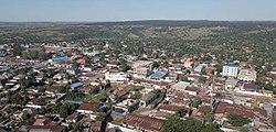 An overhead view of Tshikapa | |
 Tshikapa Location in the Democratic Republic of the Congo | |
| Coordinates: 6°25′S 20°48′E / 6.417°S 20.800°E | |
| Country | |
| Province | Kasai |
| City status | 2003 |
| Named for | Tshikapa River |
| Communes | Dibumba I, Dibumba II, Kanzala, Mabondo, Mbumba |
| Government | |
| • Mayor | Faustin Lumuluabo[1] |
| Area | |
| • Urban | 38 km2 (15 sq mi) |
| Elevation | 485 m (1,591 ft) |
| Population (2016 estimate)[2] | |
| • Urban | 732,000 |
| • Urban density | 19,000/km2 (50,000/sq mi) |
| • City | 267,462 |
| Time zone | UTC+2 (Central Africa Time) |
| Climate | Aw |
The city is served by the Tshikapa Airport. The diamond industry is the main form of income for the city[citation needed]. Despite this, it is poor and few of the roads are paved.[5]
History edit
Tshikapa was founded in the early 1900s by the American-Belgian mining consortium Forminière. The city grew rapidly as result of the First Congo War and now has a large population of internally displaced people. In April 2020, the 78-year old N1 Highway Bridge collapsed into the Kasai River causing significant interruptions to the regional transportation network and economy.[6]
Orientation edit
The city is set at the confluence of the Tshikapa and Kasai rivers and the meeting of the R706 and N01 highways. The city consists largely of 1- and 2-story mudbrick structures with metal roofing while the core of the city to the south of the river confluence has some structures with additional floors. A second bridge across the Kasai river to the north of the confluence was constructed in 2014.[7] There is a water treatment plant located in the center of the at the junction of the R706 and N01 highways. The Tshikapa Airport is located on the southern edge of the city center. The city has 67 primary and 36 secondary schools.

As of 2014, the city of Tshikapa has 3 hospitals, 15 hotels, six Regional Institutes, one court, one town hall, one central bank local office and an under-construction water treatment facility. Apart from Tshikapa, only two out of the six permanent markets were numbered[clarify] along the two primary roads in town. Most markets in the city are lacking basic business infrastructure in that the majority of products are displayed on the ground or in makeshift stalls. The road between Batshamba and Tshikapa was reconstructed between 2012 and 2019 providing safer access to the city.[8]
Tshikapa has two football stadiums, one located to the north of the Tshikapa River called Dibumba Stadium and one to the south of the river called Kanzala Stadium. The city is located 125 km to the north of the Angolan Border Crossing at Dundo. Kabodi is the town located nearest to the east, Sami to the south, Katshongo to the west and Mutena to the north.
Economy edit
The economic main activities are agriculture and diamond digging in Kasai Province. Tshikapa is the only town in the province with administrative services.[9] The city has limited access to electricity, gas and clean drinking water.
Climate edit
Tshikapa has a tropical savanna climate (Köppen Aw), fairly typical of the western Democratic Republic of Congo, with a dry season entered upon June and July and a lengthy though not intense wet season from September to May.
| Climate data for Tshikapa | |||||||||||||
|---|---|---|---|---|---|---|---|---|---|---|---|---|---|
| Month | Jan | Feb | Mar | Apr | May | Jun | Jul | Aug | Sep | Oct | Nov | Dec | Year |
| Mean daily maximum °C (°F) | 29 (85) |
29 (85) |
30 (86) |
30 (86) |
31 (87) |
31 (88) |
29 (85) |
30 (86) |
29 (85) |
29 (85) |
29 (85) |
29 (84) |
30 (86) |
| Mean daily minimum °C (°F) | 20 (68) |
20 (68) |
20 (68) |
20 (68) |
20 (68) |
18 (64) |
17 (63) |
19 (66) |
19 (67) |
20 (68) |
20 (68) |
20 (68) |
19 (67) |
| Average rainfall mm (inches) | 120 (4.7) |
110 (4.5) |
190 (7.3) |
150 (6.1) |
81 (3.2) |
13 (0.5) |
18 (0.7) |
51 (2) |
120 (4.6) |
150 (5.8) |
230 (9.2) |
210 (8.1) |
1,443 (56.7) |
| Source: Weatherbase [10] | |||||||||||||
References edit
- ^ Kavua, Hénock (25 January 2023). "Kasaï : les nouveaux animateurs de la petite territoriale officiellement installés". mediacongo.net (in French). Retrieved 26 January 2023.
- ^ PopulationStat.com Population of Tshikapa, city and urban area
- ^ "Google Earth".
- ^ Marcosson, Isaac F. (1921). An African Adventure. Curtis Publishing Company. p. 246.
- ^ Baker, Aryn (7 September 2015). "Blood Diamonds". Time. Archived from the original on August 29, 2015. Retrieved 13 September 2015.
- ^ "Réhabilitation du pont Kasaï : l'ACAJ recommande à l'Office des Routes de faire réaliser ces travaux dans le respect du cahier de charge". 21 April 2021.
- ^ "DRC - Upgrading of the Tshikapa – Mbuji Mayi Road, Tshikapa –Kamuesha Section (87 Km) and Rehabilitation of Rural Ancillary Agricultural Infrastructure - RAP Summary". 31 May 2019.
- ^ "Democratic Republic of Congo - Batshamba-Tshikapa Road Improvement Project: Loange Bridge - Lovua Bridge Section".
- ^ "DRC - Upgrading of the Tshikapa – Mbuji Mayi Road, Tshikapa –Kamuesha Section (87 Km) and Rehabilitation of Rural Ancillary Agricultural Infrastructure - RAP Summary". 31 May 2019.
- ^ "Weatherbase: Historical Weather for Tshikapa, Democratic Republic of the Congo". Weatherbase. 2011. Retrieved on November 24, 2011.
External links edit
- Map from Texas University library indicating Tshikapa's location
6°25′S 20°48′E / 6.417°S 20.800°E