


Summary
Turton Urban District was, from 1873 to 1974, a local government district centred on the historical area of Turton in the administrative county of Lancashire, England.
| Turton Urban District | |
|---|---|
 | |
| Area | |
| • 1911 | 17,335 acres (70.15 km2)[1] |
| • 1961 | 17,334 acres (70.15 km2)[1] |
| Area transferred | |
| • 1898 | Belmont, Bradshaw, Edgworth, Entwistle, Harwood, Longworth, and Quarlton from Bolton Rural District |
| Population | |
| • 1891 | 6,354 |
| • 1971 | 21,553 |
| History | |
| • Created | 1873 |
| • Abolished | 1974 |
| • Succeeded by | North Turton, South Turton |
| Status |
|
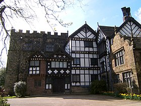
| • HQ | Turton Tower |
History edit
Background edit
Turton was a township and chapelry of the civil and ecclesiastical parish of Bolton le Moors in the Salford Hundred of Lancashire.[2] In 1837, Turton became part of the Bolton Poor Law Union which took responsibility for funding the Poor Law within that Union area.[3] In 1866, Turton was given the status of a civil parish.[4]
Formation edit
A resolution for the adoption of the Local Government Act 1858 was passed on 8 August 1872 by the owners and ratepayers of the township of Turton,[5] and the following year a local board was formed to govern the area.[6] After the Public Health Act 1875 was passed by Parliament in that year, Turton Local Board assumed extra duties as an urban sanitary district, although the Local Board's title did not change.[7]
Change edit
In 1895, following the implementation of the Local Government Act 1894, Turton Local Board was reconstituted as an elected urban district council of twenty-one members.[6] Four years later, under the Bolton, Turton and Westhoughton Extension Act 1898, Turton Urban District was greatly enlarged by the addition of the civil parishes of Belmont, Bradshaw, Harwood, Longworth, Entwistle, Edgworth and Quarlton from the former Bolton Rural District, which almost doubled the Urban District's population.[6] The Urban District Council had seven electoral wards: Chapeltown, Bromley Cross, Eagley, Egerton, Bradshaw, Edgworth, and Belmont wards, each represented by three councillors.[8] Following the death of Sir Lees Knowles, 1st Baronet, in 1929, his widow, Lady Nina Knowles, presented Turton Tower to the Urban District Council in 1930, which became the council's seat of local government. Between 1961 and 1971, Bradshaw ward was divided into Bradshaw North and Bradshaw South.[8]
Abolition edit
Under the Local Government Act 1972, Turton Urban District was abolished on 1 April 1974 and its former area was divided between two local authorities.[9] The larger rural area, North Turton, became a civil parish of the Borough of Blackburn in Lancashire.[9][10] The smaller urban area, South Turton, became an unparished area of the Metropolitan Borough of Bolton in Greater Manchester.[9]
Demography edit
|
|
| ||||||||||||||||||||||||||||||||||||
| Sources: Urban Sanitary District (USD) 1891.[11] Urban District (UD) 1901–1971.[8][12][13] | ||||||||||||||||||||||||||||||||||||||
Lists of office holders edit
Chairmen of Turton Local Board edit
| Chairmen of Turton Local Board | ||||
|---|---|---|---|---|
| Name | Party | Tenure | Notes | |
| Edmund Ashworth | Liberal | 1873–1880 |
||
| James Booth | — | 1880–1882 |
||
| Edmund Ashworth, jnr | — | 1882–1886 |
||
| Thomas Gustav Schwabe Garnett | Conservative | 1886–1889 |
Afterwards became Chairman of Turton Urban District Council (1895–1900) | |
| William Wallwork | — | 1889–1892 |
||
| Robert Ashworth | Independent | 1892–1895 |
Afterwards became Chairman of Turton Urban District Council (1908–1924) | |
| Source(s):[14] | ||||
Chairmen of Turton Urban District Council edit
| Chairmen of Turton Urban District Council | ||||
|---|---|---|---|---|
| Name | Party | Tenure | Notes | |
| Thomas Gustav Schwabe Garnett | Conservative | 1895–1900 |
Previously Chairman of Turton Local Board of Health (1886–1889) | |
| Samuel Isherwood | — | 1900–1901 |
||
| Thomas Hardcastle | — | 1901–1902 |
||
| Edward Deakin | — | 1902–1908 |
||
| Robert Ashworth | Independent | 1908–1924 |
Previously Chairman of Turton Local Board of Health (1892–1895) | |
| George Harry Ashworth | Independent | 1924–1926 |
1st term | |
| Ernest William Greg | — | 1926–1927 |
||
| Thomas Lomax | Conservative | 1928–1930 |
1st term | |
| Sydney Herbert Spring | Independent | 1930–1931 |
||
| Walter Harry Wadhams | Independent | 1931–1934 |
||
| Jethro Haslam | — | 1934 |
Died in office | |
| James Platt | Independent | 1934–1937 |
||
| Alfred Ruckman Hutchinson | Independent | 1937–1938 |
||
| Robert Catterall | Conservative | 1938–1939 |
1st term | |
| John William Rostron | — | 1939–1940 |
||
| George Harry Ashworth | Independent | 1940–1941 |
2nd term | |
| John Hamer | — | 1941–1942 |
||
| Richard Shelmerdine | Liberal | 1942–1943 |
||
| William Meredith | — | 1943–1944 |
||
| George Harry Ashworth | Independent | 1944–1945 |
3rd term | |
| Thomas Lomax | Conservative | 1945–1946 |
2nd term | |
| Harold Kirk | — | 1946–1947 |
1st term | |
| Samuel Benson | Conservative | 1947–1948 |
||
| William Knowles | — | 1948–1949 |
1st term | |
| West Scowcroft | Independent | 1949–1950 |
||
| Robinson Walsh | — | 1950–1951 |
||
| Francis William Stilwell | Conservative | 1951–1952 |
||
| Robert Catterall | Conservative | 1952–1953 |
2nd term | |
| Arthur Shelmerdine | Independent | 1953–1954 |
||
| Harold Kirk | — | 1954–1955 |
2nd term | |
| Robert Catterall | Conservative | 1955–1956 |
3rd term | |
| Andrew Thompson Jardine | Independent | 1956–1957 |
||
| William Knowles | — | 1957–1958 |
2nd term | |
| Harold Kirk | — | 1958–1959 |
3rd term | |
| Hilbre Henry Smith | Independent | 1959–1960 |
||
| Charles Halliday | Conservative | 1960–1961 |
||
| Hilda Gregory | Conservative | 1961–1962 |
||
| Herbert Bennett | Conservative | 1962–1963 |
1st term | |
| Michael Constantine Cort | Conservative | 1963–1964 |
||
| Herbert Carlisle Walsh | Conservative | 1964–1965 |
||
| David Dingwall | Labour | 1965–1966 |
||
| John Alston | Independent | 1966–1967 |
||
| Herbert Hutchinson | — | 1967–1968 |
||
| Joseph Jagger | Liberal | 1968–1969 |
||
| Philip Stefan Linney | Liberal | 1969–1970 |
||
| Leonard Ibbotson | Conservative | 1970–1971 |
||
| Keith Crook Richardson | Independent | 1971–1972 |
||
| Arthur Poulsom | Conservative | 1972–1973 |
||
| Herbert Bennett | Conservative | 1973–1974 |
2nd term | |
| Source(s):[14] | ||||
Notes edit
- ^ a b Great Britain Historical GIS Project. "Turton UD: Area (acres)". A Vision of Britain through Time. University of Portsmouth. Retrieved 27 July 2016.
- ^ Farrer, William; Brownbill, J., eds. (1911). "The parish of Bolton-le-Moors". A History of the County of Lancaster. Vol. 5. British History Online. pp. 235–243. Retrieved 27 July 2016.
{{cite book}}:|work=ignored (help) - ^ Higginbotham, Peter. "The Workhouse: Bolton, Lancashire". The Workhouse: The story of an institution... Retrieved 27 July 2016.
- ^ Great Britain Historical GIS Project. "Status details for Civil Parish". A Vision of Britain through Time. University of Portsmouth. Retrieved 27 July 2016.
- ^ "No. 23965". The London Gazette. 8 April 1873. p. 1874.
- ^ a b c Farrer, William; Brownbill, J., eds. (1911). "Townships: Turton". A History of the County of Lancaster. Vol. 5. British History Online. pp. 273–281. Retrieved 24 August 2010.
{{cite book}}:|work=ignored (help) - ^ Great Britain Historical GIS Project. "Turton USD: Relationships and changes". A Vision of Britain through Time. University of Portsmouth. Retrieved 27 July 2016.
- ^ a b c Tatton, Pauline. Local population statistics 1801–1986: abbreviated tables compiled from census statistics for Bolton. Bolton Libraries.
- ^ a b c "Greater Manchester Gazetteer". Greater Manchester County Record Office. Place names – T to W. Archived from the original on 18 July 2011. Retrieved 24 July 2016.
- ^ "North Turton Parish Council". Retrieved 27 July 2016.
- ^ Great Britain Historical GIS Project. "Turton USD: Males & Females". A Vision of Britain through Time. University of Portsmouth. Retrieved 15 July 2016.
- ^ Great Britain Historical GIS Project. "Turton UD: Total Population". A Vision of Britain through Time. University of Portsmouth. Retrieved 27 July 2016.
- ^ The 1939 population is estimated from the number of identity cards issued to the inhabitants of Turton in that year, which were required under the National Registration Act 1939. The 1941 census did not take place because of the Second World War.
- ^ a b Links in a Chain Project. "Turton 1873–1974". Links in a Chain. Retrieved 27 July 2016.
53°37′53″N 2°24′06″W / 53.6313°N 2.4018°W