


Summary
Ulvenhout is a village in the Dutch province of North Brabant. It is located in the municipality of Breda. The village was divided by the A58 motorway. The southern part belongs to the municipality of Alphen-Chaam and is called Ulvenhout AC.
Ulvenhout | |
|---|---|
Village | |
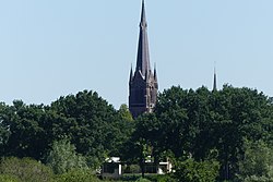 St Laurentius Church | |
 Flag  Coat of arms | |
 Ulvenhout  Ulvenhout | |
| Coordinates: 51°33′N 4°48′E / 51.550°N 4.800°E | |
| Country | Netherlands |
| Province | North Brabant |
| Municipality | Breda Alphen-Chaam |
| Area | |
| • Total | 12.45 km2 (4.81 sq mi) |
| Elevation | 5 m (16 ft) |
| Population (2021)[1] | |
| • Total | 5,220 |
| • Density | 420/km2 (1,100/sq mi) |
| Time zone | UTC+1 (CET) |
| • Summer (DST) | UTC+2 (CEST) |
| Postal code | 4851 & 4858[1] |
| Dialing code | 076 |
History edit
The village was first mentioned in 1274 as "Ulvenholti". The "hout" part means a deciduous forest. "Ulven" is suspected to be an extinct word for species of tree.[3] Ulvenhout was an agrarian settlement which started to develop in the 19th century along the Breda - Hoogstraten road.[4]
The Roman Catholic St Lawrence Church was built between 1903 and 1904 in Gothic Revival style. The tall tower has a constricted spire with corner turrets. It forms a collection with the nearby clergy house, a school, a 17th century gate post and a house near the church which belonged to the Buitenplaats' summer residence of Justinus van Nassau, the governor of Breda.[4]
Ulvenhout was home to 266 people in 1840. In 1942, it became a part of the municipality of Nieuw-Ginneken. In 1997, it was merged into Breda except for the part of the village in south of the A58 which was transferred to the municipality of Alphen-Chaam.[5]
Gallery edit
-
 Former shoemaker
 -
 School
 -
 Former town hall
 -
 Pancake house with cyclists


References edit
- ^ a b c "Kerncijfers wijken en buurten 2021". Central Bureau of Statistics. Retrieved 14 April 2022.
two entries
- ^ "Postcodetool for 4851AA". Actueel Hoogtebestand Nederland (in Dutch). Het Waterschapshuis. Retrieved 14 April 2022.
- ^ "Ulvenhout - (geografische naam)". Etymologiebank (in Dutch). Retrieved 14 April 2022.
- ^ a b Chris Kolman & Ronald Stenvert (1997). Ulvenhout (in Dutch). Zwolle: Waanders. ISBN 90 400 9945 6. Retrieved 14 April 2022.
- ^ "Ulvenhout". Plaatsengids (in Dutch). Retrieved 14 April 2022.
External links edit
 Media related to Ulvenhout at Wikimedia Commons