


Summary
Ushakov Island (Russian: Остров Ушакова, Ostrov Ushakova) is an isolated island located in the Arctic Ocean, Russian Federation.[1]
Russian: Остров Ушакова | |
|---|---|
 Ushakov island is practically covered with ice and snow the whole year round | |
 | |
 Ushakov Island | |
| Geography | |
| Location | Arctic Ocean |
| Coordinates | 80°48′N 79°29′E / 80.800°N 79.483°E |
| Area | 324 km2 (125 sq mi) |
| Length | 25.5 km (15.84 mi) |
| Width | 17.5 km (10.87 mi) |
| Highest elevation | 294 m (965 ft) |
| Highest point | Ice cap HP |
| Administration | |
| Demographics | |
| Population | 0 |
The average yearly precipitation ranges from 200 millimetres (8 inches) at a height of 50 metres (164 feet) and between 350 millimetres (14 inches) and 400 millimetres (16 inches) around the highest point of the island's ice cap.[2]
Geography edit
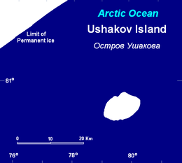
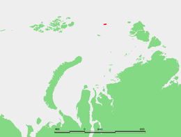
Ushakov Island is located close to the region of permanent sea ice midway between Franz Josef Land and Severnaya Zemlya, at the northern limit of the Kara Sea.[3] This island lies close to the limit of permanent ice; it is desolate and subject to severe Arctic storms. Its total area is 324 square kilometres (125 square miles).[4] This island belongs to the Taymyrsky Dolgano-Nenetsky District of the Krasnoyarsk Krai administrative division of Russia. Owing to its extreme northerly location, the sea surrounding Ushakov Island is covered with pack ice in the winter and is full of ice floes during the summer. The closest land is Vize Island 140 kilometres (87 miles) further south.[5]
Ice cap edit
Ushakov Island is covered by an ice cap.[6] The highest point of this glacial feature is 294 m (965 ft).[7] The rocky ground below the icemass is flat and part of it lies below sea level. The edges of the ice cap form 20 m (66 ft) to 30 m (98 ft) high icy cliffs along the shore.[2] The surface of the ice cap has become 2 square kilometres (1 square mile) smaller between 1950 and 2000, but the ice volume has grown from 35 cubic kilometres (8 cubic miles) to 38 cubic kilometres (9 cubic miles). The average thickness of the ice having increased from 107 m (351 ft) to 118 m (387 ft).[4]
Climate edit
Ushakov island has an ice cap climate (EF), bordering on a tundra climate (ET; average high in July is above freezing, meaning some snow can melt), owing to its location at 81 N and ~20 miles from the limit of permanent sea ice. Summers are very cold and dry, while winters are extremely frigid and virtually without precipitation.
| Climate data for Ushakov Island (1981-2010 normals, extremes 1973-2020) | |||||||||||||
|---|---|---|---|---|---|---|---|---|---|---|---|---|---|
| Month | Jan | Feb | Mar | Apr | May | Jun | Jul | Aug | Sep | Oct | Nov | Dec | Year |
| Record high °C (°F) | −2.4 (27.7) |
−0.8 (30.6) |
−0.8 (30.6) |
0.3 (32.5) |
2.0 (35.6) |
4.0 (39.2) |
5.0 (41.0) |
5.2 (41.4) |
3.7 (38.7) |
0.8 (33.4) |
−1.0 (30.2) |
−2.0 (28.4) |
5.2 (41.4) |
| Mean daily maximum °C (°F) | −23.1 (−9.6) |
−23.6 (−10.5) |
−24.1 (−11.4) |
−18.9 (−2.0) |
−8.7 (16.3) |
−1.0 (30.2) |
0.6 (33.1) |
0.0 (32.0) |
−3.6 (25.5) |
−10.8 (12.6) |
−19.2 (−2.6) |
−23.4 (−10.1) |
−13.2 (8.2) |
| Daily mean °C (°F) | −26.2 (−15.2) |
−26.4 (−15.5) |
−26.8 (−16.2) |
−21.6 (−6.9) |
−10.6 (12.9) |
−2.2 (28.0) |
−0.3 (31.5) |
−1.1 (30.0) |
−5.4 (22.3) |
−13.5 (7.7) |
−21.9 (−7.4) |
−26.1 (−15.0) |
−15.4 (4.3) |
| Mean daily minimum °C (°F) | −29.2 (−20.6) |
−29.1 (−20.4) |
−29.5 (−21.1) |
−24.3 (−11.7) |
−12.4 (9.7) |
−3.4 (25.9) |
−1.1 (30.0) |
−2.2 (28.0) |
−7.1 (19.2) |
−16.1 (3.0) |
−24.6 (−12.3) |
−28.8 (−19.8) |
−17.6 (0.3) |
| Record low °C (°F) | −43.1 (−45.6) |
−47.0 (−52.6) |
−43.5 (−46.3) |
−42.2 (−44.0) |
−24.6 (−12.3) |
−13.3 (8.1) |
−7.3 (18.9) |
−12.0 (10.4) |
−25.0 (−13.0) |
−37.0 (−34.6) |
−37.0 (−34.6) |
−44.7 (−48.5) |
−47.0 (−52.6) |
| Average precipitation mm (inches) | 5.9 (0.23) |
3.1 (0.12) |
4.9 (0.19) |
9.7 (0.38) |
7.6 (0.30) |
4.7 (0.19) |
22.8 (0.90) |
17.3 (0.68) |
8.3 (0.33) |
18.3 (0.72) |
3.7 (0.15) |
2.5 (0.10) |
107.4 (4.23) |
| Average precipitation days (≥ 1 mm) | 1.36 | 0.77 | 1.44 | 1.60 | 2.25 | 1.46 | 1.56 | 2.45 | 2.69 | 2.46 | 1.26 | 0.51 | 19.60 |
| Source 1: Météo climat stats[8] | |||||||||||||
| Source 2: Météo Climat [9] | |||||||||||||
History edit
This island was the last piece of undiscovered territory in the Soviet Arctic. It was finally located in 1935 when the few remaining unexplored areas in the northern Kara Sea were surveyed by Soviet hydrographic and oceanographic operations on icebreakers to study the sea and ice.
The expedition that discovered the island was led by polar explorer, cartographer and oceanographer Georgiy Alekseevich Ushakov aboard Icebreaker Sadko, after whom the island was named. The first wintering in Ushakov Island was undertaken in 1954–55 and a polar station was established in 1954. This was abandoned during the 1980s and when an expedition visited the island in 2001, they found two small buildings partly sunken into the ice.[10]
See also edit
References edit
- ^ Summary of the Arctic Archipelagos and Islands. Scott Polar Research Institute, University of Cambridge.
- ^ a b Andrey F. Glazovskiy: Russian Arctic, Chapter 2.7 in: Jacek Jania, Jon Ove Hagen (Ed.): Mass Balance of Arctic Glaciers (PDF; 132 kB), IASC Report No. 5, Sosnowiec-Oslo 1996.
- ^ "Ostrov Ushakova". Mapcarta. Retrieved 9 November 2016.
- ^ a b Aleksey I. Sharov, Roland Pail, Roland Perko, Daniel Rieser, Florian Heuberger, Christoph Gisinger: Variations of the Arctic Ice-Snow Cover in Nonhomogeneous Geopotential (PDF; 660 kB). In: Proc. ESA Living Planet Symposium, Bergen, Norway 28 June – 2 July 2010 (ESA SP-686, December 2010)
- ^ Google Earth
- ^ Arctic Glaciers; Ushakov Island
- ^ V. V. Bogorodsky, C. R. Bentley, P. E. Gudmandsen: Radioglaciology, D. Reidel, Dordrecht 1985, ISBN 978-94-010-8830-5, doi:10.1007/978-94-009-5275-1, S. 5
- ^ "Moyennes 1981-2010 Russie" (in French). Retrieved 16 March 2022.
- ^ "Météo Climat stats for Ile Ouchakov". Météo Climat. Retrieved 16 March 2022.
- ^ полярная станция Остров Ушакова (in Russian). Archived. Retrieved 3 May 2018.
External links edit
- The route over the drifting ice of Kara Sea from Frantz-Josef Land Archipelago to Ushakov Island