
KNOWPIA
WELCOME TO KNOWPIA

Utena District Municipality 
Summary
Utena District Municipality is one of 60 municipalities in Lithuania.
Utena District Municipality
Utenos rajono savivaldybė | |
|---|---|
 Coat of arms | |
 Location of Utena district municipality within Lithuania | |
 Map of Utena district municipality | |
| Country | |
| Ethnographic region | Aukštaitija |
| County | |
| Capital | Utena (town) |
| Elderships | 10 |
| Area | |
| • Total | 1,229 km2 (475 sq mi) |
| • Rank | 29th |
| Population (2021[1]) | |
| • Total | 37,509 |
| • Rank | 18-19th |
| • Density | 31/km2 (79/sq mi) |
| • Rank | 19th |
| Time zone | UTC+2 (EET) |
| • Summer (DST) | UTC+3 (EEST) |
| Telephone code | 389 |
| Major settlements | |
| Website | www |
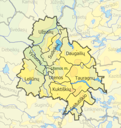
Structure edit
District structure:
- 1 city – Utena;
- 8 towns – Daugailiai, Kuktiškės, Leliūnai, Saldutiškis, Sudeikiai, Tauragnai, Užpaliai and Vyžuonos;
- 592 villages.
Population of largest Molėtai District Municipality elderships (2001):
Nature and geography edit
-

-
 Puntukas of Biliakiemis
 -
 Indrajai


References edit
- ^ "Gyventojai gyvenamosiose vietovėse (Residents in residential areas)". Archived from the original (XLSX) on 2022-09-30. Retrieved 2024-01-17.
55°31′12″N 25°38′49″E / 55.52000°N 25.64694°E