
KNOWPIA
WELCOME TO KNOWPIA

Val-de-la-Haye 
Summary
Val-de-la-Haye (French pronunciation: [val də la ɛ]) is a commune in the Seine-Maritime department in the Normandy region in north-western France.
Val-de-la-Haye | |
|---|---|
 Coat of arms | |
Location of Val-de-la-Haye .mw-parser-output .locmap .od{position:absolute}.mw-parser-output .locmap .id{position:absolute;line-height:0}.mw-parser-output .locmap .l0{font-size:0;position:absolute}.mw-parser-output .locmap .pv{line-height:110%;position:absolute;text-align:center}.mw-parser-output .locmap .pl{line-height:110%;position:absolute;top:-0.75em;text-align:right}.mw-parser-output .locmap .pr{line-height:110%;position:absolute;top:-0.75em;text-align:left}.mw-parser-output .locmap .pv>div{display:inline;padding:1px}.mw-parser-output .locmap .pl>div{display:inline;padding:1px;float:right}.mw-parser-output .locmap .pr>div{display:inline;padding:1px;float:left}html.skin-theme-clientpref-night .mw-parser-output .od,html.skin-theme-clientpref-night .mw-parser-output .od .pv>div,html.skin-theme-clientpref-night .mw-parser-output .od .pl>div,html.skin-theme-clientpref-night .mw-parser-output .od .pr>div{background:#000;color:#fff}html.skin-theme-clientpref-night .mw-parser-output .locmap{filter:grayscale(0.6)}@media(prefers-color-scheme:dark){html.skin-theme-clientpref-os .mw-parser-output .locmap{filter:grayscale(0.6)}html.skin-theme-clientpref-os .mw-parser-output .od,html.skin-theme-clientpref-os .mw-parser-output .od .pv>div,html.skin-theme-clientpref-os .mw-parser-output .od .pl>div,html.skin-theme-clientpref-os .mw-parser-output .od .pr>div{background:#000;color:#fff}}  Val-de-la-Haye  Val-de-la-Haye | |
| Coordinates: 49°22′41″N 1°00′07″E / 49.378°N 1.002°E | |
| Country | France |
| Region | Normandy |
| Department | Seine-Maritime |
| Arrondissement | Rouen |
| Canton | Canteleu |
| Intercommunality | Métropole Rouen Normandie |
| Government | |
| • Mayor (2020–2026) | Pascal Delaporte[1] |
| Area 1 | 10.16 km2 (3.92 sq mi) |
| Population (2021)[2] | 708 |
| • Density | 70/km2 (180/sq mi) |
| Time zone | UTC+01:00 (CET) |
| • Summer (DST) | UTC+02:00 (CEST) |
| INSEE/Postal code | 76717 /76380 |
| Elevation | 2–119 m (6.6–390.4 ft) (avg. 15 m or 49 ft) |
| 1 French Land Register data, which excludes lakes, ponds, glaciers > 1 km2 (0.386 sq mi or 247 acres) and river estuaries. | |
Geography edit
A forestry and light industrial village situated by the banks of the Seine, some 6 miles (9.7 km) southwest of Rouen on the D 51 road. A car ferry connects with the commune of Petit-Couronne on the opposite bank.
Heraldry edit
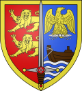 |
The arms of the commune of Val-de-la-Haye are blazoned : Per pale 1: gules, 2 demi-leopards issuant from the line of division and 2: azure, a boat proper issuant from sinister sailing on a base barry wavy azure and argent, and in chief an imperial French eagle Or grasping a lightning bolt argent; over the per pale line of division, a sword throughout argent garnished proper, the guard has argent blobs at the tips, and is charged with a lozenge argent charged with a Maltese cross; and the pommel is charged with a torteau [gules]; the entire shield fimbriated Or.
|
Population edit
|
| ||||||||||||||||||||||||||||||||||||||||||||||||||||||||||||||||||||||||||||||||||||||||||||||||||||||||||||||||||
| Source: EHESS[3] and INSEE (1968-2017)[4] | |||||||||||||||||||||||||||||||||||||||||||||||||||||||||||||||||||||||||||||||||||||||||||||||||||||||||||||||||||
Places of interest edit
- The church of St. Jean-Baptiste, dating from the twentieth century.
- Vestiges of the thirteenth-century Templars' Sainte-Vaubourg commandery.
- A commemorative stone column topped with a bronze eagle, built in 1846.
See also edit
References edit
- ^ "Répertoire national des élus: les maires". data.gouv.fr, Plateforme ouverte des données publiques françaises (in French). 9 August 2021.
- ^ "Populations légales 2021". The National Institute of Statistics and Economic Studies. 28 December 2023.
- ^ Des villages de Cassini aux communes d'aujourd'hui: Commune data sheet Val-de-la-Haye, EHESS (in French).
- ^ Population en historique depuis 1968, INSEE
External links edit
Wikimedia Commons has media related to Val-de-la-Haye.
- Official town website (in French)