


Summary
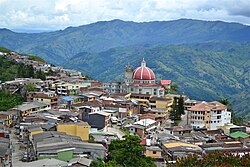
Valdivia is a town and municipality in Antioquia Department, Colombia. Part of the subregion of Northern Antioquia, its population was 11,511 at the 2018 census.
Valdivia, Antioquia | |
|---|---|
Municipality and town | |
 Valdivia, Antioquia | |
 Flag | |
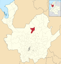 Location of the municipality and town of Valdivia, Antioquia in the Antioquia Department of Colombia | |
 Valdivia, Antioquia Location in Colombia | |
| Coordinates: 7°17′20.4″N 75°23′52.8″W / 7.289000°N 75.398000°W | |
| Country | |
| Department | |
| Subregion | Northern |
| Elevation | 1,100 m (3,600 ft) |
| Population (Census 2018[1]) | |
| • Total | 11,511 |
| Time zone | UTC-5 (Colombia Standard Time) |
History edit
Valdivia was inhabited by the Nutabes people upon the arrival of the Spanish colonists. In 1849 Spanish Pedro Vasquez acquired the land and cultivated the area, bringing labourers from other regions of Antioquia, that eventually began exploring and exploiting other land nearby. On February 5, 1892, became a corregimiento part of the municipality of Yarumal. Braulio Berrio was named its first Corregidor. In 1912 the Assembly of Antioquia segregated Valdivia from Yarumal assigned more land to its territory from other municipalities and made it a municipality.
Climate edit
Valdivia has an elevation moderated tropical rainforest climate (Af). It has very heavy rainfall year-round.
| Climate data for Valdivia | |||||||||||||
|---|---|---|---|---|---|---|---|---|---|---|---|---|---|
| Month | Jan | Feb | Mar | Apr | May | Jun | Jul | Aug | Sep | Oct | Nov | Dec | Year |
| Mean daily maximum °C (°F) | 24.3 (75.7) |
24.7 (76.5) |
25.1 (77.2) |
25.3 (77.5) |
25.6 (78.1) |
25.6 (78.1) |
25.7 (78.3) |
25.7 (78.3) |
25.5 (77.9) |
25.2 (77.4) |
24.8 (76.6) |
24.3 (75.7) |
25.1 (77.3) |
| Daily mean °C (°F) | 21.2 (70.2) |
21.4 (70.5) |
21.7 (71.1) |
21.8 (71.2) |
22.0 (71.6) |
22.0 (71.6) |
21.9 (71.4) |
22.0 (71.6) |
21.7 (71.1) |
21.5 (70.7) |
21.4 (70.5) |
21.2 (70.2) |
21.7 (71.0) |
| Mean daily minimum °C (°F) | 18.6 (65.5) |
18.6 (65.5) |
18.8 (65.8) |
19.1 (66.4) |
19.2 (66.6) |
19.1 (66.4) |
18.8 (65.8) |
18.8 (65.8) |
18.8 (65.8) |
18.8 (65.8) |
19.0 (66.2) |
18.9 (66.0) |
18.9 (66.0) |
| Average rainfall mm (inches) | 332.8 (13.10) |
414.7 (16.33) |
410.7 (16.17) |
356.2 (14.02) |
392.6 (15.46) |
408.2 (16.07) |
346.0 (13.62) |
405.1 (15.95) |
497.1 (19.57) |
399.1 (15.71) |
466.3 (18.36) |
436.9 (17.20) |
4,865.7 (191.56) |
| Average rainy days | 15 | 15 | 17 | 22 | 26 | 25 | 26 | 25 | 25 | 27 | 24 | 18 | 265 |
| Average relative humidity (%) | 89 | 89 | 89 | 90 | 90 | 90 | 89 | 89 | 89 | 90 | 91 | 90 | 90 |
| Mean monthly sunshine hours | 124.0 | 101.6 | 93.0 | 84.0 | 102.3 | 114.0 | 145.7 | 139.5 | 114.0 | 105.4 | 120.0 | 120.9 | 1,364.4 |
| Mean daily sunshine hours | 4.0 | 3.6 | 3.0 | 2.8 | 3.3 | 3.8 | 4.7 | 4.5 | 3.8 | 3.4 | 4.0 | 3.9 | 3.7 |
| Source: [2] | |||||||||||||
References edit
- (in Spanish) University of Antioquia Library; Valdivia, Antioquia
7°17′20″N 75°23′53″W / 7.289°N 75.398°W