


Summary
Varennes-sur-Allier (French pronunciation: [vaʁɛn syʁ alje], literally Varennes on Allier; Occitan: Varenas) is a commune in the Allier department in Auvergne-Rhône-Alpes in central France.
Varennes-sur-Allier | |
|---|---|
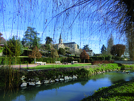 A view within Varennes-sur-Allier | |
 Coat of arms | |
Location of Varennes-sur-Allier .mw-parser-output .locmap .od{position:absolute}.mw-parser-output .locmap .id{position:absolute;line-height:0}.mw-parser-output .locmap .l0{font-size:0;position:absolute}.mw-parser-output .locmap .pv{line-height:110%;position:absolute;text-align:center}.mw-parser-output .locmap .pl{line-height:110%;position:absolute;top:-0.75em;text-align:right}.mw-parser-output .locmap .pr{line-height:110%;position:absolute;top:-0.75em;text-align:left}.mw-parser-output .locmap .pv>div{display:inline;padding:1px}.mw-parser-output .locmap .pl>div{display:inline;padding:1px;float:right}.mw-parser-output .locmap .pr>div{display:inline;padding:1px;float:left}html.skin-theme-clientpref-night .mw-parser-output .od,html.skin-theme-clientpref-night .mw-parser-output .od .pv>div,html.skin-theme-clientpref-night .mw-parser-output .od .pl>div,html.skin-theme-clientpref-night .mw-parser-output .od .pr>div{background:#000;color:#fff}html.skin-theme-clientpref-night .mw-parser-output .locmap{filter:grayscale(0.6)}@media(prefers-color-scheme:dark){html.skin-theme-clientpref-os .mw-parser-output .locmap{filter:grayscale(0.6)}html.skin-theme-clientpref-os .mw-parser-output .od,html.skin-theme-clientpref-os .mw-parser-output .od .pv>div,html.skin-theme-clientpref-os .mw-parser-output .od .pl>div,html.skin-theme-clientpref-os .mw-parser-output .od .pr>div{background:#000;color:#fff}}  Varennes-sur-Allier  Varennes-sur-Allier | |
| Coordinates: 46°18′47″N 3°24′08″E / 46.3130°N 3.4022°E | |
| Country | France |
| Region | Auvergne-Rhône-Alpes |
| Department | Allier |
| Arrondissement | Vichy |
| Canton | Saint-Pourçain-sur-Sioule |
| Intercommunality | Entr'Allier Besbre et Loire |
| Government | |
| • Mayor (2020–2026) | Roger Litaudon[1] |
| Area 1 | 24.1 km2 (9.3 sq mi) |
| Population (2021)[2] | 3,609 |
| • Density | 150/km2 (390/sq mi) |
| Time zone | UTC+01:00 (CET) |
| • Summer (DST) | UTC+02:00 (CEST) |
| INSEE/Postal code | 03298 /03150 |
| Elevation | 228–292 m (748–958 ft) (avg. 248 m or 814 ft) |
| 1 French Land Register data, which excludes lakes, ponds, glaciers > 1 km2 (0.386 sq mi or 247 acres) and river estuaries. | |
History edit
In 52 BC during the Gallic Wars lived by Julius Caesar, Vercingetorix crossed the river Elave (moderne Loire), and started marching up and down the banks of the river Loire, mirroring Caesar's movements and destroying all the bridges to keep him from crossing, the purpose presumably being to destroy part of his force as he attempted to cross. Realizing Vercingetorix's plan, Caesar resolved to trick him and cross under his very nose.[3]
Caesar one night camped near the town of Varennes,[3] where there had previously been a bridge before Vercingetorix had destroyed it. That night, he divided his force into two parts, one part being 2/3 of the force, the other being 1/3 of the force. He ordered the larger force to march in 6 corps, as if it were in fact the full corps.[3] He then ordered it to continue its march south. Vercingetorix, duped, took the bait and followed this part of the force.
Caesar, with the two legions still present at Varennes, speedily rebuilt the bridge that had been present there. He then sent for the other force, which during that next day stole a march on Vercingetorix, and completed a junction with the original force, and crossed the rebuilt bridge.[3] Realizing that he had been duped, Vercingetorix set out south, to beat Caesar to Gergovia.
Population edit
| Year | Pop. | ±% p.a. |
|---|---|---|
| 1968 | 4,712 | — |
| 1975 | 4,907 | +0.58% |
| 1982 | 4,751 | −0.46% |
| 1990 | 4,413 | −0.92% |
| 1999 | 4,072 | −0.89% |
| 2007 | 3,814 | −0.81% |
| 2012 | 3,542 | −1.47% |
| 2017 | 3,561 | +0.11% |
| Source: INSEE[4] | ||
See also edit
References edit
- ^ "Répertoire national des élus: les maires" (in French). data.gouv.fr, Plateforme ouverte des données publiques françaises. 13 September 2022.
- ^ "Populations légales 2021". The National Institute of Statistics and Economic Studies. 28 December 2023.
- ^ a b c d Dodge, Theodore Ayrault (19 July 2006). Cæsar – a history of the art of war among the Romans down to the end of the Roman Empire ... – Theodore Ayrault Dodge – Google eBookstore. Retrieved 11 November 2011.
- ^ Population en historique depuis 1968, INSEE