


Summary
Vega Baja (Spanish pronunciation: [ˈbeɣa ˈβaxa]) is a town and municipality located on the coast of north central Puerto Rico. It is north of Morovis, east of Manatí, and west of Vega Alta. Vega Baja is spread over 14 barrios. The population of the municipality was 54,414 at the 2020 census.[2] It is part of the San Juan–Caguas–Guaynabo metropolitan statistical area.
Vega Baja
Municipio Autónomo de Vega Baja | |
|---|---|
City and municipality | |
 Ciudad del Melao Melao welcome sign in Vega Baja | |
 Flag  Coat of arms | |
| Nickname: "Ciudad del Melao Melao" | |
| Anthem: "A Vega Baja" | |
 Map of Puerto Rico highlighting Vega Baja Municipality | |
| Coordinates: 18°26′46″N 66°23′15″W / 18.44611°N 66.38750°W | |
| Sovereign state | |
| Commonwealth | |
| Founded | October 7, 1776 |
| Barrios | |
| Government | |
| • Mayor | Marcos Cruz Molina (Partido Popular Democrático) |
| • Senatorial dist. | 3 - Arecibo |
| • Representative dist. | 12 |
| Area | |
| • Total | 55.71 sq mi (144.28 km2) |
| • Land | 47 sq mi (122 km2) |
| • Water | 8.60 sq mi (22.28 km2) |
| Population (2020)[1] | |
| • Total | 54,414 |
| • Rank | 13th in Puerto Rico |
| • Density | 980/sq mi (380/km2) |
| Demonym | Vegabajeños |
| Time zone | UTC-4 (AST) |
| ZIP Codes | 00693, 00694 |
| Area code | 787/939 |
| Major routes | |
| Website | www |
History edit
The name Vega Baja in Spanish means 'lower valley' (Vega Alta meaning 'upper valley'). Historians believe that the name Vega Baja comes from La Vega. Vega is a surname of one of the families involved in the foundation of Vega Baja. It is also believed that the name comes from the region of Spain La Vega Baja del Segura. Additionally, in Caribbean Spanish, a vega is also a tobacco plantation.[3]
Although is generally believed that Vega Baja was founded in 1776, after the division of Vega Alta from La Vega (modern day Vega Alta) historians have verified that it was many years later when it was officially recognized by the Spanish government. The foundation day is October 7, and it is also the day of commemorating the Virgin of the Rosary. Vega Baja was originally known as Vega-baxa del Naranjal de Nuestra Señora del Rosario (Vega Baja of the Orange Grove of Our Lady of the Rosary).
Cibuco is one of the rivers that goes through Vega Baja, and is a variation of the name Sebuco, who was a chief or Cacique Taíno of the region. These small tribes of Taínos were known to settle in the vicinity of the rivers. Although the Cibuco River is prone to floods due to heavy seasonal rains, the benefits provided to the land by the river are numerous.
Taino rock carvings have been found on some of the exposed reefs in the vicinity of the Cibuco River. Among these carvings is one depicting a face and others shaped as fish. They are an indication that these reefs were frequented for spear fishing and perhaps other day-to-day activities. Other places like Carmelita, Maisabel, Cueva Maldita and Paso del Indio are known as archaeological sites where the aborigines established their communities.
Drug trafficking has been an issue in Vega Baja for many years[4] and in early 1990, $43 million dollars in cash was found buried in plastic barrels, thought to have been deposited by drug smugglers for later retrieval. The sudden wealth of a few Vega Baja residents attracted attention and prompted an investigation by FBI and local police.[5] By May 1990, the FBI had traced $11 million and seized and confiscated property and goods purchased with the money thought to belong to drug lord Ramon Torres Gonzalez.[6]
On September 20, 2017 Hurricane Maria struck the island of Puerto Rico. With an area of about 121.4 square kilometres (46.9 sq mi) Vega Baja is a municipality on the north coast with some barrios on the coast and others in more mountainous areas. With an estimated population of 53,674 (2016, Census estimates) when Hurricane Maria struck, 48.5% were below poverty and 21.8% were people over the age of 60. The hurricane triggered numerous landslides in the municipality. Rivers were breached causing flooding of low-lying areas, and infrastructure including homes were destroyed. A tributary of the Cibuco River rose immediately putting 100 people's lives at risk. Many of those residents took refuge on roofs or sought out small boats to navigate the flooded waters and to help remove people who were trapped on roofs or inside residences. Then municipal staff picked people up in buses and took them to the shelter at the Lino Padrón school, where the electric generator nor school cistern worked. Telecommunications systems were destroyed causing state and municipal rescue officers to have to rely on radio communication signals, which were limited to a radius of a few miles. Radio signals did not reach Vega Baja and news, such as the fact that a curfew had been declared, only spread by word of mouth. The mayor, who lost his home, said the storm surge and hurricane winds destroyed most of the structures in Cerro Gordo, a coastal sector. The urban, downtown areas were impassable due to the large number of downed trees and power lines. The Cibuco River roe above PR-2 highway, preventing the passage to the adjoining town/ municipality of Vega Alta and heading west, a stretch could be covered with extreme difficulty, until it was also blocked with the rising of the Río Grande de Manatí. The mayor stated, “We don't know what happened on the mountain. We have not been able to get there yet,” and “The destruction is so great. I don't know how to explain seeing the despair of a mother or an elderly person right now. It is not easy what we are living.”[7][8][9]
Geography edit

Vega Baja is located on the northern coast.[10] The municipality is located along the Northern Karst region of Puerto Rico, and the town is located on the Northern Plains.
Barrios edit

Like all municipalities of Puerto Rico, Vega Baja is subdivided into barrios. The municipal buildings, central square and large Catholic church are located in a barrio called "Pueblo" (barrio-pueblo on the US Census).[11][12][13] Note: While the US Census and the PR GIS data, indicate there are 14 barrios in Vega Baja, the Vega Baja government page seems to exclude Vega Baja barrio-pueblo in its list of barrios.[14]
Sectors edit
Barrios (which are, in contemporary times, roughly comparable to minor civil divisions)[15] and subbarrios,[16] are further subdivided into smaller areas called sectores (sectors in English). The types of sectores may vary, from normally sector to urbanización to reparto to barriada to residencial, among others.[17][18][19]
Special Communities edit
Comunidades Especiales de Puerto Rico (Special Communities of Puerto Rico) are marginalized communities whose citizens are experiencing a certain amount of social exclusion. A map shows these communities occur in nearly every municipality of the commonwealth. Of the 742 places that were on the list in 2014, the following barrios, communities, sectors, or neighborhoods were in Vega Baja: Alto de Cuba, Callejón Pérez and Sector El Hoyo in Barrio Algarrobo, Guarico Viejo, and La Trocha-Río Abajo.[20][21]
Demographics edit
| Census | Pop. | Note | %± |
|---|---|---|---|
| 1900 | 10,305 | — | |
| 1910 | 12,831 | 24.5% | |
| 1920 | 15,756 | 22.8% | |
| 1930 | 20,406 | 29.5% | |
| 1940 | 23,105 | 13.2% | |
| 1950 | 28,925 | 25.2% | |
| 1960 | 30,189 | 4.4% | |
| 1970 | 35,327 | 17.0% | |
| 1980 | 47,115 | 33.4% | |
| 1990 | 55,997 | 18.9% | |
| 2000 | 61,929 | 10.6% | |
| 2010 | 59,662 | −3.7% | |
| 2020 | 54,414 | −8.8% | |
| U.S. Decennial Census[22] 1899 (shown as 1900)[23] 1910-1930[24] 1930-1950[25] 1960-2000[26] 2010[13] 2020[1] | |||
Puerto Rico was ceded by Spain in the aftermath of the Spanish–American War under the terms of the Treaty of Paris of 1898 and became a territory of the United States. In 1899, the United States conducted its first census of Puerto Rico finding that the population of Vega Baja was 10,305.
| Vega Baja - 2020 census[28] | ||
|---|---|---|
| Race | Population | % |
| White alone | 10,042 | 18.5 |
| Black or Afro-Puerto Rican | 3,491 | 6.4 |
| American Indian/Alaska Native | 460 | 0.8 |
| Asian alone | 28 | 0.1 |
| Native Hawaiian and other Pacific Islander alone | 9 | 0.0 |
| Some other race alone | 13,783 | 25.3 |
| Two or More Races alone | 26,601 | 48.9 |
Tourism edit
Landmarks and places of interest edit
There are 14 beaches in Vega Baja.[29] Some main attractions of Vega Baja include:
- Casa Alcaldía (the historic city hall)
- Casa Alonso Museum
- Casa Portela Museum
- Cibuco Swamp
- El Trece Recreational Area
- Vega Baja House of Culture and Tourism
- Man of the Sugar Cane Monument
- Melao Melao Artisan Center
- Migrants Square
- Museo del Salon de la Fama del Deporte Vega Baja Melao Melao
- Puerto Nuevo Beach and its recreational area[30]
- José Francisco Náter Square (main town square or plaza)
- Teatro América
- Teatro Fénix
- Tortuguero Lagoon
- Tortuguero Recreational Area
- Trinitarias Park
Economy edit

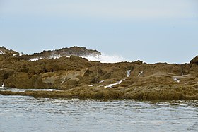
The abundant fertility of its soil has meant Vega Baja has much agricultural and farming land. In addition, Vega Baja has one of the most visited beaches of the northern coastline, Puerto Nuevo Beach (officially Mar Bella Beach). This beach attracts thousands of beachgoers annually, making it a center for local tourism, especially during the hot summer months.[30] It boasts a natural rock formation of enormous proportions both in height and length colloquially named La Peña. This rock feature shelters the beach portion from the open seas just behind it. During rough marine conditions, the rock feature protects beachgoers, while the spectacle of waves crashing from behind and cascading down its face can be appreciated in the relative safety of the beach.[31]
Agriculture edit
- Pineapple, cattle feed (hay). In decades past, the land portion situated between the neighborhood of Monte Carlo and the neighborhood of Los Naranjos, was the site for the cultivation of sugar cane.
- Dairy farming[32]
Industry edit
- Clothing, leather articles; electrical and electronic equipment, machinery
- Medical, and pharmaceutical.
Culture edit
Festivals and events edit
Vega Baja celebrates its patron saint festival in October. The Fiestas Patronales de Nuestra Virgen del Rosario is a religious and cultural celebration that generally features parades, games, artisans, amusement rides, regional food, and live entertainment.[10][33]
Other festivals and events celebrated in Vega Baja include:
- Three Kings Festival – January
- Triathlon – March
- Annual Tournament of Champions – June
- San Juan Night – June
- Virgen del Carmen Festival – July
- Beach Festival at Mar Bella - July
- Socio-Cultural Fair – May
- Melao Melao Festival – October
- Christmas Festival – December
Government edit
Vega Baja, like all municipalities of Puerto Rico, elect a mayor every four years to administer the city. The educator Marcos Cruz Molina is the mayor since 2013 and Rafael “Piro” Martinez is the President of the Municipal Legislature.
The city belongs to the Puerto Rico Senatorial district III, which is represented by two senators. In 2012, José "Joito" Pérez and Ángel "Chayanne" Martínez were elected as District Senators. Rafael (Tatito) Hernández is the Eleventh District Representative and Hector Torres the Twelve District Representative at the House of Representatives of Puerto Rico.
Transportation edit
There are 23 bridges in Vega Baja.[34]
Notable people edit
- Bad Bunny – Platinum rapper, singer, record producer, actor, and professional wrestler.
- Chicky Starr – Professional wrestler and manager in the World Wrestling Council (WWC) and the International Wrestling Association (IWA)
- Ivan Rodriguez – a.k.a. “Pudge” was widely considered the best catcher of his generation, MLB AL MVP, perennial all star and gold glover. Hall of Fame baseball player who played mostly for the Texas Rangers
- Juan Gonzalez – Two time AL MVP, 3 time Allstar, Multiple time AL HR leader, Home run derby winner, MLB RBI leader and in 1998 he was owner of the second most RBIs by all star break ever (101). He played mostly for the Texas Rangers.
Symbols edit
The municipio has an official flag and coat of arms.[35]
Flag edit
Vega Baja's flag consists of a yellow cloth crossed by a green band. The band relates to the fertile valley and the river.[36]
Coat of arms edit
The Vega Baja coat of arms has a v-shaped green band with overlapping roses in silver and three oranges trees, with gold fruit. At the top part is a five-tower crown, silver, black and green. The main colors of the shield; green and gold are used traditionally in civic, scholastic and sports activities. The crown five tower indicates that the town holds the rank of "Villa" by royal decree.[36]
Anthem edit
The anthem of Vega Baja is "A Vega Baja" with lyrics as written in 1974 by Adrián Santos Tirado and music by Roberto Sierra.
Education edit

The following schools are in Vega Baja:[37]
- Agapito Rosario Rosario Grades: K - 5
- Angel Sandin Martinez Grades: 6 - 8
- Centro De Adiestramiento
- Juan Quirindongo Morell (Superior) Grades: 9 - 12
- Lino Padro Rivera Grades: 9 - 12
- Manuel Martinez Davila Grades: K - 8
- Nueva Brigida Alvarez Rodriguez Grades: K - 12
- Rafael Hernandez Grades: K - 5
- San Vicente Grades: K - 5
- Su Almirante Norte Grades: Pre-K - 8
Higher education edit
- Caribbean University-Vega Baja Private Not-for-profit 4-year or above
Private schools edit
- Mech-Tech College
Gallery edit
-
 Elkhorn coral near the coast of Vega Baja.
 -
 View of Vega Baja in Pugnado Adentro.
 -

-
 Limestone rock in Mar Bella Beach (Puerto Nuevo Beach).
 -
 Vega Baja license plate in Altamonte Springs, Florida.


See also edit
- List of Puerto Ricans
- History of Puerto Rico
- Did you know-Puerto Rico?
References edit
- ^ a b "PUERTO RICO: 2020 Census". The United States Census Bureau. Retrieved August 25, 2021.
- ^ "Puerto Rico Population Declined 11.8% From 2010 to 2020". Census.gov. Retrieved April 11, 2022.
- ^ "Vega". February 12, 2022.
- ^ "58 Indicted For Drug Trafficking in La Trocha Ward, Vega Baja". DEA.gov. November 25, 2008. Retrieved May 16, 2021.
- ^ Lemoyne, James (April 18, 1990). "Talk of a Puerto Rico Town: Buried Treasure, No Kidding". NYT. Archived from the original on August 15, 2017. Retrieved February 24, 2019.
- ^ "FBI Seizes Houses, Cars, Trucks Bought with Buried Drug Treasure". AP NEWS. May 11, 1990. Retrieved May 16, 2021.
- ^ "Preliminary Locations of Landslide Impacts from Hurricane Maria, Puerto Rico". USGS Landslide Hazards Program. USGS. Archived from the original on March 3, 2019. Retrieved March 3, 2019.
- ^ "Preliminary Locations of Landslide Impacts from Hurricane Maria, Puerto Rico" (PDF). USGS Landslide Hazards Program. USGS. Archived (PDF) from the original on March 3, 2019. Retrieved March 3, 2019.
- ^ "El Nuevo Día: María, un nombre que no vamos a olvidar. Desalojos de emergencia por inundaciones en Vega Baja" [Maria, a name we will never forget. Flood emergency evacuations in Vega Baja]. El Nuevo Día (in Spanish). June 13, 2019. Retrieved September 11, 2022.
- ^ a b "Vega Baja Municipality". enciclopediapr.org. Fundación Puertorriqueña de las Humanidades (FPH). Archived from the original on May 9, 2019. Retrieved March 20, 2019.
- ^ Picó, Rafael; Buitrago de Santiago, Zayda; Berrios, Hector H. (1969). Nueva geografía de Puerto Rico: física, económica, y social, por Rafael Picó. Con la colaboración de Zayda Buitrago de Santiago y Héctor H. Berrios. San Juan Editorial Universitaria, Universidad de Puerto Rico,1969. Archived from the original on December 26, 2018. Retrieved December 30, 2018.
- ^ Gwillim Law (May 20, 2015). Administrative Subdivisions of Countries: A Comprehensive World Reference, 1900 through 1998. McFarland. p. 300. ISBN 978-1-4766-0447-3. Retrieved December 25, 2018.
- ^ a b Puerto Rico:2010:population and housing unit counts.pdf (PDF). U.S. Dept. of Commerce Economics and Statistics Administration U.S. Census Bureau. 2010. Archived (PDF) from the original on February 20, 2017. Retrieved December 30, 2018.
- ^ "Libro de Pintar "Te invito a conocer la ciudad de Vega Baja"". Municipio Autónomo de Vega Baja (in Spanish). August 29, 2014. Retrieved January 23, 2023.
- ^ "US Census Barrio-Pueblo definition". factfinder.com. US Census. Archived from the original on May 13, 2017. Retrieved January 5, 2019.
- ^ "P.L. 94-171 VTD/SLD Reference Map (2010 Census): Vega Baja Municipio, PR" (PDF). www2.census.gov. U.S. DEPARTMENT OF COMMERCE Economics and Statistics Administration U.S. Census Bureau. Archived (PDF) from the original on August 22, 2020. Retrieved August 22, 2020.
- ^ "Agencia: Oficina del Coordinador General para el Financiamiento Socioeconómico y la Autogestión (Proposed 2016 Budget)". Puerto Rico Budgets (in Spanish). Archived from the original on June 28, 2019. Retrieved June 28, 2019.
- ^ Rivera Quintero, Marcia (2014), El vuelo de la esperanza: Proyecto de las Comunidades Especiales Puerto Rico, 1997-2004 (first ed.), San Juan, Puerto Rico Fundación Sila M. Calderón, ISBN 978-0-9820806-1-0
- ^ "Leyes del 2001". Lex Juris Puerto Rico (in Spanish). Archived from the original on September 14, 2018. Retrieved June 24, 2020.
- ^ Rivera Quintero, Marcia (2014), El vuelo de la esperanza:Proyecto de las Comunidades Especiales Puerto Rico, 1997-2004 (Primera edición ed.), San Juan, Puerto Rico Fundación Sila M. Calderón, p. 273, ISBN 978-0-9820806-1-0
- ^ "Comunidades Especiales de Puerto Rico" (in Spanish). August 8, 2011. Archived from the original on June 24, 2019. Retrieved June 24, 2019.
- ^ "U.S. Decennial Census". United States Census Bureau. Archived from the original on February 13, 2020. Retrieved September 21, 2017.
- ^ "Report of the Census of Porto Rico 1899". War Department Office Director Census of Porto Rico. Archived from the original on July 16, 2017. Retrieved September 21, 2017.
- ^ "Table 3-Population of Municipalities: 1930 1920 and 1910" (PDF). United States Census Bureau. Archived (PDF) from the original on August 17, 2017. Retrieved September 21, 2017.
- ^ "Table 4-Area and Population of Municipalities Urban and Rural: 1930 to 1950" (PDF). United States Census Bureau. Archived (PDF) from the original on August 30, 2015. Retrieved September 21, 2014.
- ^ "Table 2 Population and Housing Units: 1960 to 2000" (PDF). United States Census Bureau. Archived (PDF) from the original on July 24, 2017. Retrieved September 21, 2017.
- ^ "Population and Housing Unit Estimates". United States Census Bureau. Archived from the original on December 27, 1996. Retrieved September 21, 2017.
- ^ "PUERTO RICO: 2020 Census". U.S. Census Bureau. August 25, 2021. Retrieved December 27, 2023.
- ^ "Las 1,200 playas de Puerto Rico [The 1200 beaches of Puerto Rico]". Primera Hora (in Spanish). April 14, 2017. Archived from the original on December 12, 2019. Retrieved December 12, 2019.
- ^ a b "Vega Baja busca una Alianza Público Privada para la casona del balneario". El Nuevo Dia (in Spanish). February 22, 2019. Archived from the original on February 23, 2019. Retrieved March 15, 2019.
- ^ "¿Te bañarías en esta playa con un rompeolas natural que parece un tsunami? (VIDEO)". Diario Correo. January 6, 2018. Archived from the original on October 22, 2019. Retrieved October 22, 2019.
- ^ "Martinez family holds onto dairy heritage". Archived from the original on August 22, 2020. Retrieved August 3, 2020.
- ^ "Puerto Rico Festivales, Eventos y Actividades en Puerto Rico". Puerto Rico Hoteles y Paradores (in Spanish). Archived from the original on February 26, 2020. Retrieved July 17, 2020.
- ^ "Vega Baja Bridges". National Bridge Inventory Data. US Dept. of Transportation. Archived from the original on February 21, 2019. Retrieved February 20, 2019.
- ^ "Ley Núm. 70 de 2006 -Ley para disponer la oficialidad de la bandera y el escudo de los setenta y ocho (78) municipios". LexJuris de Puerto Rico (in Spanish). Retrieved June 15, 2021.
- ^ a b "VEGA BAJA". LexJuris (Leyes y Jurisprudencia) de Puerto Rico (in Spanish). February 19, 2020. Archived from the original on February 19, 2020. Retrieved September 17, 2020.
- ^ "Search For Schools and Colleges". National Center for Education Statistics (NCES) Home Page, a part of the U.S. Department of Education. Retrieved October 6, 2020.
Further reading edit
- Mapa de municipios y barrios - Vega Baja - Memoria Núm. 36 (PDF). University of Puerto Rico: Estado Libre Asociado de Puerto Rico, Oficina del Gobernador, Junta de Planificacion, Santurce, Puerto Rico. 1955.
External links edit
- Enciclopedia Vegabajena
- Official Municipal Government Website
- Archivo del Diario Vegabajeño de Puerto Rico Segunda Etapa de Diciembre 2012 a Octubre 2016
- (sin título)
- U.S. Census Bureau QuickFacts: Vega Baja Municipio, Puerto Rico
- Vega Baja Municipality on Facebook