KNOWPIA
WELCOME TO KNOWPIA

Vele Orjule 
Summary
Vele Orjule is an uninhabited Croatian island in the Adriatic Sea located southeast of Lošinj. Its area is 1.06 km2 (0.41 sq mi).[1]
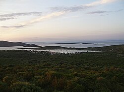
 Vele Orjule (left) and Male Orjule (right) from Sveti Petar | |
.mw-parser-output .locmap .od{position:absolute}.mw-parser-output .locmap .id{position:absolute;line-height:0}.mw-parser-output .locmap .l0{font-size:0;position:absolute}.mw-parser-output .locmap .pv{line-height:110%;position:absolute;text-align:center}.mw-parser-output .locmap .pl{line-height:110%;position:absolute;top:-0.75em;text-align:right}.mw-parser-output .locmap .pr{line-height:110%;position:absolute;top:-0.75em;text-align:left}.mw-parser-output .locmap .pv>div{display:inline;padding:1px}.mw-parser-output .locmap .pl>div{display:inline;padding:1px;float:right}.mw-parser-output .locmap .pr>div{display:inline;padding:1px;float:left}html.skin-theme-clientpref-night .mw-parser-output .od,html.skin-theme-clientpref-night .mw-parser-output .od .pv>div,html.skin-theme-clientpref-night .mw-parser-output .od .pl>div,html.skin-theme-clientpref-night .mw-parser-output .od .pr>div{background:#000;color:#fff}html.skin-theme-clientpref-night .mw-parser-output .locmap{filter:grayscale(0.6)}@media(prefers-color-scheme:dark){html.skin-theme-clientpref-os .mw-parser-output .locmap{filter:grayscale(0.6)}html.skin-theme-clientpref-os .mw-parser-output .od,html.skin-theme-clientpref-os .mw-parser-output .od .pv>div,html.skin-theme-clientpref-os .mw-parser-output .od .pl>div,html.skin-theme-clientpref-os .mw-parser-output .od .pr>div{background:#000;color:#fff}} Vele Orjule | |
| Geography | |
|---|---|
| Location | Adriatic Sea |
| Coordinates | 44°30′00″N 14°33′21″E / 44.50000°N 14.55583°E |
| Archipelago | Cres-Lošinj |
| Area | 1.06 km2 (0.41 sq mi) |
| Highest elevation | 30 m (100 ft) |
| Highest point | Pristavnica |
| Administration | |
Croatia | |
| Demographics | |
| Population | 0 |
West of this island is good and sheltered anchorage.
In 1996, the statue of Croatian Apoxyomenos was discovered there.