


Summary
Verberie (French pronunciation: [vɛʁbəʁi]) is a commune in the Oise department in northern France.[3]
Verberie | |
|---|---|
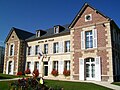
 The chateau of Aramont, in Verberie | |
 Coat of arms | |
Location of Verberie .mw-parser-output .locmap .od{position:absolute}.mw-parser-output .locmap .id{position:absolute;line-height:0}.mw-parser-output .locmap .l0{font-size:0;position:absolute}.mw-parser-output .locmap .pv{line-height:110%;position:absolute;text-align:center}.mw-parser-output .locmap .pl{line-height:110%;position:absolute;top:-0.75em;text-align:right}.mw-parser-output .locmap .pr{line-height:110%;position:absolute;top:-0.75em;text-align:left}.mw-parser-output .locmap .pv>div{display:inline;padding:1px}.mw-parser-output .locmap .pl>div{display:inline;padding:1px;float:right}.mw-parser-output .locmap .pr>div{display:inline;padding:1px;float:left}html.skin-theme-clientpref-night .mw-parser-output .od,html.skin-theme-clientpref-night .mw-parser-output .od .pv>div,html.skin-theme-clientpref-night .mw-parser-output .od .pl>div,html.skin-theme-clientpref-night .mw-parser-output .od .pr>div{background:#000;color:#fff}html.skin-theme-clientpref-night .mw-parser-output .locmap{filter:grayscale(0.6)}@media(prefers-color-scheme:dark){html.skin-theme-clientpref-os .mw-parser-output .locmap{filter:grayscale(0.6)}html.skin-theme-clientpref-os .mw-parser-output .od,html.skin-theme-clientpref-os .mw-parser-output .od .pv>div,html.skin-theme-clientpref-os .mw-parser-output .od .pl>div,html.skin-theme-clientpref-os .mw-parser-output .od .pr>div{background:#000;color:#fff}}  Verberie  Verberie | |
| Coordinates: 49°18′40″N 2°43′56″E / 49.3111°N 2.7322°E | |
| Country | France |
| Region | Hauts-de-France |
| Department | Oise |
| Arrondissement | Senlis |
| Canton | Crépy-en-Valois |
| Intercommunality | CA Région de Compiègne et Basse Automne |
| Government | |
| • Mayor (2020–2026) | Michel Arnould[1] |
| Area 1 | 15.05 km2 (5.81 sq mi) |
| Population (2021)[2] | 3,819 |
| • Density | 250/km2 (660/sq mi) |
| Time zone | UTC+01:00 (CET) |
| • Summer (DST) | UTC+02:00 (CEST) |
| INSEE/Postal code | 60667 /60410 |
| Elevation | 30–125 m (98–410 ft) (avg. 33 m or 108 ft) |
| 1 French Land Register data, which excludes lakes, ponds, glaciers > 1 km2 (0.386 sq mi or 247 acres) and river estuaries. | |
It lies 7 miles (11 km) southwest of Compiègne on the main road to Senlis and Paris. The railway station is on the line from Compiègne to Crépy-en-Valois.
History edit
Verberie was the site of an Iron Age aristocratic Gallic farm, during the La Tène period.[4]
On 1 October 856 Judith, the daughter of Charles the Bald, King of West Francia, married Æthelwulf, King of Wessex at the royal palace of Verberie.[5]
During the First World War it was the scene of fighting on 1 September 1914, and in 1918. The village has several war cemeteries including the Verberie French National Cemetery which contains the graves of 3,221 French soldiers (of whom 2,339 are unidentified), 52 servicemen from the United Kingdom, and one Canadian cavalryman.
Population edit
| Year | Pop. | ±% p.a. |
|---|---|---|
| 1968 | 2,511 | — |
| 1975 | 2,512 | +0.01% |
| 1982 | 2,293 | −1.29% |
| 1990 | 2,627 | +1.71% |
| 1999 | 3,283 | +2.51% |
| 2007 | 3,466 | +0.68% |
| 2012 | 4,062 | +3.22% |
| 2017 | 3,848 | −1.08% |
| Source: INSEE[6] | ||
The inhabitants are known as Sautriauts in French.[7]
Personalities edit
It was the birthplace of author and feminist Juliette Adam.
Gallery edit
-
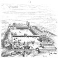 Palais carolingien
 -
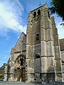 Saint-Pierre-et-Saint-Paul church
 -
 Saint-Germain Manor
 -
 Town hall
 -

-
 LGV Nord viaduct


Iron Age Gallic farm edit
-
 Iron Age Gallic farm model
 -

-


See also edit
References edit
- ^ "Répertoire national des élus: les maires" (in French). data.gouv.fr, Plateforme ouverte des données publiques françaises. 13 September 2022.
- ^ "Populations légales 2021". The National Institute of Statistics and Economic Studies. 28 December 2023.
- ^ INSEE commune file
- ^ "Le site archéologique – Mairie de Verberie". Mairie de Verberie.
- ^ Nelson, Janet, trans. and ed. (1991). The Annals of St-Bertin. Manchester, UK: Manchester University Press. p. 83. ISBN 978-0-7190-3426-8.
{{cite book}}:|first=has generic name (help)CS1 maint: multiple names: authors list (link) - ^ Population en historique depuis 1968, INSEE
- ^ Oise, habitants.fr