
KNOWPIA
WELCOME TO KNOWPIA

Verchin 
Summary
Verchin (French pronunciation: [vɛʁʃɛ̃]) is a commune in the Pas-de-Calais department in the Hauts-de-France region of France.[3]
Verchin | |
|---|---|
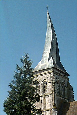
 The church of Verchin | |
 Coat of arms | |
Location of Verchin .mw-parser-output .locmap .od{position:absolute}.mw-parser-output .locmap .id{position:absolute;line-height:0}.mw-parser-output .locmap .l0{font-size:0;position:absolute}.mw-parser-output .locmap .pv{line-height:110%;position:absolute;text-align:center}.mw-parser-output .locmap .pl{line-height:110%;position:absolute;top:-0.75em;text-align:right}.mw-parser-output .locmap .pr{line-height:110%;position:absolute;top:-0.75em;text-align:left}.mw-parser-output .locmap .pv>div{display:inline;padding:1px}.mw-parser-output .locmap .pl>div{display:inline;padding:1px;float:right}.mw-parser-output .locmap .pr>div{display:inline;padding:1px;float:left}html.skin-theme-clientpref-night .mw-parser-output .od,html.skin-theme-clientpref-night .mw-parser-output .od .pv>div,html.skin-theme-clientpref-night .mw-parser-output .od .pl>div,html.skin-theme-clientpref-night .mw-parser-output .od .pr>div{background:#000;color:#fff}html.skin-theme-clientpref-night .mw-parser-output .locmap{filter:grayscale(0.6)}@media(prefers-color-scheme:dark){html.skin-theme-clientpref-os .mw-parser-output .locmap{filter:grayscale(0.6)}html.skin-theme-clientpref-os .mw-parser-output .od,html.skin-theme-clientpref-os .mw-parser-output .od .pv>div,html.skin-theme-clientpref-os .mw-parser-output .od .pl>div,html.skin-theme-clientpref-os .mw-parser-output .od .pr>div{background:#000;color:#fff}}  Verchin  Verchin | |
| Coordinates: 50°29′43″N 2°11′07″E / 50.4953°N 2.1853°E | |
| Country | France |
| Region | Hauts-de-France |
| Department | Pas-de-Calais |
| Arrondissement | Montreuil |
| Canton | Fruges |
| Intercommunality | CC Haut Pays du Montreuillois |
| Government | |
| • Mayor (2020–2026) | Florence Pruvost[1] |
| Area 1 | 10.68 km2 (4.12 sq mi) |
| Population (2021)[2] | 233 |
| • Density | 22/km2 (57/sq mi) |
| Time zone | UTC+01:00 (CET) |
| • Summer (DST) | UTC+02:00 (CEST) |
| INSEE/Postal code | 62843 /62310 |
| Elevation | 88–171 m (289–561 ft) (avg. 102 m or 335 ft) |
| 1 French Land Register data, which excludes lakes, ponds, glaciers > 1 km2 (0.386 sq mi or 247 acres) and river estuaries. | |
Geography edit
Verchin is located 20 miles (32 km) east of Montreuil-sur-Mer on the D93 road.
Population edit
The inhabitants are called Verchinois.
| Year | Pop. | ±% p.a. |
|---|---|---|
| 1968 | 303 | — |
| 1975 | 276 | −1.32% |
| 1982 | 250 | −1.40% |
| 1990 | 220 | −1.59% |
| 1999 | 220 | +0.00% |
| 2007 | 199 | −1.25% |
| 2012 | 233 | +3.20% |
| 2017 | 241 | +0.68% |
| Source: INSEE[4] | ||
Places of interest edit
- The Château, dating from the sixteenth century
- The seventeenth century presbytery.
- The flamboyant gothic church of St. Omer, dating from the seventeenth century, with its twisted spire, caused by the use of unseasoned timber.
See also edit
References edit
- ^ "Répertoire national des élus: les maires". data.gouv.fr, Plateforme ouverte des données publiques françaises (in French). 9 August 2021.
- ^ "Populations légales 2021". The National Institute of Statistics and Economic Studies. 28 December 2023.
- ^ INSEE commune file
- ^ Population en historique depuis 1968, INSEE
Wikimedia Commons has media related to Verchin.