
KNOWPIA
WELCOME TO KNOWPIA

Verosvres 
Summary
Verosvres (French pronunciation: [veʁovʁ]) is a commune in the Saône-et-Loire department in the region of Bourgogne-Franche-Comté in eastern France.
Verosvres | |
|---|---|
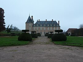 Chateau of Terreau | |
Location of Verosvres .mw-parser-output .locmap .od{position:absolute}.mw-parser-output .locmap .id{position:absolute;line-height:0}.mw-parser-output .locmap .l0{font-size:0;position:absolute}.mw-parser-output .locmap .pv{line-height:110%;position:absolute;text-align:center}.mw-parser-output .locmap .pl{line-height:110%;position:absolute;top:-0.75em;text-align:right}.mw-parser-output .locmap .pr{line-height:110%;position:absolute;top:-0.75em;text-align:left}.mw-parser-output .locmap .pv>div{display:inline;padding:1px}.mw-parser-output .locmap .pl>div{display:inline;padding:1px;float:right}.mw-parser-output .locmap .pr>div{display:inline;padding:1px;float:left}html.skin-theme-clientpref-night .mw-parser-output .od,html.skin-theme-clientpref-night .mw-parser-output .od .pv>div,html.skin-theme-clientpref-night .mw-parser-output .od .pl>div,html.skin-theme-clientpref-night .mw-parser-output .od .pr>div{background:#000;color:#fff}html.skin-theme-clientpref-night .mw-parser-output .locmap{filter:grayscale(0.6)}@media(prefers-color-scheme:dark){html.skin-theme-clientpref-os .mw-parser-output .locmap{filter:grayscale(0.6)}html.skin-theme-clientpref-os .mw-parser-output .od,html.skin-theme-clientpref-os .mw-parser-output .od .pv>div,html.skin-theme-clientpref-os .mw-parser-output .od .pl>div,html.skin-theme-clientpref-os .mw-parser-output .od .pr>div{background:#000;color:#fff}}  Verosvres  Verosvres | |
| Coordinates: 46°24′05″N 4°26′38″E / 46.4014°N 4.4439°E | |
| Country | France |
| Region | Bourgogne-Franche-Comté |
| Department | Saône-et-Loire |
| Arrondissement | Mâcon |
| Canton | La Chapelle-de-Guinchay |
| Government | |
| • Mayor (2020–2026) | Éric Martin[1] |
| Area 1 | 22.96 km2 (8.86 sq mi) |
| Population (2021)[2] | 432 |
| • Density | 19/km2 (49/sq mi) |
| Time zone | UTC+01:00 (CET) |
| • Summer (DST) | UTC+02:00 (CEST) |
| INSEE/Postal code | 71571 /71220 |
| Elevation | 326–596 m (1,070–1,955 ft) (avg. 386 m or 1,266 ft) |
| 1 French Land Register data, which excludes lakes, ponds, glaciers > 1 km2 (0.386 sq mi or 247 acres) and river estuaries. | |
History edit
The name Verosvres is derived from the Gallic word Verobriga, vero meaning "true" or "good" and briga meaning "fortress": thus giving "Good castle".[3]: 9
In 1920, the town of Verosvres formed "an agglomeration of about eighty houses, including one for the post office and telegraph." The town was then served by a railway line, now defunct, which connected Paray-le-Monial to Mâcon, and stopped at a station called "Les Terreaux — Verosvres".[3]: 6
Notable people edit
- Verosvres is the birthplace of Saint Margaret Mary Alacoque, who first inspired devotion to the Sacred Heart of Jesus in the Roman Catholic Church.
- Pierre Albuisson (born in 1952), French postage stamp engraver and designer, presides the Art du timbre gravé association whose headquarters are located in Verosvres.
See also edit
References edit
- ^ "Répertoire national des élus: les maires" (in French). data.gouv.fr, Plateforme ouverte des données publiques françaises. 13 September 2022.
- ^ "Populations légales 2021". The National Institute of Statistics and Economic Studies. 28 December 2023.
- ^ a b Villars, Lucien (2005). Monographie de la commune de Verosvres. The Storybook-Lorisse.
Wikimedia Commons has media related to Verosvres.