
KNOWPIA
WELCOME TO KNOWPIA

Versols-et-Lapeyre 
Summary
Versols-et-Lapeyre (French pronunciation: [vɛʁsɔl e lapɛʁ]; Occitan: Verzòls e La Pèira) is a commune in the Aveyron department in southern France.
Versols-et-Lapeyre | |
|---|---|
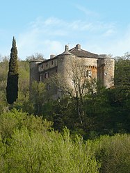 Montalègre chateau | |
Location of Versols-et-Lapeyre .mw-parser-output .locmap .od{position:absolute}.mw-parser-output .locmap .id{position:absolute;line-height:0}.mw-parser-output .locmap .l0{font-size:0;position:absolute}.mw-parser-output .locmap .pv{line-height:110%;position:absolute;text-align:center}.mw-parser-output .locmap .pl{line-height:110%;position:absolute;top:-0.75em;text-align:right}.mw-parser-output .locmap .pr{line-height:110%;position:absolute;top:-0.75em;text-align:left}.mw-parser-output .locmap .pv>div{display:inline;padding:1px}.mw-parser-output .locmap .pl>div{display:inline;padding:1px;float:right}.mw-parser-output .locmap .pr>div{display:inline;padding:1px;float:left}html.skin-theme-clientpref-night .mw-parser-output .od,html.skin-theme-clientpref-night .mw-parser-output .od .pv>div,html.skin-theme-clientpref-night .mw-parser-output .od .pl>div,html.skin-theme-clientpref-night .mw-parser-output .od .pr>div{background:#000;color:#fff}html.skin-theme-clientpref-night .mw-parser-output .locmap{filter:grayscale(0.6)}@media(prefers-color-scheme:dark){html.skin-theme-clientpref-os .mw-parser-output .locmap{filter:grayscale(0.6)}html.skin-theme-clientpref-os .mw-parser-output .od,html.skin-theme-clientpref-os .mw-parser-output .od .pv>div,html.skin-theme-clientpref-os .mw-parser-output .od .pl>div,html.skin-theme-clientpref-os .mw-parser-output .od .pr>div{background:#000;color:#fff}}  Versols-et-Lapeyre  Versols-et-Lapeyre | |
| Coordinates: 43°54′N 2°57′E / 43.90°N 2.95°E | |
| Country | France |
| Region | Occitania |
| Department | Aveyron |
| Arrondissement | Millau |
| Canton | Saint-Affrique |
| Intercommunality | Saint Affricain, Roquefort, Sept Vallons |
| Government | |
| • Mayor (2020–2026) | Marc Desoteux[1] |
| Area 1 | 27.95 km2 (10.79 sq mi) |
| Population (2021)[2] | 418 |
| • Density | 15/km2 (39/sq mi) |
| Time zone | UTC+01:00 (CET) |
| • Summer (DST) | UTC+02:00 (CEST) |
| INSEE/Postal code | 12292 /12400 |
| Elevation | 264–766 m (866–2,513 ft) (avg. 380 m or 1,250 ft) |
| 1 French Land Register data, which excludes lakes, ponds, glaciers > 1 km2 (0.386 sq mi or 247 acres) and river estuaries. | |
Geography edit
The hamlets of Versols and Lapeyre lie on the right bank of the Sorgues, which flows northwest through the middle of the commune.
Population edit
| Year | Pop. | ±% |
|---|---|---|
| 1962 | 374 | — |
| 1968 | 310 | −17.1% |
| 1975 | 260 | −16.1% |
| 1982 | 307 | +18.1% |
| 1990 | 340 | +10.7% |
| 1999 | 353 | +3.8% |
| 2008 | 435 | +23.2% |
See also edit
References edit
- ^ "Répertoire national des élus: les maires". data.gouv.fr, Plateforme ouverte des données publiques françaises (in French). 9 August 2021.
- ^ "Populations légales 2021". The National Institute of Statistics and Economic Studies. 28 December 2023.
Wikimedia Commons has media related to Versols-et-Lapeyre.