
KNOWPIA
WELCOME TO KNOWPIA

Verton 
Summary
Verton (French pronunciation: [vɛʁtɔ̃]) is a commune in the Pas-de-Calais department in the Hauts-de-France region of France.[3]
Verton | |
|---|---|
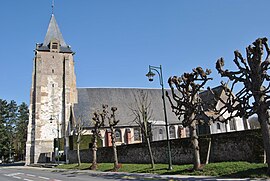 The St. Michel Church in Verton | |
 Coat of arms | |
Location of Verton .mw-parser-output .locmap .od{position:absolute}.mw-parser-output .locmap .id{position:absolute;line-height:0}.mw-parser-output .locmap .l0{font-size:0;position:absolute}.mw-parser-output .locmap .pv{line-height:110%;position:absolute;text-align:center}.mw-parser-output .locmap .pl{line-height:110%;position:absolute;top:-0.75em;text-align:right}.mw-parser-output .locmap .pr{line-height:110%;position:absolute;top:-0.75em;text-align:left}.mw-parser-output .locmap .pv>div{display:inline;padding:1px}.mw-parser-output .locmap .pl>div{display:inline;padding:1px;float:right}.mw-parser-output .locmap .pr>div{display:inline;padding:1px;float:left}html.skin-theme-clientpref-night .mw-parser-output .od,html.skin-theme-clientpref-night .mw-parser-output .od .pv>div,html.skin-theme-clientpref-night .mw-parser-output .od .pl>div,html.skin-theme-clientpref-night .mw-parser-output .od .pr>div{background:#000;color:#fff}html.skin-theme-clientpref-night .mw-parser-output .locmap{filter:grayscale(0.6)}@media(prefers-color-scheme:dark){html.skin-theme-clientpref-os .mw-parser-output .locmap{filter:grayscale(0.6)}html.skin-theme-clientpref-os .mw-parser-output .od,html.skin-theme-clientpref-os .mw-parser-output .od .pv>div,html.skin-theme-clientpref-os .mw-parser-output .od .pl>div,html.skin-theme-clientpref-os .mw-parser-output .od .pr>div{background:#000;color:#fff}}  Verton  Verton | |
| Coordinates: 50°24′10″N 1°39′00″E / 50.4028°N 1.65°E | |
| Country | France |
| Region | Hauts-de-France |
| Department | Pas-de-Calais |
| Arrondissement | Montreuil |
| Canton | Berck |
| Intercommunality | CA Deux Baies en Montreuillois |
| Government | |
| • Mayor (2020–2026) | Joël Lemaire[1] |
| Area 1 | 11.06 km2 (4.27 sq mi) |
| Population (2021)[2] | 2,537 |
| • Density | 230/km2 (590/sq mi) |
| Time zone | UTC+01:00 (CET) |
| • Summer (DST) | UTC+02:00 (CEST) |
| INSEE/Postal code | 62849 /62180 |
| Elevation | 2–53 m (6.6–173.9 ft) (avg. 12 m or 39 ft) |
| 1 French Land Register data, which excludes lakes, ponds, glaciers > 1 km2 (0.386 sq mi or 247 acres) and river estuaries. | |
Geography edit
Verton is located 6 miles (9 km) southwest of Montreuil-sur-Mer at the D143 and D303 road junction, and 3 miles (5 km) from the coast, near the estuary of the Authie.
Population edit
| Year | Pop. | ±% p.a. |
|---|---|---|
| 1968 | 746 | — |
| 1975 | 954 | +3.58% |
| 1982 | 1,570 | +7.38% |
| 1990 | 1,947 | +2.73% |
| 1999 | 2,123 | +0.97% |
| 2007 | 2,272 | +0.85% |
| 2012 | 2,257 | −0.13% |
| 2017 | 2,425 | +1.45% |
| Source: INSEE[4] | ||
Places of interest edit
See also edit
References edit
- ^ "Répertoire national des élus: les maires" (in French). data.gouv.fr, Plateforme ouverte des données publiques françaises. 13 September 2022.
- ^ "Populations légales 2021". The National Institute of Statistics and Economic Studies. 28 December 2023.
- ^ INSEE commune file
- ^ Population en historique depuis 1968, INSEE
Wikimedia Commons has media related to Verton.