
KNOWPIA
WELCOME TO KNOWPIA

Victoria Island (California) 
Summary
Victoria Island is an island in the Sacramento-San Joaquin River Delta, 20 km (12 mi) southwest of Stockton.[1] The 7,200-acre (2,900 ha) island is bounded on the north by North Victoria Canal, on the northeast by Middle River, on the southeast by Victoria Canal, and on the south- and southwest Old River. It is crossed by California State Route 4.[2] It is in San Joaquin County, and managed by Reclamation District 2040.[3] It appears on 1913 and 1952 United States Geological Survey maps of the area.[4][5]
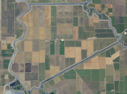 USGS aerial imagery of Victoria Island | |
 Victoria Island  Victoria Island  Victoria Island | |
| Geography | |
|---|---|
| Location | Northern California |
| Coordinates | 37°53′24″N 121°32′05″W / 37.889925°N 121.534672°W |
| Adjacent to | Sacramento-San Joaquin River Delta |
| Area | 7,200 acres (2,900 ha) |
| Administration | |
| State | |
| County | San Joaquin |
Buried impact structure edit
Oil exploration led to the discovery of a possible buried impact structure in the sediments under the island. It was named the Victoria Island Structure after the island.[6][7]
See also edit
References edit
- ^ "Victoria Island". Geographic Names Information System. United States Geological Survey, United States Department of the Interior.
- ^ https://www.google.com/maps/place/Victoria+Island/@37.8996282,-121.5586859,13.41z/data=!4m5!3m4!1s0x809004aa4e357c97:0x3e325cb8da5b40c5!8m2!3d37.8899253!4d-121.5346722 Google Maps shows it as a cross with route 4
- ^ "Municipal Service Review: Selected San Joaquin County Reclamation Districts" (PDF). San Joaquin Local Agency Formation Commission. E Mulberg & Associates. 18 March 2018. Retrieved 24 February 2021.
- ^ Marshall, R.B.; Gerdine, T.G.; Hannegan, Duncan; Lewis, J.L. (1913). "Topography, State of California: Woodward Island Quadrangle". United States Geological Survey. Archived from the original on 5 April 2020. Retrieved 25 February 2021.
- ^ United States Geological Survey (1952). "Woodward Island Quadrangle, California" (Map). United States Department of the Interior Geological Survey. 1:24000.
- ^ Spevack, S. C., Morrow, J. R., Spevack, B. Z. (2007). "3-D seismic and well log analyses of the Victoria Island Structure, a Potential Buried Impact Crater, San Joaquin County, California" (.PDF). 38th Annual Lunar and Planetary Science Conference (1338). Lunar and Planetary Science Conference XXXVIII: 1033. Bibcode:2007LPI....38.1033S. Retrieved 2009-09-17.
{{cite journal}}: CS1 maint: multiple names: authors list (link) - ^ Roach, John (2007-03-27). "Giant Meteorite Hit Ancient California, Crater Study Suggests". National Geographic News. National Geographic Society. Archived from the original on April 4, 2007. Retrieved 2009-09-01.