


Summary
Vihren (Bulgarian: Вихрен [ˈvixrɛn]) is the highest peak of Bulgaria's Pirin Mountains. Reaching 2,914 metres (9,560 ft), it is Bulgaria's second and the Balkans' third highest, after Musala and Mount Olympus.[2] Although Vihren is deprived of lakes and streams due to the karst topography, a number of Pirin's lakes are located around the peak, as is Europe's southernmost glacial mass, the Snezhnika glacieret.[3] Until 1942 Vihren was known as Eltepe (peak of storms); it was also called Buren (stormy) and Malnienosets (lightning-bringer).[4] The UNESCO World Heritage Site Pirin National Park was originally known as the Vihren National Park.[5] Vihren is included in the 100 Tourist Sites of Bulgaria under No. 2.[6]
| Vihren | |
|---|---|
| Вихрен | |
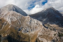
 Vihren from the north | |
| Highest point | |
| Elevation | 2,914 m (9,560 ft)[1] |
| Prominence | 1,783 m (5,850 ft)[1] |
| Listing | Ultra |
| Coordinates | 41°46′04″N 23°24′03″E / 41.76778°N 23.40083°E[1] |
| Geography | |
 Vihren Location in Bulgaria | |
| Location | Blagoevgrad Province, Bulgaria |
| Parent range | Pirin Mountains |
| Climbing | |
| Easiest route | Hike/scramble from Vihren refuge |
Geography edit

Vihren is situated in the northern subdivision of Pirin on the mountain's main ridge between the summits of Kutelo (2,908 m) to the north-west and Hvoynati Vrah (2,635 m) to the south-east.[4] It is connected with these two peaks via the saddles of Premkata (2,610 m) to the north and Kabata (2,535 m) to the south.[4] The summit is located between the valleys of the rivers Vlahina reka of the Struma drainage to the west and Banderitsa of the Mesta drainage to the east.[2]
Seen from the town of Bansko, situated at the foothills of Pirin to the north-east of Vihren, the peak looks like a truncated pyramid, and from the south — like а tetrahedral pyramid.[4] The summit is built up marbles[4] and has a karst topography which determines the lack of streams and lakes around Vihren. The closest lakes are the Vlahini Lakes to the south-west.[4] To the north are situated the deep and waterless cirques Golemiya Kazan and Malkiya Kazan, known as the Kazanite (the cauldrons).[4] Below the 450 m-high walls of Vihren facing Golemiya Kazan there is a small glacier called Snezhnika, which is Europe's southernmost glacial mass.[3][7] Its size in summer is 80x90 m.[8]
The average annual minimal temperature varies between –25° and –21°С, while the maximal temperatures are between 15° and 23°С. The mean annual precipitation is 1150 mm; the snow cover reaches depth of 3 m.[6] There is a meteorological station at 1,950 m.[6]
Wildlife edit

The wildlife is alpine. The flora of Vihren's slopes consists of herbaceous plants and lichens.[6] Vihren is home to a number of habitats, including alpine and sub-alpine open calcareous grasslands that at inclination of 30–45° at altitude over 2,500 m on the marble bedrock forms phytocenosis dominated by Sesleria korabensis,[9] and alpine and sub-alpine closed calcareous grasslands on very rocky bedrock.[10] With less abundance is the relict plant Carex rupestris; some plant communities have an abundance of Carex kitaibeliana and Sesleria coerulans.[9] There are also Alyssum cuneifolium, Bellardiochloa variegata, Bromus lacmonicus, Cerastium lanatum, Koeleria eriostachya, Onobrychis pindicola, Scutellaria alpina, Sesleria coerulans, etc.[10] Rare or endemic herbaceous plants that grow on the slopes of Vihren are edelweiss (Leontopodium alpinum),[11] Pirin poppy (Papaver degenii),[12] Oxytropis urumovii,[13] Alyssum pirinicum,[14] Timmia norvegica,[15] Thymus perinicus,[16] etc.
The fauna includes various bird species, small mammals and abundant populations of chamois.[6]
Tourism edit
Vihren is among the 100 Tourist Sites of Bulgaria under No. 2 and stamps to verify the visit can be found in the Museum of Nikola Vaptsarov in Bansko and in Vihren refuge.[6] The summit is part of the initiative of the Bulgarian Tourist Union "Conqueror of the Top Ten Mountain Peaks" to promote mountaineering.[17]
Vihren was first climbed in winter on 9 January 1925 by T.Atanasov, D.Stoykov, V.Baynov and N.Bozhinov.[4] The classical route to climb the peak is from the Vihren refuge (1,950 m) to the south via the Kabata saddle; this route takes three to four hours in summer and is steep, reaching denivelation of almost 1,000 m in а short time.[6] Other routes include those from the Banderitsa refuge (1,810 m) or across the knife-edge crest Koncheto from the north. From the Kazanite cirques in the north there is a 400 m-high steep wall which has several tracks from alpine climbing.[4] This wall was first climbed in 1934 by the German alpinists W.Mosel and F.Auer; in winter it was first ascended in 1949 by Al.Belkovski and Vl.Lobodin.[18]
From the top there is a view to almost the whole of northern Pirin, as well as to the mountain ranges of Rila, Rhodope, Maleshevo, Ograzhden, Belasica and Slavyanka.[19]
Honour edit
Vihren Peak on Livingston Island in the South Shetland Islands, Antarctica is named after Vihren.
See also edit
- Pirin
- Kutelo
- Pirin National Park
- List of mountains in Bulgaria
- Geography of Bulgaria
- List of mountains of the Balkans
- Southernmost glacial mass in Europe
- List of European ultra-prominent peaks
- List of the highest European ultra-prominent peaks
- Most isolated major summits of Europe
- List of mountain ranges
References edit
- ^ a b c "List of Ultra Prominent Peaks of Europe". Ultra Prominent Peaks. Retrieved 16 December 2017.
- ^ a b Geographic Dictionary of Bulgaria 1980, p. 112
- ^ a b Grunewald 2010, p. 129
- ^ a b c d e f g h i Dushkov 1972, p. 42
- ^ "History". Official Site of Pirin National Park. Retrieved 16 December 2017.
- ^ a b c d e f g "Vihren Peak". Official Site of the Bulgarian Tourist Union. Retrieved 16 December 2017.
- ^ Geographic Dictionary of Bulgaria 1980, p. 230
- ^ Dushkov 1972, p. 80
- ^ a b "Alpine and Sub-alpine Open Calcareous Grasslands". Red Book of Bulgaria, Volume III. Retrieved 16 December 2017.
- ^ a b "Alpine and Sub-alpine Closed Calcareous Grasslands". Red Book of Bulgaria, Volume III. Retrieved 16 December 2017.
- ^ "Leontopodium alpinum". Red Book of Bulgaria, Volume I. Retrieved 16 December 2017.
- ^ "Papaver degenii". Orbel Magazine. Retrieved 22 July 2018.
- ^ "Oxytropis urumovii". Red Book of Bulgaria, Volume I. Retrieved 16 December 2017.
- ^ "Alyssum pirinicum". Red Book of Bulgaria, Volume I. Retrieved 16 December 2017.
- ^ "Timmia norvegica". Red Book of Bulgaria, Volume I. Retrieved 16 December 2017.
- ^ "Thymus perinicus". Red Book of Bulgaria, Volume I. Retrieved 16 December 2017.
- ^ "Top Ten Peaks". Official Site of the Bulgarian Tourist Union. Retrieved 16 December 2017.
- ^ Dushkov 1972, pp. 42–43
- ^ Dushkov 1972, p. 43
References edit
- Мичев (Michev), Николай (Nikolay); Михайлов (Mihaylov), Цветко (Tsvetko); Вапцаров (Vaptsarov), Иван (Ivan); Кираджиев (Kiradzhiev), Светлин (Svetlin) (1980). Географски речник на България [Geographic Dictionary of Bulgaria] (in Bulgarian). София (Sofia): Наука и култура (Nauka i kultura).
- Душков (Dushkov), Добри (Dobri) (1972). Пирин. Туристически речник [Pirin. Tourist Dictionary] (in Bulgarian). София (Sofia): Наука и култура (Nauka i kultura).
- Grunewald, Karsten; Jörg Scheithauer (2010). "Europe's southernmost glaciers: response and adaptation to climate change" (PDF). Journal of Glaciology. 56. International Glaciological Society: 129–142. ISSN 0022-1430. Archived from the original (PDF) on 2 April 2015. Retrieved 6 March 2015.
External links edit
- "Pirin National Park". Official Site of Pirin National Park. Retrieved 6 December 2017.
- "Official Site of the Bulgarian Tourist Union". Retrieved 16 December 2017.
- "Ultra Prominent Peaks". Retrieved 16 December 2017.
- "Vihren". Peakbagger.com. Retrieved 16 December 2017.
- "Vihren webcam at 1972m". Retrieved 29 July 2020.